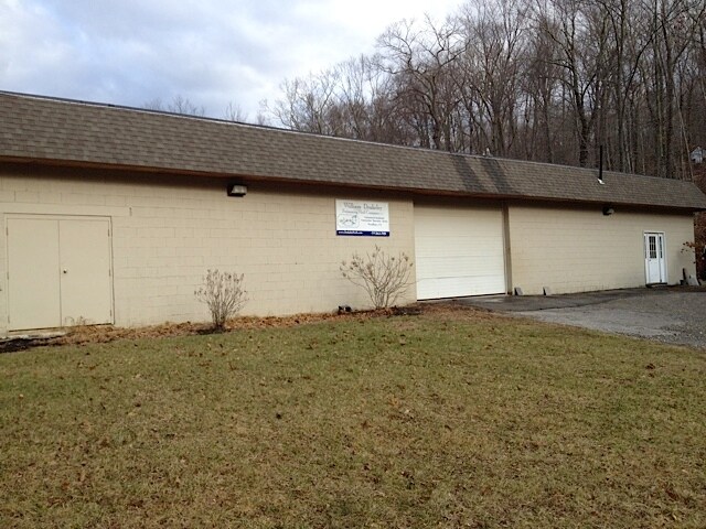
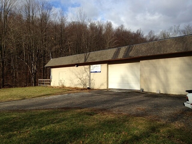
Property Record
74 Hickory Ln, Bethlehem, CT 06751

Save to a Folder
{{folder.Name}}
{{folder.ListingIds.length}} Properties
{{folder.ListingIds.length}} Property
Create a New Folder
Property Detail
74 Hickory Ln
BETH-000123-000000-000018B
Naugatuck Vly
Industrialgeneral
Connecticut
R-1
12.46 AC
2025
New Milford/SW L'fld
2025
Hartford
342100
Torrington, CT
3,960 SF
NEARBY LISTINGS FOR SALE OR LEASE
-
-
View all Bethlehem listings for sale on LoopNet.com
DEMOGRAPHICS near 74 Hickory Ln
1 mile
3 mile
5 mile
2025 Total Population
824
9,704
30,319
2030 Population
847
9,962
31,172
Pop Growth 2025-2030
+ 2.79%
+ 2.66%
+ 2.81%
Average Age
44
45
45
2025 Total Households
300
3,732
12,140
HH Growth 2025-2030
+ 2.67%
+ 2.63%
+ 2.80%
Median Household Inc
$133,088
$110,108
$102,639
Avg Household Size
2.70
2.50
2.40
2025 Avg HH Vehicles
2.00
2.00
2.00
Median Home Value
$428,915
$395,043
$367,441
Median Year Built
1974
1972
1970
Nearby Places
Map Layers
Map Styles
 Street
 Aerial
Layers
 Traffic
 Biking
Places
Listings with unknown addresses are not visible on the map
- Restaurants
- Banks
- Shops
- Fitness
- Groceries
PUBLIC TRANSPORTATION
COMMUTER RAIL
Waterbury Station (New Haven Line - Metro-North Commuter Railroad Company (Metro-North))
Drive
Walk
Distance
Waterbury Station (New Haven Line - Metro-North Commuter Railroad Company (Metro-North))
21 min
10.0 mi
AIRPORT
Tweed/New Haven
Drive
Walk
Distance
Tweed/New Haven
62 min
37.1 mi
Freight Ports
Port of New Haven
Drive
Walk
Distance
Port of New Haven
57 min
34.3 mi
Nearby Properties
Address
Land Use
TOTAL SIZE
Lot Size
Zoning
Address
Land Use
TOTAL SIZE
Lot Size
Zoning
75 AC
R20
Address
Land Use
TOTAL SIZE
Lot Size
Zoning
72,336 SF
15.39 AC
R30
Address
Land Use
TOTAL SIZE
Lot Size
Zoning
70.40 AC
R70
Address
Land Use
TOTAL SIZE
Lot Size
Zoning
97.74 AC
R-1
Address
Land Use
TOTAL SIZE
Lot Size
Zoning
48,949 SF
5.06 AC
R-1
Address
Land Use
TOTAL SIZE
Lot Size
Zoning
7.12 AC
R-1
Address
Land Use
TOTAL SIZE
Lot Size
Zoning
16 AC
R70
Address
Land Use
TOTAL SIZE
Lot Size
Zoning
157.47 AC
R90
Address
Land Use
TOTAL SIZE
Lot Size
Zoning
2.70 AC
R10
Address
Land Use
TOTAL SIZE
Lot Size
Zoning
2.98 AC
R10F
Address
Land Use
TOTAL SIZE
Lot Size
Zoning
37,184 SF
5 AC
OS60
Address
Land Use
TOTAL SIZE
Lot Size
Zoning
16.33 AC
R-1
Address
Land Use
TOTAL SIZE
Lot Size
Zoning
48.04 AC
R90
Address
Land Use
TOTAL SIZE
Lot Size
Zoning
1,200 SF
54 AC
R-1
Address
Land Use
TOTAL SIZE
Lot Size
Zoning
95.70 AC
R90
Address
Land Use
TOTAL SIZE
Lot Size
Zoning
256 SF
88.88 AC
R70
Address
Land Use
TOTAL SIZE
Lot Size
Zoning
15,089 SF
1.51 AC
R20
Address
Land Use
TOTAL SIZE
Lot Size
Zoning
1.75 AC
Address
Land Use
TOTAL SIZE
Lot Size
Zoning
7.46 AC
R20
Address
Land Use
TOTAL SIZE
Lot Size
Zoning
4.47 AC
R-1
Address
Land Use
TOTAL SIZE
Lot Size
Zoning
9.83 AC
IR80
Address
Land Use
TOTAL SIZE
Lot Size
Zoning
204.81 AC
R-1
Address
Land Use
TOTAL SIZE
Lot Size
Zoning
16.45 AC
R-1
Address
Land Use
TOTAL SIZE
Lot Size
Zoning
18.52 AC
R-1
Address
Land Use
TOTAL SIZE
Lot Size
Zoning
42,124 SF
5.51 AC
M
Address
Land Use
TOTAL SIZE
Lot Size
Zoning
19,192 SF
R90
Address
Land Use
TOTAL SIZE
Lot Size
Zoning
41.61 AC
R-1
Address
Land Use
TOTAL SIZE
Lot Size
Zoning
8.60 AC
R30
Address
Land Use
TOTAL SIZE
Lot Size
Zoning
8,192 SF
57.03 AC
R70
Address
Land Use
TOTAL SIZE
Lot Size
Zoning
2,827 SF
2.69 AC
R-1
The World's #1 Commercial Real Estate Marketplace
Connect with us
© 2026 CoStar Group
The information above has been obtained from sources believed reliable. While we do not doubt its accuracy we have not verified it and make no guarantee, warranty or representation about it. It is your responsibility to independently confirm its accuracy and completeness. Any projections, opinions, assumptions, or estimates used are for example only and do not represent the current or future performance of the property. The value of this transaction to you depends on tax and other factors which should be evaluated by your tax, financial, and legal advisors. You and your advisors should conduct a careful, independent investigation of the property to determine to your satisfaction the suitability of the property for your needs.