Property Record
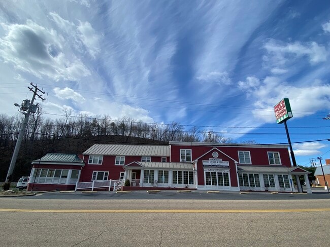
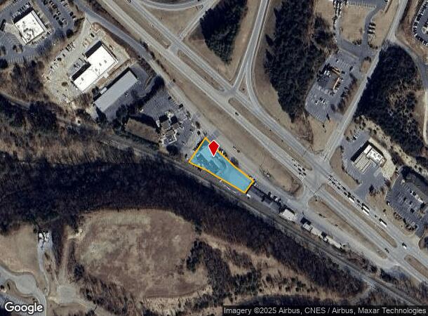
74 Rowe Rd, Staunton, VA 24401
This Property Is For Sale
NEARBY LISTINGS FOR SALE OR LEASE
Property Detail
74 Rowe Rd
056D1-1-19A
Verona
Restaurantbuilding
56D1-(1)-19A NEAR BRANDS .62 ACRES
AE
Augusta
51015C0343D
Virginia
2025
0.62 AC
2025
Staunton & Harrisonburg
070602
Other Market Areas
12,991 SF
Staunton-Waynesboro, VA
DEMOGRAPHICS near 74 Rowe Rd
1 Mile
3 Mile
5 Mile
2024 Total Population
955
14,847
40,655
2029 Population
1,023
15,359
41,817
Pop Growth 2024-2029
+ 7.12%
+ 3.45%
+ 2.86%
Average Age
43
42
42
2024 Total Households
404
6,332
17,394
HH Growth 2024-2029
+ 7.43%
+ 3.60%
+ 2.97%
Median Household Inc
$52,872
$50,432
$54,806
Avg Household Size
2.20
2.10
2.20
2024 Avg HH Vehicles
2.00
2.00
2.00
Median Home Value
$224,242
$229,690
$229,078
Median Year Built
1993
1974
1972
Nearby Places
Map Layers
Map Styles
 Street
 Aerial
- Restaurants
- Banks
- Shops
- Fitness
- Groceries
PUBLIC TRANSPORTATION
COMMUTER RAIL
Staunton Amtrak Station (Cardinal - Amtrak)
DRIVE
WALK
Distance
Staunton Amtrak Station (Cardinal - Amtrak)
5 min
3.0 mi
Freight Ports
Virginia Port Authority - Richmond
DRIVE
WALK
Distance
Virginia Port Authority - Richmond
130 min
111.9 mi
Nearby Properties
Address
Land Use
TOTAL SIZE
Lot Size
Zoning
Address
Land Use
TOTAL SIZE
Lot Size
Zoning
360,085 SF
66.35 AC
I-1
Address
Land Use
TOTAL SIZE
Lot Size
Zoning
103,815 SF
144.63 AC
GENERAL AG
Address
Land Use
TOTAL SIZE
Lot Size
Zoning
43,097 SF
72.85 AC
R3
Address
Land Use
TOTAL SIZE
Lot Size
Zoning
12,720 SF
13.10 AC
HE
Address
Land Use
TOTAL SIZE
Lot Size
Zoning
17,442 SF
22.14 AC
MULTI-FAMI
Address
Land Use
TOTAL SIZE
Lot Size
Zoning
17,442 SF
7.16 AC
MULTI-FAMI
Address
Land Use
TOTAL SIZE
Lot Size
Zoning
98,326 SF
14.62 AC
GENERAL AG
Address
Land Use
TOTAL SIZE
Lot Size
Zoning
20,304 SF
6.67 AC
R4
Address
Land Use
TOTAL SIZE
Lot Size
Zoning
54,796 SF
40 AC
MULTI-FAMI
Address
Land Use
TOTAL SIZE
Lot Size
Zoning
8,004 SF
24.91 AC
MULTI-FAMI
Address
Land Use
TOTAL SIZE
Lot Size
Zoning
32,976 SF
6.20 AC
R4
Address
Land Use
TOTAL SIZE
Lot Size
Zoning
202,650 SF
33.59 AC
B2
Address
Land Use
TOTAL SIZE
Lot Size
Zoning
72,933 SF
8.71 AC
B2
Address
Land Use
TOTAL SIZE
Lot Size
Zoning
18,750 SF
16.51 AC
HE
Address
Land Use
TOTAL SIZE
Lot Size
Zoning
158,300 SF
30 AC
R2
Address
Land Use
TOTAL SIZE
Lot Size
Zoning
66,309 SF
12.09 AC
B2
Address
Land Use
TOTAL SIZE
Lot Size
Zoning
61,798 SF
8.52 AC
R2
Address
Land Use
TOTAL SIZE
Lot Size
Zoning
100,501 SF
0.32 AC
B2
Address
Land Use
TOTAL SIZE
Lot Size
Zoning
54,507 SF
2.69 AC
B2
Address
Land Use
TOTAL SIZE
Lot Size
Zoning
25,002 SF
10.04 AC
R3
Address
Land Use
TOTAL SIZE
Lot Size
Zoning
56,600 SF
18.89 AC
B2
Address
Land Use
TOTAL SIZE
Lot Size
Zoning
44,378 SF
156.80 AC
GENERAL BU
Address
Land Use
TOTAL SIZE
Lot Size
Zoning
121,204 SF
12.99 AC
B2
Address
Land Use
TOTAL SIZE
Lot Size
Zoning
2,000 SF
79.58 AC
B1
Address
Land Use
TOTAL SIZE
Lot Size
Zoning
77,946 SF
2.67 AC
GENERAL BU
Address
Land Use
TOTAL SIZE
Lot Size
Zoning
41,264 SF
2.70 AC
B2
Address
Land Use
TOTAL SIZE
Lot Size
Zoning
33,661 SF
10.86 AC
GENERAL BU
Address
Land Use
TOTAL SIZE
Lot Size
Zoning
83,239 SF
8.15 AC
R4
Address
Land Use
TOTAL SIZE
Lot Size
Zoning
41,954 SF
3.40 AC
R1
Address
Land Use
TOTAL SIZE
Lot Size
Zoning
23,625 SF
1.14 AC
B-5
The World's #1 Commercial Real Estate Marketplace
Connect with us
© 2025 CoStar Group
The information above has been obtained from sources believed reliable. While we do not doubt its accuracy we have not verified it and make no guarantee, warranty or representation about it. It is your responsibility to independently confirm its accuracy and completeness. Any projections, opinions, assumptions, or estimates used are for example only and do not represent the current or future performance of the property. The value of this transaction to you depends on tax and other factors which should be evaluated by your tax, financial, and legal advisors. You and your advisors should conduct a careful, independent investigation of the property to determine to your satisfaction the suitability of the property for your needs.