Property Record
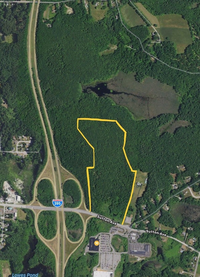
74 Sutton Ave, Oxford, MA 01540

This Property Is For Sale
NEARBY LISTINGS FOR SALE OR LEASE
Property Detail
74 Sutton Ave
OXFO-000036-000000-A000005
Worcester
Commercialacreage
Massachusetts
X
28.31 AC
09015C0075F
Outlying Worcester
2025
Boston
2025
Worcester, MA
753100
DEMOGRAPHICS near 74 Sutton Ave
1 mile
3 mile
5 mile
2024 Total Population
2,381
12,172
35,110
2029 Population
2,368
12,133
35,022
Pop Growth 2024-2029
(0.55%)
(0.32%)
(0.25%)
Average Age
44
43
43
2024 Total Households
1,004
4,778
14,270
HH Growth 2024-2029
(0.60%)
(0.38%)
(0.31%)
Median Household Inc
$86,390
$107,640
$95,487
Avg Household Size
2.30
2.50
2.40
2024 Avg HH Vehicles
2.00
2.00
2.00
Median Home Value
$369,155
$322,590
$349,381
Median Year Built
1966
1970
1969
Nearby Places
Map Layers
Map Styles
 Street
 Aerial
Transit
 Traffic
 Biking
Places
Listings with unknown addresses are not visible on the map
- Restaurants
- Banks
- Shops
- Fitness
- Groceries
PUBLIC TRANSPORTATION
AIRPORT
Worcester Regional
Drive
Walk
Distance
Worcester Regional
25 min
13.5 mi
Freight Ports
Port of Davisville, RI
Drive
Walk
Distance
Port of Davisville, RI
78 min
57.4 mi
Nearby Properties
Address
Land Use
TOTAL SIZE
Lot Size
Zoning
Address
Land Use
TOTAL SIZE
Lot Size
Zoning
34 AC
LI
Address
Land Use
TOTAL SIZE
Lot Size
Zoning
15.60 AC
R2
Address
Land Use
TOTAL SIZE
Lot Size
Zoning
13.22 AC
INDUST
Address
Land Use
TOTAL SIZE
Lot Size
Zoning
199,444 SF
179.03 AC
R1
Address
Land Use
TOTAL SIZE
Lot Size
Zoning
105,657 SF
12.65 AC
HI
Address
Land Use
TOTAL SIZE
Lot Size
Zoning
20.31 AC
INDUST
Address
Land Use
TOTAL SIZE
Lot Size
Zoning
81,491 SF
6.64 AC
HI
Address
Land Use
TOTAL SIZE
Lot Size
Zoning
109,380 SF
27.60 AC
R2
Address
Land Use
TOTAL SIZE
Lot Size
Zoning
60 AC
INDUST
Address
Land Use
TOTAL SIZE
Lot Size
Zoning
50,065 SF
8.65 AC
R3
Address
Land Use
TOTAL SIZE
Lot Size
Zoning
45,054 SF
6.60 AC
HI
Address
Land Use
TOTAL SIZE
Lot Size
Zoning
3,600 SF
9.52 AC
GB
Address
Land Use
TOTAL SIZE
Lot Size
Zoning
51,609 SF
10.24 AC
R3
Address
Land Use
TOTAL SIZE
Lot Size
Zoning
9,496 SF
13.25 AC
R3
Address
Land Use
TOTAL SIZE
Lot Size
Zoning
10 AC
LI
Address
Land Use
TOTAL SIZE
Lot Size
Zoning
70,471 SF
36.41 AC
I
Address
Land Use
TOTAL SIZE
Lot Size
Zoning
71,884 SF
7.01 AC
I
Address
Land Use
TOTAL SIZE
Lot Size
Zoning
69,192 SF
22.85 AC
I
Address
Land Use
TOTAL SIZE
Lot Size
Zoning
6,908 SF
3.95 AC
R1
Address
Land Use
TOTAL SIZE
Lot Size
Zoning
32,192 SF
12.90 AC
R3
Address
Land Use
TOTAL SIZE
Lot Size
Zoning
21,045 SF
2 AC
INDUST
Address
Land Use
TOTAL SIZE
Lot Size
Zoning
14,478 SF
1.06 AC
R2
Address
Land Use
TOTAL SIZE
Lot Size
Zoning
2.81 AC
VB
Address
Land Use
TOTAL SIZE
Lot Size
Zoning
45,920 SF
3.50 AC
I
Address
Land Use
TOTAL SIZE
Lot Size
Zoning
8.47 AC
R1
Address
Land Use
TOTAL SIZE
Lot Size
Zoning
Address
Land Use
TOTAL SIZE
Lot Size
Zoning
1.70 AC
VB
Address
Land Use
TOTAL SIZE
Lot Size
Zoning
9,000 SF
17.98 AC
IND
Address
Land Use
TOTAL SIZE
Lot Size
Zoning
3,000 SF
31.82 AC
R1
Address
Land Use
TOTAL SIZE
Lot Size
Zoning
42,139 SF
4.54 AC
GB
The World's #1 Commercial Real Estate Marketplace
Connect with us
© 2026 CoStar Group
The information above has been obtained from sources believed reliable. While we do not doubt its accuracy we have not verified it and make no guarantee, warranty or representation about it. It is your responsibility to independently confirm its accuracy and completeness. Any projections, opinions, assumptions, or estimates used are for example only and do not represent the current or future performance of the property. The value of this transaction to you depends on tax and other factors which should be evaluated by your tax, financial, and legal advisors. You and your advisors should conduct a careful, independent investigation of the property to determine to your satisfaction the suitability of the property for your needs.