Property Record
740 82Nd Dr, Gladstone, OR 97027
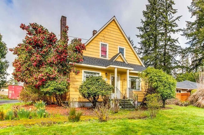


Property Detail
740 82Nd Dr
00545262
181 PARK SUB OF GLADSTONE PT LT 15 BLK 135
Commercialbuilding
Clackamas
C3
Oregon
C and X Area of minimal flood hazard, usually depicted on FIRMs as above the 500-year flood level.
15
2025
0.70 AC
2025
Clackamas/Milwaukie
022108
Portland
2,210 SF
Portland-Vancouver-Hillsboro, OR-WA
NEARBY LISTINGS FOR SALE OR LEASE
DEMOGRAPHICS near 740 82Nd Dr
1 mile
3 mile
5 mile
2025 Total Population
8,336
64,469
206,927
2030 Population
8,423
64,520
207,474
Pop Growth 2025-2030
+ 1.04%
+ 0.08%
+ 0.26%
Average Age
43
43
42
2025 Total Households
3,141
25,054
79,453
HH Growth 2025-2030
+ 0.96%
+ 0.02%
+ 0.22%
Median Household Inc
$101,218
$91,562
$97,220
Avg Household Size
2.50
2.50
2.50
2025 Avg HH Vehicles
2.00
2.00
2.00
Median Home Value
$527,990
$567,162
$622,397
Median Year Built
1977
1977
1983
Nearby Places
Map Layers
Map Styles
 Street
 Aerial
Layers
 Traffic
 Biking
Places
Listings with unknown addresses are not visible on the map
- Restaurants
- Banks
- Shops
- Fitness
- Groceries
PUBLIC TRANSPORTATION
COMMUTER RAIL
Oregon City Amtrak (Amtrak Cascades - Amtrak)
Drive
Walk
Distance
Oregon City Amtrak (Amtrak Cascades - Amtrak)
5 min
2.3 mi
AIRPORT
Portland International
Drive
Walk
Distance
Portland International
25 min
16.6 mi
Freight Ports
Port of Portland
Drive
Walk
Distance
Port of Portland
29 min
16.3 mi
SALE & LEASE HISTORY
LISTING DATE
SALE/LEASE

Apr 07, 2017
For Sale
Nearby Properties
Address
Land Use
TOTAL SIZE
Lot Size
Zoning
Address
Land Use
TOTAL SIZE
Lot Size
Zoning
15.26 AC
GI
Address
Land Use
TOTAL SIZE
Lot Size
Zoning
40.94 AC
IPU
Address
Land Use
TOTAL SIZE
Lot Size
Zoning
9,233 SF
8.27 AC
MUE
Address
Land Use
TOTAL SIZE
Lot Size
Zoning
4,654 SF
73.99 AC
LI
Address
Land Use
TOTAL SIZE
Lot Size
Zoning
45 AC
GI
Address
Land Use
TOTAL SIZE
Lot Size
Zoning
Address
Land Use
TOTAL SIZE
Lot Size
Zoning
Address
Land Use
TOTAL SIZE
Lot Size
Zoning
22.99 AC
LI
Address
Land Use
TOTAL SIZE
Lot Size
Zoning
Address
Land Use
TOTAL SIZE
Lot Size
Zoning
24 AC
LI
Address
Land Use
TOTAL SIZE
Lot Size
Zoning
12.16 AC
C3
Address
Land Use
TOTAL SIZE
Lot Size
Zoning
20 AC
RTL
Address
Land Use
TOTAL SIZE
Lot Size
Zoning
14.06 AC
C3
Address
Land Use
TOTAL SIZE
Lot Size
Zoning
Address
Land Use
TOTAL SIZE
Lot Size
Zoning
6 AC
GI
Address
Land Use
TOTAL SIZE
Lot Size
Zoning
12 AC
LI
Address
Land Use
TOTAL SIZE
Lot Size
Zoning
7.25 AC
LI
Address
Land Use
TOTAL SIZE
Lot Size
Zoning
3.10 AC
RCO
Address
Land Use
TOTAL SIZE
Lot Size
Zoning
17.04 AC
GI
Address
Land Use
TOTAL SIZE
Lot Size
Zoning
10.11 AC
MR2
Address
Land Use
TOTAL SIZE
Lot Size
Zoning
6.68 AC
C3
Address
Land Use
TOTAL SIZE
Lot Size
Zoning
2,510 SF
16.02 AC
GI
Address
Land Use
TOTAL SIZE
Lot Size
Zoning
11.69 AC
OC
Address
Land Use
TOTAL SIZE
Lot Size
Zoning
3.11 AC
GC
Address
Land Use
TOTAL SIZE
Lot Size
Zoning
2,482 SF
5.14 AC
MR
Address
Land Use
TOTAL SIZE
Lot Size
Zoning
11 AC
MUD
Address
Land Use
TOTAL SIZE
Lot Size
Zoning
16.49 AC
MUD
Address
Land Use
TOTAL SIZE
Lot Size
Zoning
Address
Land Use
TOTAL SIZE
Lot Size
Zoning
70.97 AC
OP
Address
Land Use
TOTAL SIZE
Lot Size
Zoning
The World's #1 Commercial Real Estate Marketplace
Connect with us
© 2026 CoStar Group
The information above has been obtained from sources believed reliable. While we do not doubt its accuracy we have not verified it and make no guarantee, warranty or representation about it. It is your responsibility to independently confirm its accuracy and completeness. Any projections, opinions, assumptions, or estimates used are for example only and do not represent the current or future performance of the property. The value of this transaction to you depends on tax and other factors which should be evaluated by your tax, financial, and legal advisors. You and your advisors should conduct a careful, independent investigation of the property to determine to your satisfaction the suitability of the property for your needs.