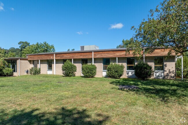
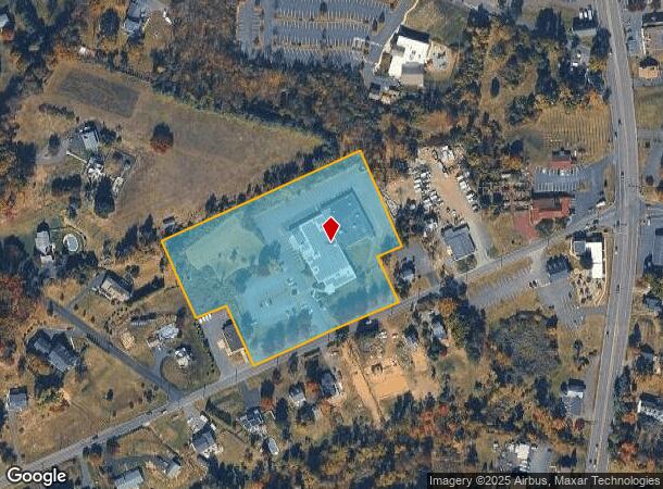
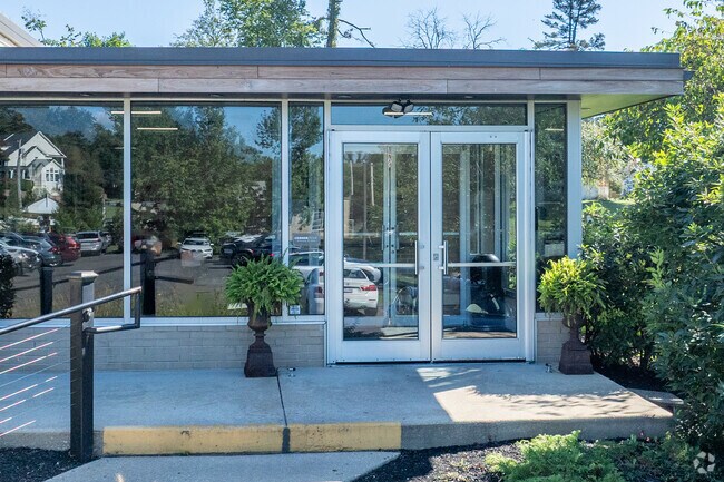
Property Record
740 Edison Furlong Rd, Furlong, PA 18925
NEARBY LISTINGS FOR SALE OR LEASE
Property Detail
740 Edison Furlong Rd
09-022-122-001
Robert W Button
Gymhealthspa
5.38AC NS SR2079 210 E OF T386 430 ON EDISON FURLONG RD
X
Bucks
42017C0312J
Pennsylvania
2024
5.38 AC
2025
Upper Bucks County
104601
Philadelphia
31,476 SF
Philadelphia-Camden-Wilmington, PA-NJ-DE-MD
DEMOGRAPHICS near 740 Edison Furlong Rd
1 Mile
3 Mile
5 Mile
2024 Total Population
4,962
30,239
84,706
2029 Population
4,896
29,978
84,454
Pop Growth 2024-2029
(1.33%)
(0.86%)
(0.30%)
Average Age
41
45
44
2024 Total Households
1,639
11,093
31,142
HH Growth 2024-2029
(1.40%)
(0.94%)
(0.24%)
Median Household Inc
$184,457
$144,029
$128,719
Avg Household Size
3.00
2.60
2.60
2024 Avg HH Vehicles
2.00
2.00
2.00
Median Home Value
$629,268
$628,683
$531,866
Median Year Built
2000
1981
1986
Nearby Places
- Restaurants
- Banks
- Shops
- Fitness
- Groceries
PUBLIC TRANSPORTATION
COMMUTER RAIL
Doylestown (R5 - Southeastern Pennsylvania Transportation Authority Regional Rail (SEPTA Regional Rail))
DRIVE
WALK
Distance
Doylestown (R5 - Southeastern Pennsylvania Transportation Authority Regional Rail (SEPTA Regional Rail))
7 min
3.1 mi
Delaware Valley College (R5 - Southeastern Pennsylvania Transportation Authority Regional Rail (SEPTA Regional Rail))
DRIVE
WALK
Distance
Delaware Valley College (R5 - Southeastern Pennsylvania Transportation Authority Regional Rail (SEPTA Regional Rail))
10 min
5.7 mi
AIRPORT
Trenton Mercer
DRIVE
WALK
Distance
Trenton Mercer
34 min
20.2 mi
Freight Ports
Port of Philadelphia
DRIVE
WALK
Distance
Port of Philadelphia
45 min
25.9 mi
Nearby Properties
Address
Land Use
TOTAL SIZE
Lot Size
Zoning
Address
Land Use
TOTAL SIZE
Lot Size
Zoning
254,699 SF
22.06 AC
RC
Address
Land Use
TOTAL SIZE
Lot Size
Zoning
254,330 SF
25.38 AC
C2
Address
Land Use
TOTAL SIZE
Lot Size
Zoning
146,924 SF
17.47 AC
C2
Address
Land Use
TOTAL SIZE
Lot Size
Zoning
77,630 SF
28.53 AC
R2B
Address
Land Use
TOTAL SIZE
Lot Size
Zoning
89,417 SF
13.30 AC
CR
Address
Land Use
TOTAL SIZE
Lot Size
Zoning
77,964 SF
9.79 AC
R3
Address
Land Use
TOTAL SIZE
Lot Size
Zoning
54,090 SF
7.25 AC
R4
Address
Land Use
TOTAL SIZE
Lot Size
Zoning
5,588 SF
0.82 AC
FC
Address
Land Use
TOTAL SIZE
Lot Size
Zoning
16,828 SF
3.28 AC
R2
Address
Land Use
TOTAL SIZE
Lot Size
Zoning
38,320 SF
11.91 AC
AG
Address
Land Use
TOTAL SIZE
Lot Size
Zoning
92,454 SF
12.48 AC
R1
Address
Land Use
TOTAL SIZE
Lot Size
Zoning
51,286 SF
12.56 AC
R1
Address
Land Use
TOTAL SIZE
Lot Size
Zoning
24,300 SF
3.36 AC
C1
Address
Land Use
TOTAL SIZE
Lot Size
Zoning
21,285 SF
118.88 AC
R1
Address
Land Use
TOTAL SIZE
Lot Size
Zoning
63,524 SF
6.06 AC
C1
Address
Land Use
TOTAL SIZE
Lot Size
Zoning
25,043 SF
0.36 AC
LC
Address
Land Use
TOTAL SIZE
Lot Size
Zoning
32,298 SF
3.97 AC
R3
Address
Land Use
TOTAL SIZE
Lot Size
Zoning
45,479 SF
6.79 AC
LC
Address
Land Use
TOTAL SIZE
Lot Size
Zoning
36,635 SF
2.97 AC
CR-H
Address
Land Use
TOTAL SIZE
Lot Size
Zoning
8.22 AC
C2
Address
Land Use
TOTAL SIZE
Lot Size
Zoning
23,038 SF
149.20 AC
AG
Address
Land Use
TOTAL SIZE
Lot Size
Zoning
34,068 SF
1.09 AC
R2
Address
Land Use
TOTAL SIZE
Lot Size
Zoning
38,530 SF
2.38 AC
RC1
Address
Land Use
TOTAL SIZE
Lot Size
Zoning
190,326 SF
8.95 AC
C1
Address
Land Use
TOTAL SIZE
Lot Size
Zoning
39,936 SF
3.13 AC
RC
Address
Land Use
TOTAL SIZE
Lot Size
Zoning
33,094 SF
4.68 AC
C
Address
Land Use
TOTAL SIZE
Lot Size
Zoning
16,300 SF
1.54 AC
FC
Address
Land Use
TOTAL SIZE
Lot Size
Zoning
57,000 SF
6.60 AC
C1
Address
Land Use
TOTAL SIZE
Lot Size
Zoning
4,782 SF
1.76 AC
R3
Address
Land Use
TOTAL SIZE
Lot Size
Zoning
10,965 SF
1.78 AC
RC1
The World's #1 Commercial Real Estate Marketplace
Connect with us
© 2025 CoStar Group
The information above has been obtained from sources believed reliable. While we do not doubt its accuracy we have not verified it and make no guarantee, warranty or representation about it. It is your responsibility to independently confirm its accuracy and completeness. Any projections, opinions, assumptions, or estimates used are for example only and do not represent the current or future performance of the property. The value of this transaction to you depends on tax and other factors which should be evaluated by your tax, financial, and legal advisors. You and your advisors should conduct a careful, independent investigation of the property to determine to your satisfaction the suitability of the property for your needs.