Property Record
740 Generals Hwy, Millersville, MD 21108
Current Lease Availabilities
NEARBY LISTINGS FOR SALE OR LEASE
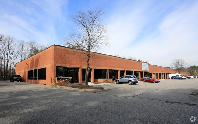
Property Detail
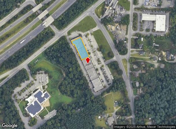
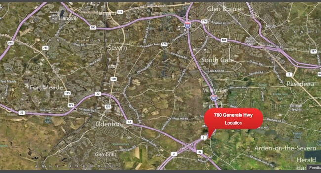
740 Generals Hwy
Baltimore-Columbia-Towson, MD
Severn Run Condo
04-000-00050800
UNIT 1 SEVERN RUN CONDO
Warehouse
Anne Arundel
X
Maryland
24003C0134E
1
2024
5 AC
2025
I-97/Crain Hwy Corrid
740800
Baltimore
11,353 SF
DEMOGRAPHICS near 740 Generals Hwy
1 Mile
3 Mile
5 Mile
2024 Total Population
784
25,181
147,779
2029 Population
815
25,739
151,150
Pop Growth 2024-2029
+ 3.95%
+ 2.22%
+ 2.28%
Average Age
44
42
39
2024 Total Households
295
8,917
54,889
HH Growth 2024-2029
+ 3.73%
+ 2.29%
+ 2.38%
Median Household Inc
$118,160
$142,996
$118,380
Avg Household Size
2.60
2.80
2.60
2024 Avg HH Vehicles
3.00
2.00
2.00
Median Home Value
$479,774
$608,881
$451,179
Median Year Built
1976
1980
1989
Nearby Places
- Restaurants
- Banks
- Shops
- Fitness
- Groceries
PUBLIC TRANSPORTATION
COMMUTER RAIL
Odenton (Penn Line - Maryland Area Regional Commuter Trains (The MARC))
DRIVE
WALK
Distance
Odenton (Penn Line - Maryland Area Regional Commuter Trains (The MARC))
11 min
5.0 mi
AIRPORT
Baltimore/Washington International Thurgood Marshall
DRIVE
WALK
Distance
Baltimore/Washington International Thurgood Marshall
21 min
12.2 mi
Ronald Reagan Washington Ntl
DRIVE
WALK
Distance
Ronald Reagan Washington Ntl
50 min
33.1 mi
Freight Ports
Port of Baltimore
DRIVE
WALK
Distance
Port of Baltimore
27 min
17.4 mi
Nearby Properties
Address
Land Use
TOTAL SIZE
Lot Size
Zoning
Address
Land Use
TOTAL SIZE
Lot Size
Zoning
14.65 AC
R15
Address
Land Use
TOTAL SIZE
Lot Size
Zoning
311,870 SF
10.03 AC
Address
Land Use
TOTAL SIZE
Lot Size
Zoning
277,037 SF
10.45 AC
R5
Address
Land Use
TOTAL SIZE
Lot Size
Zoning
125.95 AC
R5
Address
Land Use
TOTAL SIZE
Lot Size
Zoning
43,842 SF
27.74 AC
C4
Address
Land Use
TOTAL SIZE
Lot Size
Zoning
139,230 SF
39.22 AC
R2
Address
Land Use
TOTAL SIZE
Lot Size
Zoning
154,056 SF
19.89 AC
R2
Address
Land Use
TOTAL SIZE
Lot Size
Zoning
128,466 SF
18.70 AC
W1
Address
Land Use
TOTAL SIZE
Lot Size
Zoning
98,109 SF
5.33 AC
C2
Address
Land Use
TOTAL SIZE
Lot Size
Zoning
46,896 SF
3.29 AC
C1B
Address
Land Use
TOTAL SIZE
Lot Size
Zoning
48,036 SF
15.99 AC
RLD
Address
Land Use
TOTAL SIZE
Lot Size
Zoning
87,878 SF
3.91 AC
C4
Address
Land Use
TOTAL SIZE
Lot Size
Zoning
58,512 SF
3.91 AC
O-EOD
Address
Land Use
TOTAL SIZE
Lot Size
Zoning
67,727 SF
4.65 AC
C4
Address
Land Use
TOTAL SIZE
Lot Size
Zoning
86,100 SF
2.32 AC
C4
Address
Land Use
TOTAL SIZE
Lot Size
Zoning
49,713 SF
5 AC
R1
Address
Land Use
TOTAL SIZE
Lot Size
Zoning
167,939 SF
24.48 AC
W1
Address
Land Use
TOTAL SIZE
Lot Size
Zoning
55,291 SF
20.77 AC
R2
Address
Land Use
TOTAL SIZE
Lot Size
Zoning
75,540 SF
10.10 AC
W1
Address
Land Use
TOTAL SIZE
Lot Size
Zoning
5,474 SF
3.11 AC
C4
Address
Land Use
TOTAL SIZE
Lot Size
Zoning
123,000 SF
9.92 AC
W1
Address
Land Use
TOTAL SIZE
Lot Size
Zoning
47,358 SF
38.77 AC
R1
Address
Land Use
TOTAL SIZE
Lot Size
Zoning
32,892 SF
18.11 AC
C2
Address
Land Use
TOTAL SIZE
Lot Size
Zoning
45,265 SF
5.04 AC
W1
Address
Land Use
TOTAL SIZE
Lot Size
Zoning
47,311 SF
4.33 AC
W1
Address
Land Use
TOTAL SIZE
Lot Size
Zoning
5,636 SF
9.38 AC
C4
Address
Land Use
TOTAL SIZE
Lot Size
Zoning
34,392 SF
2.91 AC
C2
Address
Land Use
TOTAL SIZE
Lot Size
Zoning
40,790 SF
4.10 AC
W1
Address
Land Use
TOTAL SIZE
Lot Size
Zoning
2,784 SF
20.79 AC
C4
Address
Land Use
TOTAL SIZE
Lot Size
Zoning
23,092 SF
61.59 AC
R1
The World's #1 Commercial Real Estate Marketplace
Connect with us
© 2025 CoStar Group
The information above has been obtained from sources believed reliable. While we do not doubt its accuracy we have not verified it and make no guarantee, warranty or representation about it. It is your responsibility to independently confirm its accuracy and completeness. Any projections, opinions, assumptions, or estimates used are for example only and do not represent the current or future performance of the property. The value of this transaction to you depends on tax and other factors which should be evaluated by your tax, financial, and legal advisors. You and your advisors should conduct a careful, independent investigation of the property to determine to your satisfaction the suitability of the property for your needs.