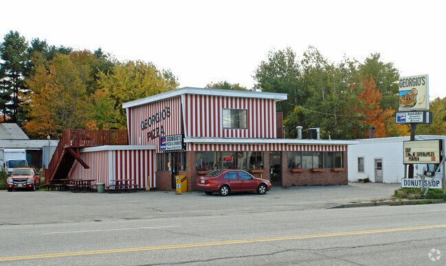
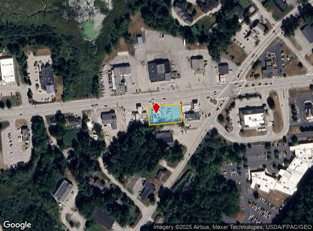
Property Record
740 Minot Ave, Auburn, ME 04210
NEARBY LISTINGS FOR SALE OR LEASE
Property Detail
740 Minot Ave
AUBN-000208-000000-000017
Androscoggin
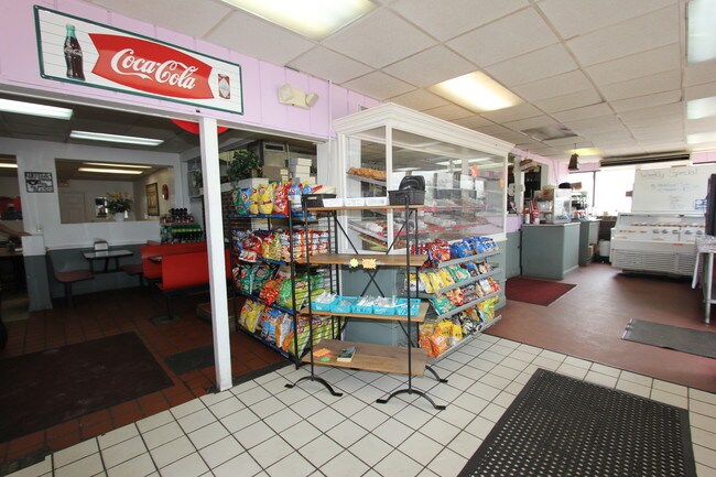
Restaurantbuilding
Maine
AE
17
23001C0309E
0.38 AC
2024
Portland Surrounding
2024
Other Market Areas
010700
Lewiston-Auburn, ME
3,296 SF
DEMOGRAPHICS near 740 Minot Ave
1 Mile
3 Mile
5 Mile
2024 Total Population
3,841
35,698
58,044
2029 Population
3,934
36,239
58,726
Pop Growth 2024-2029
+ 2.42%
+ 1.52%
+ 1.17%
Average Age
47
39
41
2024 Total Households
1,488
14,785
23,884
HH Growth 2024-2029
+ 2.28%
+ 1.49%
+ 1.11%
Median Household Inc
$68,739
$45,416
$50,813
Avg Household Size
2.20
2.20
2.20
2024 Avg HH Vehicles
2.00
1.00
1.00
Median Home Value
$218,925
$213,065
$207,078
Median Year Built
1960
1948
1953
Nearby Places
Map Layers
Map Styles
 Street
 Aerial
- Restaurants
- Banks
- Shops
- Fitness
- Groceries
SALE & LEASE HISTORY
LISTING DATE
SALE/LEASE

Jul 15, 2019
For Sale
Jul 11, 2018
For Sale
Nearby Properties
Address
Land Use
TOTAL SIZE
Lot Size
Zoning
Address
Land Use
TOTAL SIZE
Lot Size
Zoning
542,760 SF
8.12 AC
Address
Land Use
TOTAL SIZE
Lot Size
Zoning
290,822 SF
61.58 AC
Address
Land Use
TOTAL SIZE
Lot Size
Zoning
Address
Land Use
TOTAL SIZE
Lot Size
Zoning
34,797 SF
10.98 AC
Address
Land Use
TOTAL SIZE
Lot Size
Zoning
50,000 SF
86.08 AC
Address
Land Use
TOTAL SIZE
Lot Size
Zoning
1.53 AC
Address
Land Use
TOTAL SIZE
Lot Size
Zoning
49,842 SF
23 AC
Address
Land Use
TOTAL SIZE
Lot Size
Zoning
144,650 SF
16.19 AC
Address
Land Use
TOTAL SIZE
Lot Size
Zoning
220,227 SF
35.93 AC
Address
Land Use
TOTAL SIZE
Lot Size
Zoning
106,600 SF
0.73 AC
Address
Land Use
TOTAL SIZE
Lot Size
Zoning
511,690 SF
139.18 AC
Address
Land Use
TOTAL SIZE
Lot Size
Zoning
27,606 SF
1.10 AC
Address
Land Use
TOTAL SIZE
Lot Size
Zoning
77,416 SF
2.88 AC
Address
Land Use
TOTAL SIZE
Lot Size
Zoning
90,085 SF
1.49 AC
Address
Land Use
TOTAL SIZE
Lot Size
Zoning
210,388 SF
1.46 AC
Address
Land Use
TOTAL SIZE
Lot Size
Zoning
134,613 SF
26.87 AC
Address
Land Use
TOTAL SIZE
Lot Size
Zoning
76,915 SF
1.83 AC
Address
Land Use
TOTAL SIZE
Lot Size
Zoning
129,113 SF
7.50 AC
Address
Land Use
TOTAL SIZE
Lot Size
Zoning
49,638 SF
0.76 AC
Address
Land Use
TOTAL SIZE
Lot Size
Zoning
3,027 SF
13.19 AC
Address
Land Use
TOTAL SIZE
Lot Size
Zoning
114,670 SF
12.85 AC
Address
Land Use
TOTAL SIZE
Lot Size
Zoning
93,949 SF
1.40 AC
Address
Land Use
TOTAL SIZE
Lot Size
Zoning
185,466 SF
0.97 AC
Address
Land Use
TOTAL SIZE
Lot Size
Zoning
153,752 SF
132.60 AC
Address
Land Use
TOTAL SIZE
Lot Size
Zoning
82,748 SF
26.27 AC
Address
Land Use
TOTAL SIZE
Lot Size
Zoning
278,946 SF
16.83 AC
Address
Land Use
TOTAL SIZE
Lot Size
Zoning
109,282 SF
20.80 AC
Address
Land Use
TOTAL SIZE
Lot Size
Zoning
53,352 SF
1.02 AC
Address
Land Use
TOTAL SIZE
Lot Size
Zoning
111,920 SF
0.96 AC
Address
Land Use
TOTAL SIZE
Lot Size
Zoning
41,771 SF
17.10 AC
The World's #1 Commercial Real Estate Marketplace
Connect with us
© 2025 CoStar Group
The information above has been obtained from sources believed reliable. While we do not doubt its accuracy we have not verified it and make no guarantee, warranty or representation about it. It is your responsibility to independently confirm its accuracy and completeness. Any projections, opinions, assumptions, or estimates used are for example only and do not represent the current or future performance of the property. The value of this transaction to you depends on tax and other factors which should be evaluated by your tax, financial, and legal advisors. You and your advisors should conduct a careful, independent investigation of the property to determine to your satisfaction the suitability of the property for your needs.