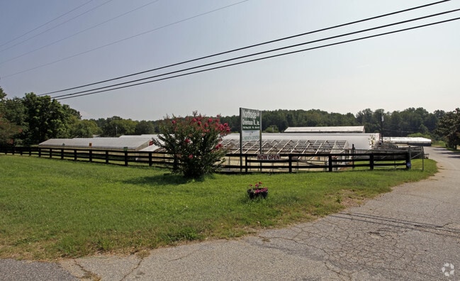
Property Record
740 N Highway 25, Travelers Rest, SC 29690

NEARBY LISTINGS FOR SALE OR LEASE
Property Detail
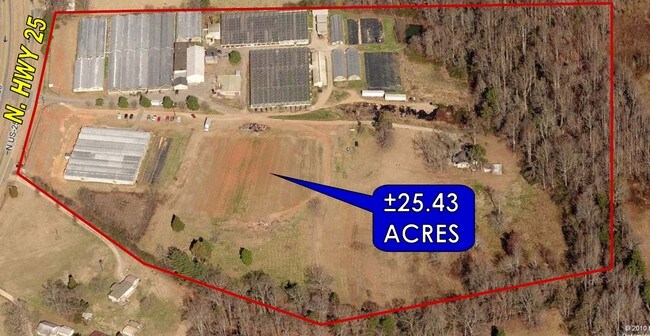
740 N Highway 25
Greenville-Anderson-Greer, SC
Property Of Northside Greenhouses
0501.02-01-061.02
MAP 0501.02
Storebuilding
Greenville
X
South Carolina
45045C0310E
061.02
2025
9.80 AC
2024
Travelers Rest
003902
Greenville/Spartanburg
DEMOGRAPHICS near 740 N Highway 25
1 Mile
3 Mile
5 Mile
2024 Total Population
1,041
12,341
31,473
2029 Population
1,152
13,640
34,639
Pop Growth 2024-2029
+ 10.66%
+ 10.53%
+ 10.06%
Average Age
43
42
41
2024 Total Households
403
4,815
11,480
HH Growth 2024-2029
+ 10.67%
+ 10.61%
+ 10.56%
Median Household Inc
$60,129
$58,287
$64,708
Avg Household Size
2.50
2.50
2.50
2024 Avg HH Vehicles
2.00
2.00
2.00
Median Home Value
$286,363
$266,909
$272,614
Median Year Built
1990
1992
1993
Nearby Places
Map Layers
Map Styles
 Street
 Aerial
- Restaurants
- Banks
- Shops
- Fitness
- Groceries
PUBLIC TRANSPORTATION
AIRPORT
Greenville Spartanburg International
DRIVE
WALK
Distance
Greenville Spartanburg International
39 min
19.8 mi
Freight Ports
North Charleston Terminal
DRIVE
WALK
Distance
North Charleston Terminal
247 min
214.7 mi
Nearby Properties
Address
Land Use
TOTAL SIZE
Lot Size
Zoning
Address
Land Use
TOTAL SIZE
Lot Size
Zoning
3.93 AC
R10
Address
Land Use
TOTAL SIZE
Lot Size
Zoning
19.25 AC
R15
Address
Land Use
TOTAL SIZE
Lot Size
Zoning
14.40 AC
I1
Address
Land Use
TOTAL SIZE
Lot Size
Zoning
7.56 AC
C2
Address
Land Use
TOTAL SIZE
Lot Size
Zoning
159 AC
UNZONED
Address
Land Use
TOTAL SIZE
Lot Size
Zoning
6.22 AC
I1
Address
Land Use
TOTAL SIZE
Lot Size
Zoning
55.70 AC
UNZONED
Address
Land Use
TOTAL SIZE
Lot Size
Zoning
4.97 AC
C2
Address
Land Use
TOTAL SIZE
Lot Size
Zoning
9.60 AC
I1
Address
Land Use
TOTAL SIZE
Lot Size
Zoning
1,491 SF
27.82 AC
R15
Address
Land Use
TOTAL SIZE
Lot Size
Zoning
11.56 AC
I1
Address
Land Use
TOTAL SIZE
Lot Size
Zoning
24.45 AC
I1
Address
Land Use
TOTAL SIZE
Lot Size
Zoning
2.58 AC
PDR
Address
Land Use
TOTAL SIZE
Lot Size
Zoning
15.31 AC
UNZONED
Address
Land Use
TOTAL SIZE
Lot Size
Zoning
4.40 AC
I1
Address
Land Use
TOTAL SIZE
Lot Size
Zoning
58.70 AC
R75
Address
Land Use
TOTAL SIZE
Lot Size
Zoning
19.10 AC
NZ
Address
Land Use
TOTAL SIZE
Lot Size
Zoning
19.60 AC
NZ
Address
Land Use
TOTAL SIZE
Lot Size
Zoning
64.96 AC
UNZONED
Address
Land Use
TOTAL SIZE
Lot Size
Zoning
14.01 AC
C2
Address
Land Use
TOTAL SIZE
Lot Size
Zoning
40.21 AC
UNZONED
Address
Land Use
TOTAL SIZE
Lot Size
Zoning
2,414 SF
11.48 AC
NZ
Address
Land Use
TOTAL SIZE
Lot Size
Zoning
13 AC
I1
Address
Land Use
TOTAL SIZE
Lot Size
Zoning
1.56 AC
C1
Address
Land Use
TOTAL SIZE
Lot Size
Zoning
24.64 AC
UNZONED
Address
Land Use
TOTAL SIZE
Lot Size
Zoning
69 AC
PUD
Address
Land Use
TOTAL SIZE
Lot Size
Zoning
34.47 AC
UNZONED
Address
Land Use
TOTAL SIZE
Lot Size
Zoning
8.90 AC
S1
Address
Land Use
TOTAL SIZE
Lot Size
Zoning
2.12 AC
C2
Address
Land Use
TOTAL SIZE
Lot Size
Zoning
29.08 AC
The World's #1 Commercial Real Estate Marketplace
Connect with us
© 2026 CoStar Group
The information above has been obtained from sources believed reliable. While we do not doubt its accuracy we have not verified it and make no guarantee, warranty or representation about it. It is your responsibility to independently confirm its accuracy and completeness. Any projections, opinions, assumptions, or estimates used are for example only and do not represent the current or future performance of the property. The value of this transaction to you depends on tax and other factors which should be evaluated by your tax, financial, and legal advisors. You and your advisors should conduct a careful, independent investigation of the property to determine to your satisfaction the suitability of the property for your needs.