Property Record
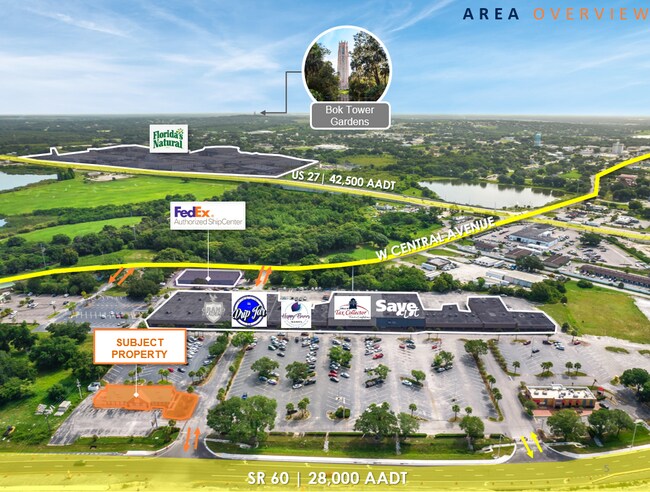
740 State Road 60 W, Lake Wales, FL 33853
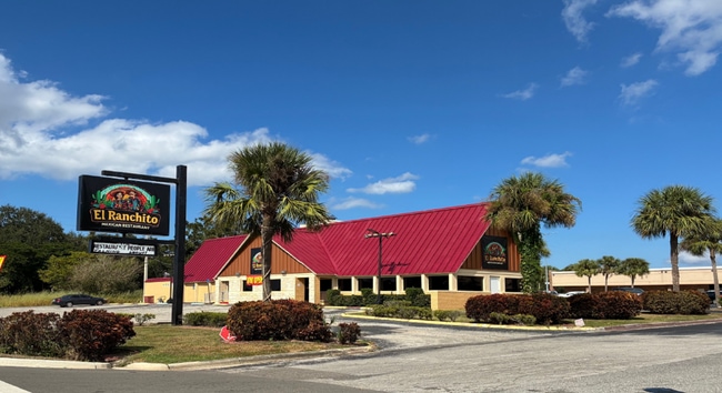

This Property Is For Sale
NEARBY LISTINGS FOR SALE OR LEASE
Property Detail
740 State Road 60 W
27-30-03-000000-023010
Lake Wales Airport
Restaurantbuilding
BEG 330.63 FT N & 1126.98 FT W OF SE COR OF NE1/4 OF NW1/4 OF SE1/4 OF SEC RUN N42-27-39E 10 FT S43- 46-10E 160 FT S45-03-02W 104.98 FT TO NLY R/W OF SR 60 RUN NWLY ALONG CURVE 113.15 FT S44-15-38W 18 FT NWLY ALONG CURVE 41.29 FT N42-27-39E 118 FT TO
X
Polk
12105C0565H
Florida
2024
0.41 AC
2025
Polk County
014402
Tampa/St Petersburg
3,006 SF
Lakeland-Winter Haven, FL
DEMOGRAPHICS near 740 State Road 60 W
1 Mile
3 Mile
5 Mile
2024 Total Population
2,375
17,164
31,855
2029 Population
2,888
20,657
38,347
Pop Growth 2024-2029
+ 21.60%
+ 20.35%
+ 20.38%
Average Age
37
40
42
2024 Total Households
915
6,725
12,725
HH Growth 2024-2029
+ 21.53%
+ 20.28%
+ 20.30%
Median Household Inc
$28,227
$40,433
$48,282
Avg Household Size
2.50
2.50
2.40
2024 Avg HH Vehicles
1.00
2.00
2.00
Median Home Value
$137,280
$163,805
$183,282
Median Year Built
1975
1979
1986
Nearby Places
Map Layers
Map Styles
 Street
 Aerial
- Restaurants
- Banks
- Shops
- Fitness
- Groceries
Nearby Properties
Address
Land Use
TOTAL SIZE
Lot Size
Zoning
Address
Land Use
TOTAL SIZE
Lot Size
Zoning
1,198,465 SF
111.76 AC
GI
Address
Land Use
TOTAL SIZE
Lot Size
Zoning
161,681 SF
37.73 AC
Address
Land Use
TOTAL SIZE
Lot Size
Zoning
176,489 SF
10.28 AC
Address
Land Use
TOTAL SIZE
Lot Size
Zoning
225,246 SF
38.83 AC
Address
Land Use
TOTAL SIZE
Lot Size
Zoning
200,853 SF
29.27 AC
RC
Address
Land Use
TOTAL SIZE
Lot Size
Zoning
402,037 SF
33.35 AC
GI
Address
Land Use
TOTAL SIZE
Lot Size
Zoning
77,956 SF
13.97 AC
Address
Land Use
TOTAL SIZE
Lot Size
Zoning
69,349 SF
5.78 AC
Address
Land Use
TOTAL SIZE
Lot Size
Zoning
210,662 SF
43.12 AC
Address
Land Use
TOTAL SIZE
Lot Size
Zoning
196,737 SF
17.09 AC
Address
Land Use
TOTAL SIZE
Lot Size
Zoning
67,850 SF
2.67 AC
Address
Land Use
TOTAL SIZE
Lot Size
Zoning
73,669 SF
5.41 AC
Address
Land Use
TOTAL SIZE
Lot Size
Zoning
57,600 SF
8.28 AC
C2
Address
Land Use
TOTAL SIZE
Lot Size
Zoning
156,400 SF
24.74 AC
Address
Land Use
TOTAL SIZE
Lot Size
Zoning
78,005 SF
10.87 AC
R2
Address
Land Use
TOTAL SIZE
Lot Size
Zoning
87,910 SF
8 AC
RP
Address
Land Use
TOTAL SIZE
Lot Size
Zoning
90,088 SF
544.03 AC
GI
Address
Land Use
TOTAL SIZE
Lot Size
Zoning
93,629 SF
8.42 AC
Address
Land Use
TOTAL SIZE
Lot Size
Zoning
78,830 SF
7.49 AC
Address
Land Use
TOTAL SIZE
Lot Size
Zoning
82,832 SF
6.40 AC
Address
Land Use
TOTAL SIZE
Lot Size
Zoning
72,840 SF
528.61 AC
RC
Address
Land Use
TOTAL SIZE
Lot Size
Zoning
114,523 SF
43.67 AC
Address
Land Use
TOTAL SIZE
Lot Size
Zoning
70,983 SF
4.09 AC
Address
Land Use
TOTAL SIZE
Lot Size
Zoning
75,720 SF
12.45 AC
Address
Land Use
TOTAL SIZE
Lot Size
Zoning
19,970 SF
10.88 AC
Address
Land Use
TOTAL SIZE
Lot Size
Zoning
267,784 SF
50.95 AC
GI
Address
Land Use
TOTAL SIZE
Lot Size
Zoning
38,410 SF
7.99 AC
Address
Land Use
TOTAL SIZE
Lot Size
Zoning
52,160 SF
9.04 AC
Address
Land Use
TOTAL SIZE
Lot Size
Zoning
26,130 SF
7.62 AC
RP
Address
Land Use
TOTAL SIZE
Lot Size
Zoning
37,771 SF
9.63 AC
The World's #1 Commercial Real Estate Marketplace
Connect with us
© 2026 CoStar Group
The information above has been obtained from sources believed reliable. While we do not doubt its accuracy we have not verified it and make no guarantee, warranty or representation about it. It is your responsibility to independently confirm its accuracy and completeness. Any projections, opinions, assumptions, or estimates used are for example only and do not represent the current or future performance of the property. The value of this transaction to you depends on tax and other factors which should be evaluated by your tax, financial, and legal advisors. You and your advisors should conduct a careful, independent investigation of the property to determine to your satisfaction the suitability of the property for your needs.