Property Record
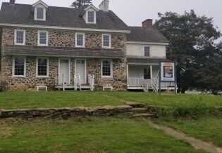
740 Tanguy Rd, Cheyney, PA 19319

NEARBY LISTINGS FOR SALE OR LEASE
Property Detail
740 Tanguy Rd
44-00-00336-00
BLDGS
Publicschool
Delaware
AE
Pennsylvania
42029C0265G
107.88 AC
2024
Delaware County
2025
Philadelphia
410101
Philadelphia-Camden-Wilmington, PA-NJ-DE-MD
59,594 SF
DEMOGRAPHICS near 740 Tanguy Rd
1 Mile
3 Mile
5 Mile
2024 Total Population
1,658
34,365
99,372
2029 Population
1,661
35,260
102,424
Pop Growth 2024-2029
+ 0.18%
+ 2.60%
+ 3.07%
Average Age
42
42
42
2024 Total Households
563
13,363
39,431
HH Growth 2024-2029
+ 0.18%
+ 2.99%
+ 3.22%
Median Household Inc
$183,333
$123,708
$106,726
Avg Household Size
2.90
2.50
2.40
2024 Avg HH Vehicles
2.00
2.00
2.00
Median Home Value
$692,722
$499,548
$494,432
Median Year Built
1994
1983
1981
Nearby Places
Map Layers
Map Styles
 Street
 Aerial
- Restaurants
- Banks
- Shops
- Fitness
- Groceries
PUBLIC TRANSPORTATION
COMMUTER RAIL
Wawa (Media/Wawa Line - SEPTA)
DRIVE
WALK
Distance
Wawa (Media/Wawa Line - SEPTA)
12 min
5.8 mi
Elwyn (R3 - Southeastern Pennsylvania Transportation Authority Regional Rail (SEPTA Regional Rail))
DRIVE
WALK
Distance
Elwyn (R3 - Southeastern Pennsylvania Transportation Authority Regional Rail (SEPTA Regional Rail))
15 min
8.7 mi
AIRPORT
Philadelphia International
DRIVE
WALK
Distance
Philadelphia International
35 min
20.1 mi
Freight Ports
Port of Wilmington, RI
DRIVE
WALK
Distance
Port of Wilmington, RI
36 min
18.7 mi
SALE & LEASE HISTORY
LISTING DATE
SALE/LEASE

Feb 25, 2020
For Lease
Nearby Properties
Address
Land Use
TOTAL SIZE
Lot Size
Zoning
Address
Land Use
TOTAL SIZE
Lot Size
Zoning
224,112 SF
259 AC
Address
Land Use
TOTAL SIZE
Lot Size
Zoning
551,882 SF
112.62 AC
AC
Address
Land Use
TOTAL SIZE
Lot Size
Zoning
45,686 SF
14.20 AC
R3
Address
Land Use
TOTAL SIZE
Lot Size
Zoning
5,764 SF
762.50 AC
Address
Land Use
TOTAL SIZE
Lot Size
Zoning
511,062 SF
170.50 AC
AC
Address
Land Use
TOTAL SIZE
Lot Size
Zoning
391,099 SF
46.85 AC
R1
Address
Land Use
TOTAL SIZE
Lot Size
Zoning
258,232 SF
14.66 AC
B
Address
Land Use
TOTAL SIZE
Lot Size
Zoning
197,949 SF
21.70 AC
R3
Address
Land Use
TOTAL SIZE
Lot Size
Zoning
4,800 SF
27 AC
Address
Land Use
TOTAL SIZE
Lot Size
Zoning
164,500 SF
15 AC
Address
Land Use
TOTAL SIZE
Lot Size
Zoning
194,053 SF
81.20 AC
A2
Address
Land Use
TOTAL SIZE
Lot Size
Zoning
67,218 SF
4.03 AC
Address
Land Use
TOTAL SIZE
Lot Size
Zoning
216,465 SF
13.80 AC
R2
Address
Land Use
TOTAL SIZE
Lot Size
Zoning
123,540 SF
10 AC
C1
Address
Land Use
TOTAL SIZE
Lot Size
Zoning
174,712 SF
14.60 AC
R4
Address
Land Use
TOTAL SIZE
Lot Size
Zoning
203,774 SF
18.75 AC
R5
Address
Land Use
TOTAL SIZE
Lot Size
Zoning
71,888 SF
18.20 AC
R1
Address
Land Use
TOTAL SIZE
Lot Size
Zoning
127,402 SF
18.45 AC
C1
Address
Land Use
TOTAL SIZE
Lot Size
Zoning
68,737 SF
8.49 AC
RA1
Address
Land Use
TOTAL SIZE
Lot Size
Zoning
108,224 SF
19.90 AC
A2
Address
Land Use
TOTAL SIZE
Lot Size
Zoning
116,015 SF
39.50 AC
A2
Address
Land Use
TOTAL SIZE
Lot Size
Zoning
94,089 SF
6.82 AC
C2
Address
Land Use
TOTAL SIZE
Lot Size
Zoning
191,158 SF
9.90 AC
R4
Address
Land Use
TOTAL SIZE
Lot Size
Zoning
63,447 SF
16.10 AC
R1
Address
Land Use
TOTAL SIZE
Lot Size
Zoning
70,237 SF
11 AC
R1
Address
Land Use
TOTAL SIZE
Lot Size
Zoning
125,725 SF
10.80 AC
Address
Land Use
TOTAL SIZE
Lot Size
Zoning
65,858 SF
6.20 AC
R2
Address
Land Use
TOTAL SIZE
Lot Size
Zoning
78,916 SF
9.60 AC
C1
Address
Land Use
TOTAL SIZE
Lot Size
Zoning
85,880 SF
19.20 AC
A2
The World's #1 Commercial Real Estate Marketplace
Connect with us
© 2026 CoStar Group
The information above has been obtained from sources believed reliable. While we do not doubt its accuracy we have not verified it and make no guarantee, warranty or representation about it. It is your responsibility to independently confirm its accuracy and completeness. Any projections, opinions, assumptions, or estimates used are for example only and do not represent the current or future performance of the property. The value of this transaction to you depends on tax and other factors which should be evaluated by your tax, financial, and legal advisors. You and your advisors should conduct a careful, independent investigation of the property to determine to your satisfaction the suitability of the property for your needs.