Property Record
740 W Route 73 Ave, Springboro, OH 45066

NEARBY LISTINGS FOR SALE OR LEASE
Property Detail
740 W Route 73 Ave
04-20-402-011
Route 73
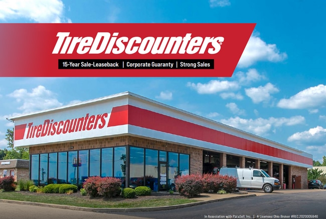
Autorepair
ROUTE 73
X
Warren
39165C0009E
Ohio
2024
1 AC
2024
Outlying Warren County
030504
Cincinnati/Dayton
5,434 SF
Cincinnati, OH-KY-IN
DEMOGRAPHICS near 740 W Route 73 Ave
1 Mile
3 Mile
5 Mile
2024 Total Population
3,447
37,337
87,607
2029 Population
3,748
40,077
92,278
Pop Growth 2024-2029
+ 8.73%
+ 7.34%
+ 5.33%
Average Age
42
40
41
2024 Total Households
1,370
14,442
34,379
HH Growth 2024-2029
+ 8.83%
+ 7.44%
+ 5.08%
Median Household Inc
$84,312
$84,596
$90,573
Avg Household Size
2.50
2.50
2.50
2024 Avg HH Vehicles
2.00
2.00
2.00
Median Home Value
$184,349
$220,963
$239,920
Median Year Built
1975
1982
1989
Nearby Places
Map Layers
Map Styles
 Street
 Aerial
- Restaurants
- Banks
- Shops
- Fitness
- Groceries
PUBLIC TRANSPORTATION
AIRPORT
James M Cox Dayton International
DRIVE
WALK
Distance
James M Cox Dayton International
38 min
28.1 mi
Freight Ports
Port of Toledo
DRIVE
WALK
Distance
Port of Toledo
195 min
168.3 mi
SALE & LEASE HISTORY
LISTING DATE
SALE/LEASE

Sep 05, 2023
For Sale
Nearby Properties
Address
Land Use
TOTAL SIZE
Lot Size
Zoning
Address
Land Use
TOTAL SIZE
Lot Size
Zoning
11,684 SF
16.01 AC
Address
Land Use
TOTAL SIZE
Lot Size
Zoning
446,592 SF
4.33 AC
Address
Land Use
TOTAL SIZE
Lot Size
Zoning
142,758 SF
11.15 AC
Address
Land Use
TOTAL SIZE
Lot Size
Zoning
6,048 SF
51.16 AC
Address
Land Use
TOTAL SIZE
Lot Size
Zoning
266,231 SF
17.07 AC
Address
Land Use
TOTAL SIZE
Lot Size
Zoning
507,846 SF
23.90 AC
Address
Land Use
TOTAL SIZE
Lot Size
Zoning
39,404 SF
55.59 AC
Address
Land Use
TOTAL SIZE
Lot Size
Zoning
36,570 SF
20.29 AC
Address
Land Use
TOTAL SIZE
Lot Size
Zoning
13.24 AC
Address
Land Use
TOTAL SIZE
Lot Size
Zoning
56.81 AC
R1
Address
Land Use
TOTAL SIZE
Lot Size
Zoning
20,093 SF
11.15 AC
Address
Land Use
TOTAL SIZE
Lot Size
Zoning
15,559 SF
40.01 AC
Address
Land Use
TOTAL SIZE
Lot Size
Zoning
11,260 SF
6.32 AC
Address
Land Use
TOTAL SIZE
Lot Size
Zoning
122,344 SF
2.17 AC
Address
Land Use
TOTAL SIZE
Lot Size
Zoning
81,259 SF
63.28 AC
Address
Land Use
TOTAL SIZE
Lot Size
Zoning
120,000 SF
11.52 AC
Address
Land Use
TOTAL SIZE
Lot Size
Zoning
55,611 SF
9.56 AC
Address
Land Use
TOTAL SIZE
Lot Size
Zoning
122,344 SF
4.10 AC
Address
Land Use
TOTAL SIZE
Lot Size
Zoning
11,847 SF
5.96 AC
Address
Land Use
TOTAL SIZE
Lot Size
Zoning
70,217 SF
12.25 AC
Address
Land Use
TOTAL SIZE
Lot Size
Zoning
32,550 SF
26.11 AC
Address
Land Use
TOTAL SIZE
Lot Size
Zoning
1,848 SF
50.22 AC
Address
Land Use
TOTAL SIZE
Lot Size
Zoning
487,924 SF
22.33 AC
Address
Land Use
TOTAL SIZE
Lot Size
Zoning
85,514 SF
3.20 AC
Address
Land Use
TOTAL SIZE
Lot Size
Zoning
217,679 SF
25.16 AC
Address
Land Use
TOTAL SIZE
Lot Size
Zoning
18.89 AC
Address
Land Use
TOTAL SIZE
Lot Size
Zoning
74,368 SF
10 AC
Address
Land Use
TOTAL SIZE
Lot Size
Zoning
26,459 SF
6.95 AC
Address
Land Use
TOTAL SIZE
Lot Size
Zoning
80,388 SF
2.36 AC
Address
Land Use
TOTAL SIZE
Lot Size
Zoning
16,174 SF
0.79 AC
The World's #1 Commercial Real Estate Marketplace
Connect with us
© 2026 CoStar Group
The information above has been obtained from sources believed reliable. While we do not doubt its accuracy we have not verified it and make no guarantee, warranty or representation about it. It is your responsibility to independently confirm its accuracy and completeness. Any projections, opinions, assumptions, or estimates used are for example only and do not represent the current or future performance of the property. The value of this transaction to you depends on tax and other factors which should be evaluated by your tax, financial, and legal advisors. You and your advisors should conduct a careful, independent investigation of the property to determine to your satisfaction the suitability of the property for your needs.