Property Record
740 Williams St, Pittsfield, MA 01201

Save to a Folder
{{folder.Name}}
{{folder.ListingIds.length}} Properties
{{folder.ListingIds.length}} Property
Create a New Folder
Property Detail
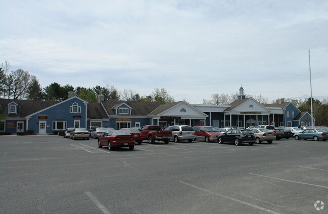
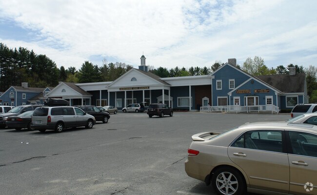
740 Williams St
PITT-000007L-000002-000201
Berkshire
Regionalshoppingcenterormallwithanchorstore
Massachusetts
BC
201
2025
2.88 AC
2025
Massachusetts North/West Area
900800
Other Market Areas
34,300 SF
Pittsfield, MA
NEARBY LISTINGS FOR SALE OR LEASE
DEMOGRAPHICS near 740 Williams St
1 mile
3 mile
5 mile
2025 Total Population
3,435
28,590
47,646
2030 Population
3,298
27,618
46,259
Pop Growth 2025-2030
(3.99%)
(3.40%)
(2.91%)
Average Age
46
44
45
2025 Total Households
1,498
13,013
21,139
HH Growth 2025-2030
(3.87%)
(3.31%)
(2.90%)
Median Household Inc
$85,057
$66,747
$73,014
Avg Household Size
2.30
2.10
2.10
2025 Avg HH Vehicles
1.00
1.00
1.00
Median Home Value
$265,743
$264,091
$263,875
Median Year Built
1956
1948
1950
Nearby Places
Map Layers
Map Styles
 Street
 Aerial
Layers
 Traffic
 Biking
Places
Listings with unknown addresses are not visible on the map
- Restaurants
- Banks
- Shops
- Fitness
- Groceries
PUBLIC TRANSPORTATION
COMMUTER RAIL
Drive
Walk
Distance
8 min
2.9 mi
AIRPORT
Albany International
Drive
Walk
Distance
Albany International
79 min
48.0 mi
Freight Ports
Albany, NY Port
Drive
Walk
Distance
Albany, NY Port
69 min
42.6 mi
Nearby Properties
Address
Land Use
TOTAL SIZE
Lot Size
Zoning
Address
Land Use
TOTAL SIZE
Lot Size
Zoning
8.36 AC
BG
Address
Land Use
TOTAL SIZE
Lot Size
Zoning
284,301 SF
8.70 AC
DCD
Address
Land Use
TOTAL SIZE
Lot Size
Zoning
Address
Land Use
TOTAL SIZE
Lot Size
Zoning
6.15 AC
IG
Address
Land Use
TOTAL SIZE
Lot Size
Zoning
14.63 AC
IG
Address
Land Use
TOTAL SIZE
Lot Size
Zoning
165,400 SF
0.49 AC
IG
Address
Land Use
TOTAL SIZE
Lot Size
Zoning
334,640 SF
2.41 AC
DCD
Address
Land Use
TOTAL SIZE
Lot Size
Zoning
237.50 AC
R6
Address
Land Use
TOTAL SIZE
Lot Size
Zoning
21 AC
R12
Address
Land Use
TOTAL SIZE
Lot Size
Zoning
75.30 AC
R43
Address
Land Use
TOTAL SIZE
Lot Size
Zoning
41,395 SF
0.98 AC
BG
Address
Land Use
TOTAL SIZE
Lot Size
Zoning
2,295.68 AC
R1
Address
Land Use
TOTAL SIZE
Lot Size
Zoning
2.38 AC
DCD
Address
Land Use
TOTAL SIZE
Lot Size
Zoning
1.30 AC
DCD
Address
Land Use
TOTAL SIZE
Lot Size
Zoning
87,081 SF
11.50 AC
IG
Address
Land Use
TOTAL SIZE
Lot Size
Zoning
29,700 SF
0.56 AC
DCD
Address
Land Use
TOTAL SIZE
Lot Size
Zoning
242,525 SF
12.52 AC
BC
Address
Land Use
TOTAL SIZE
Lot Size
Zoning
128,036 SF
14.92 AC
IG
Address
Land Use
TOTAL SIZE
Lot Size
Zoning
79,095 SF
14.89 AC
IG
Address
Land Use
TOTAL SIZE
Lot Size
Zoning
183,260 SF
6 AC
IG
Address
Land Use
TOTAL SIZE
Lot Size
Zoning
17.26 AC
BG
Address
Land Use
TOTAL SIZE
Lot Size
Zoning
11.77 AC
IG
Address
Land Use
TOTAL SIZE
Lot Size
Zoning
37,551 SF
6.50 AC
R6
Address
Land Use
TOTAL SIZE
Lot Size
Zoning
102,954 SF
11.98 AC
IG
Address
Land Use
TOTAL SIZE
Lot Size
Zoning
49,209 SF
2.66 AC
RM
Address
Land Use
TOTAL SIZE
Lot Size
Zoning
225,775 SF
1.57 AC
BG
Address
Land Use
TOTAL SIZE
Lot Size
Zoning
82,160 SF
5.40 AC
RM
Address
Land Use
TOTAL SIZE
Lot Size
Zoning
35 AC
RG
Address
Land Use
TOTAL SIZE
Lot Size
Zoning
106,353 SF
0.91 AC
DCD
Address
Land Use
TOTAL SIZE
Lot Size
Zoning
6.30 AC
RM
The World's #1 Commercial Real Estate Marketplace
Connect with us
© 2026 CoStar Group
The information above has been obtained from sources believed reliable. While we do not doubt its accuracy we have not verified it and make no guarantee, warranty or representation about it. It is your responsibility to independently confirm its accuracy and completeness. Any projections, opinions, assumptions, or estimates used are for example only and do not represent the current or future performance of the property. The value of this transaction to you depends on tax and other factors which should be evaluated by your tax, financial, and legal advisors. You and your advisors should conduct a careful, independent investigation of the property to determine to your satisfaction the suitability of the property for your needs.