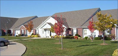
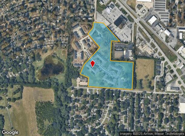
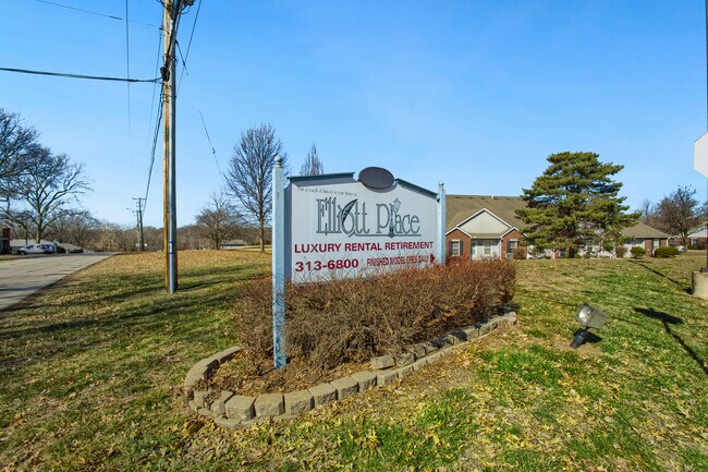
Property Record
7400 Maple Dr, Raytown, MO 64133
NEARBY LISTINGS FOR SALE OR LEASE
-
-
View all Raytown listings for sale on LoopNet.com
Property Detail
7400 Maple Dr
45-540-03-57-00-0-00-000
SEC-08 TWP-48 RNG-32---PT SW 1/4 SE 1/4 DAF: BEG SW COR LOT 14 CENCI HEIGHTS TH N 89 DEG 54 MIN 26 SEC E 484.62 TO TRU POB TH S 01 DEG 09 MIN 30 SEC E 106.23 TH S 36 DEG 20 MIN 4
Retirementnursinghomecombined
Jackson
X
Missouri
29095C0401G
14
2024
18.22 AC
2025
Raytown
012803
Kansas City
37,401 SF
Kansas City, MO-KS
DEMOGRAPHICS near 7400 Maple Dr
1 mile
3 mile
5 mile
2024 Total Population
8,026
50,914
117,216
2029 Population
7,957
50,455
117,018
Pop Growth 2024-2029
(0.86%)
(0.90%)
(0.17%)
Average Age
41
41
40
2024 Total Households
3,431
20,998
47,950
HH Growth 2024-2029
(0.93%)
(1.07%)
(0.29%)
Median Household Inc
$58,348
$59,760
$55,965
Avg Household Size
2.30
2.30
2.30
2024 Avg HH Vehicles
2.00
2.00
2.00
Median Home Value
$137,074
$153,423
$155,504
Median Year Built
1960
1965
1966
Nearby Places
Map Layers
Map Styles
 Street
 Aerial
Transit
 Traffic
 Biking
Places
Listings with unknown addresses are not visible on the map
- Restaurants
- Banks
- Shops
- Fitness
- Groceries
PUBLIC TRANSPORTATION
COMMUTER RAIL
Lee's Summit Amtrak (Lincoln Service Missouri River Runner - Amtrak, Missouri River Runner - Amtrak)
Drive
Walk
Distance
Lee's Summit Amtrak (Lincoln Service Missouri River Runner - Amtrak, Missouri River Runner - Amtrak)
15 min
8.5 mi
AIRPORT
Kansas City International
Drive
Walk
Distance
Kansas City International
46 min
35.1 mi
Freight Ports
Tulsa Port Of Catoosa
Drive
Walk
Distance
Tulsa Port Of Catoosa
267 min
235.3 mi
SALE & LEASE HISTORY
LISTING DATE
SALE/LEASE

Apr 17, 2025
For Sale
Nearby Properties
Address
Land Use
TOTAL SIZE
Lot Size
Zoning
Address
Land Use
TOTAL SIZE
Lot Size
Zoning
112,500 SF
26.32 AC
Address
Land Use
TOTAL SIZE
Lot Size
Zoning
246,115 SF
Address
Land Use
TOTAL SIZE
Lot Size
Zoning
175,318 SF
26.37 AC
Address
Land Use
TOTAL SIZE
Lot Size
Zoning
137,428 SF
27.76 AC
Address
Land Use
TOTAL SIZE
Lot Size
Zoning
168,184 SF
18.63 AC
Address
Land Use
TOTAL SIZE
Lot Size
Zoning
389,227 SF
33.30 AC
Address
Land Use
TOTAL SIZE
Lot Size
Zoning
134,082 SF
1.79 AC
Address
Land Use
TOTAL SIZE
Lot Size
Zoning
34,832 SF
8.29 AC
Address
Land Use
TOTAL SIZE
Lot Size
Zoning
173,321 SF
40 AC
Address
Land Use
TOTAL SIZE
Lot Size
Zoning
82,607 SF
9.90 AC
Address
Land Use
TOTAL SIZE
Lot Size
Zoning
42,417 SF
21.81 AC
Address
Land Use
TOTAL SIZE
Lot Size
Zoning
Address
Land Use
TOTAL SIZE
Lot Size
Zoning
16,764 SF
154.60 AC
Address
Land Use
TOTAL SIZE
Lot Size
Zoning
33,541 SF
21.83 AC
Address
Land Use
TOTAL SIZE
Lot Size
Zoning
80,433 SF
7.24 AC
Address
Land Use
TOTAL SIZE
Lot Size
Zoning
176,132 SF
0.27 AC
Address
Land Use
TOTAL SIZE
Lot Size
Zoning
73,434 SF
10.35 AC
Address
Land Use
TOTAL SIZE
Lot Size
Zoning
47,537 SF
15.70 AC
Address
Land Use
TOTAL SIZE
Lot Size
Zoning
85,700 SF
21.88 AC
Address
Land Use
TOTAL SIZE
Lot Size
Zoning
43,200 SF
4.37 AC
Address
Land Use
TOTAL SIZE
Lot Size
Zoning
35,646 SF
3.25 AC
Address
Land Use
TOTAL SIZE
Lot Size
Zoning
67,570 SF
5.71 AC
Address
Land Use
TOTAL SIZE
Lot Size
Zoning
47,099 SF
3.55 AC
Address
Land Use
TOTAL SIZE
Lot Size
Zoning
22,913 SF
151.50 AC
Address
Land Use
TOTAL SIZE
Lot Size
Zoning
12,382 SF
1 AC
Address
Land Use
TOTAL SIZE
Lot Size
Zoning
49,839 SF
2.97 AC
Address
Land Use
TOTAL SIZE
Lot Size
Zoning
143,803 SF
9.17 AC
Address
Land Use
TOTAL SIZE
Lot Size
Zoning
36,220 SF
6.61 AC
Address
Land Use
TOTAL SIZE
Lot Size
Zoning
60,372 SF
12.37 AC
The World's #1 Commercial Real Estate Marketplace
Connect with us
© 2026 CoStar Group
The information above has been obtained from sources believed reliable. While we do not doubt its accuracy we have not verified it and make no guarantee, warranty or representation about it. It is your responsibility to independently confirm its accuracy and completeness. Any projections, opinions, assumptions, or estimates used are for example only and do not represent the current or future performance of the property. The value of this transaction to you depends on tax and other factors which should be evaluated by your tax, financial, and legal advisors. You and your advisors should conduct a careful, independent investigation of the property to determine to your satisfaction the suitability of the property for your needs.