Property Record
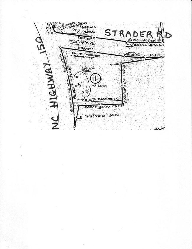
7400 Strader Rd, Summerfield, NC 27358

NEARBY LISTINGS FOR SALE OR LEASE
Property Detail
7400 Strader Rd
Greensboro/Winston-Salem
Lois Warner Estates
Greensboro-High Point, NC
Guilford
0148010
North Carolina
Residentialnec
1.01 AC
X
NW Guilford County
3710784900J
DEMOGRAPHICS near 7400 Strader Rd
1 Mile
3 Mile
5 Mile
2024 Total Population
1,448
9,299
46,392
2029 Population
1,431
9,244
46,103
Pop Growth 2024-2029
(1.17%)
(0.59%)
(0.62%)
Average Age
42
41
41
2024 Total Households
505
3,293
18,909
HH Growth 2024-2029
(1.19%)
(0.61%)
(0.68%)
Median Household Inc
$145,981
$132,335
$94,649
Avg Household Size
2.80
2.80
2.40
2024 Avg HH Vehicles
3.00
2.00
2.00
Median Home Value
$432,673
$431,158
$328,722
Median Year Built
1997
1998
1994
Nearby Places
Map Layers
Map Styles
 Street
 Aerial
- Restaurants
- Banks
- Shops
- Fitness
- Groceries
PUBLIC TRANSPORTATION
AIRPORT
Piedmont Triad International
DRIVE
WALK
Distance
Piedmont Triad International
23 min
12.3 mi
SALE & LEASE HISTORY
LISTING DATE
SALE/LEASE

Nov 11, 2022
For Sale
Nearby Properties
Address
Land Use
TOTAL SIZE
Lot Size
Zoning
Address
Land Use
TOTAL SIZE
Lot Size
Zoning
134,391 SF
19 AC
O
Address
Land Use
TOTAL SIZE
Lot Size
Zoning
1,128.32 AC
R-3
Address
Land Use
TOTAL SIZE
Lot Size
Zoning
54,260 SF
18.91 AC
RS-30
Address
Land Use
TOTAL SIZE
Lot Size
Zoning
24,910 SF
96.01 AC
PI
Address
Land Use
TOTAL SIZE
Lot Size
Zoning
90,000 SF
5.46 AC
LI
Address
Land Use
TOTAL SIZE
Lot Size
Zoning
52,167 SF
27.97 AC
RS-30
Address
Land Use
TOTAL SIZE
Lot Size
Zoning
38,926 SF
25.65 AC
GB
Address
Land Use
TOTAL SIZE
Lot Size
Zoning
4,511 SF
463.69 AC
AG
Address
Land Use
TOTAL SIZE
Lot Size
Zoning
2,191 SF
43.13 AC
GB
Address
Land Use
TOTAL SIZE
Lot Size
Zoning
56,095 SF
26.64 AC
PI
Address
Land Use
TOTAL SIZE
Lot Size
Zoning
42,298 SF
4.94 AC
HB
Address
Land Use
TOTAL SIZE
Lot Size
Zoning
14,676 SF
2.31 AC
HB
Address
Land Use
TOTAL SIZE
Lot Size
Zoning
17,640 SF
16.59 AC
AG-SP
Address
Land Use
TOTAL SIZE
Lot Size
Zoning
280.47 AC
R-3
Address
Land Use
TOTAL SIZE
Lot Size
Zoning
20,939 SF
4.61 AC
PI
Address
Land Use
TOTAL SIZE
Lot Size
Zoning
5,913 SF
5.61 AC
RS-30
Address
Land Use
TOTAL SIZE
Lot Size
Zoning
13,547 SF
11.95 AC
HB
Address
Land Use
TOTAL SIZE
Lot Size
Zoning
2,097 SF
145.27 AC
AG
Address
Land Use
TOTAL SIZE
Lot Size
Zoning
14,442 SF
7.96 AC
R-3
Address
Land Use
TOTAL SIZE
Lot Size
Zoning
10,502 SF
1.44 AC
LB
Address
Land Use
TOTAL SIZE
Lot Size
Zoning
34,903 SF
11.17 AC
PI
Address
Land Use
TOTAL SIZE
Lot Size
Zoning
3,638 SF
149.60 AC
AG
Address
Land Use
TOTAL SIZE
Lot Size
Zoning
45,131 SF
8.37 AC
AG
Address
Land Use
TOTAL SIZE
Lot Size
Zoning
972 SF
134.05 AC
AG
Address
Land Use
TOTAL SIZE
Lot Size
Zoning
9,831 SF
5 AC
LO
Address
Land Use
TOTAL SIZE
Lot Size
Zoning
850 SF
140.07 AC
RS-40
Address
Land Use
TOTAL SIZE
Lot Size
Zoning
21.17 AC
GB
Address
Land Use
TOTAL SIZE
Lot Size
Zoning
3,881 SF
94.81 AC
AG
Address
Land Use
TOTAL SIZE
Lot Size
Zoning
3,025 SF
92.54 AC
AG
Address
Land Use
TOTAL SIZE
Lot Size
Zoning
5,386 SF
55.16 AC
AG
The World's #1 Commercial Real Estate Marketplace
Connect with us
© 2026 CoStar Group
The information above has been obtained from sources believed reliable. While we do not doubt its accuracy we have not verified it and make no guarantee, warranty or representation about it. It is your responsibility to independently confirm its accuracy and completeness. Any projections, opinions, assumptions, or estimates used are for example only and do not represent the current or future performance of the property. The value of this transaction to you depends on tax and other factors which should be evaluated by your tax, financial, and legal advisors. You and your advisors should conduct a careful, independent investigation of the property to determine to your satisfaction the suitability of the property for your needs.