Property Record
7400 W 37Th St N, Wichita, KS 67205
NEARBY LISTINGS FOR SALE OR LEASE
Property Detail
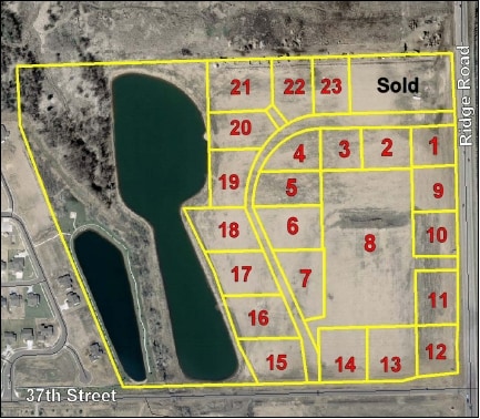
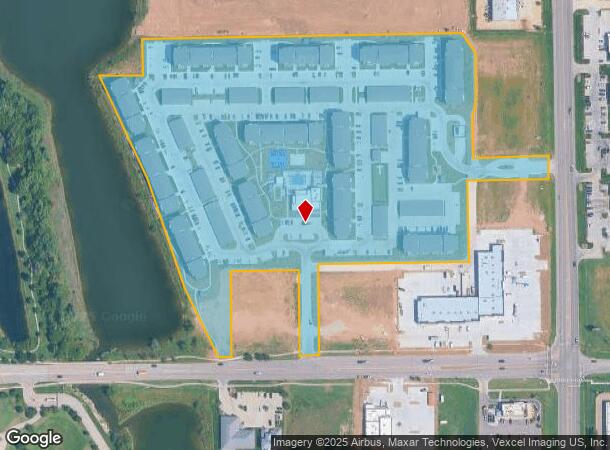
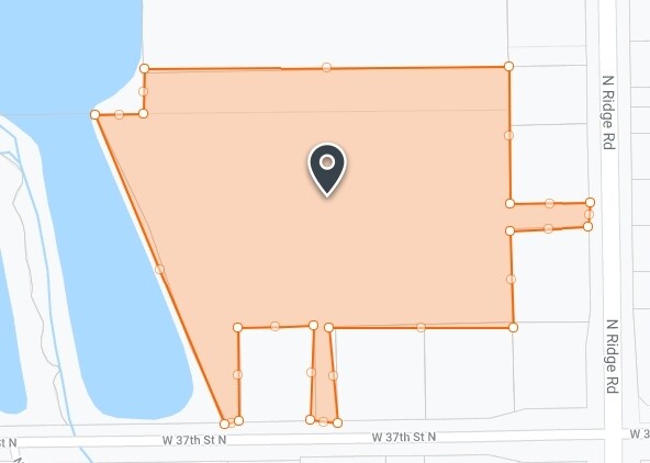
7400 W 37Th St N
Wichita, KS
Said Add
088-28-0-44-01-006.00
LOT 1 EXC BEG SW COR LOT 6 BLOCK A TH W 13 FT N 123 FT NELY 46.36 FT TO PT W LI LOT 6 TH S 167.5 FT TO BEG & EXC TH PT BEG NW COR LOT 7 BLOCK A S 265 FT NW COR LOT 8 BLOCK A TH W 498.88 FT NW COR LOT 10 TH N 15 FT E 468.84 FT N 249.92 FT E 30 FT TO B
Apartment
Sedgwick
AE
Kansas
20173C0193G
1,6
2024
18.11 AC
2025
Outlying Sedgwick County
010301
Wichita
68,496 SF
DEMOGRAPHICS near 7400 W 37Th St N
1 Mile
3 Mile
5 Mile
2024 Total Population
5,181
32,246
102,934
2029 Population
5,326
32,833
104,435
Pop Growth 2024-2029
+ 2.80%
+ 1.82%
+ 1.46%
Average Age
38
39
40
2024 Total Households
1,790
11,701
41,305
HH Growth 2024-2029
+ 2.91%
+ 1.76%
+ 1.46%
Median Household Inc
$111,400
$90,516
$66,363
Avg Household Size
2.80
2.70
2.40
2024 Avg HH Vehicles
2.00
2.00
2.00
Median Home Value
$261,546
$252,533
$188,420
Median Year Built
2007
2000
1982
Nearby Places
Map Layers
Map Styles
 Street
 Aerial
- Restaurants
- Banks
- Shops
- Fitness
- Groceries
PUBLIC TRANSPORTATION
AIRPORT
Wichita Dwight D Eisenhower Ntl
DRIVE
WALK
Distance
Wichita Dwight D Eisenhower Ntl
14 min
7.1 mi
Freight Ports
Tulsa Port Of Catoosa
DRIVE
WALK
Distance
Tulsa Port Of Catoosa
215 min
200.5 mi
Nearby Properties
Address
Land Use
TOTAL SIZE
Lot Size
Zoning
Address
Land Use
TOTAL SIZE
Lot Size
Zoning
662,237 SF
179.74 AC
SF-5
Address
Land Use
TOTAL SIZE
Lot Size
Zoning
216,196 SF
65.60 AC
SF-5
Address
Land Use
TOTAL SIZE
Lot Size
Zoning
558,228 SF
126.95 AC
SF-5
Address
Land Use
TOTAL SIZE
Lot Size
Zoning
108,480 SF
14.90 AC
GO
Address
Land Use
TOTAL SIZE
Lot Size
Zoning
192,027 SF
117.94 AC
SF-20,GC,L
Address
Land Use
TOTAL SIZE
Lot Size
Zoning
175,639 SF
22.91 AC
SF-5
Address
Land Use
TOTAL SIZE
Lot Size
Zoning
104,252 SF
7.24 AC
SF-5
Address
Land Use
TOTAL SIZE
Lot Size
Zoning
99,933 SF
9.98 AC
SF-5
Address
Land Use
TOTAL SIZE
Lot Size
Zoning
74,378 SF
14.63 AC
GO
Address
Land Use
TOTAL SIZE
Lot Size
Zoning
89,126 SF
34.29 AC
R6
Address
Land Use
TOTAL SIZE
Lot Size
Zoning
56,519 SF
84.45 AC
SF-20,LI
Address
Land Use
TOTAL SIZE
Lot Size
Zoning
38,927 SF
5 AC
LC
Address
Land Use
TOTAL SIZE
Lot Size
Zoning
77,159 SF
5.97 AC
SF-5
Address
Land Use
TOTAL SIZE
Lot Size
Zoning
84,317 SF
7.18 AC
SF-5
Address
Land Use
TOTAL SIZE
Lot Size
Zoning
29,952 SF
3.98 AC
GO
Address
Land Use
TOTAL SIZE
Lot Size
Zoning
173,604 SF
21.29 AC
LC
Address
Land Use
TOTAL SIZE
Lot Size
Zoning
47,158 SF
211.18 AC
SF-20,LC
Address
Land Use
TOTAL SIZE
Lot Size
Zoning
34,963 SF
6.13 AC
Address
Land Use
TOTAL SIZE
Lot Size
Zoning
24,134 SF
8.78 AC
B1
Address
Land Use
TOTAL SIZE
Lot Size
Zoning
36,818 SF
14.91 AC
SF-5
Address
Land Use
TOTAL SIZE
Lot Size
Zoning
94,866 SF
7.40 AC
LC
Address
Land Use
TOTAL SIZE
Lot Size
Zoning
39,299 SF
4.82 AC
SF-5
Address
Land Use
TOTAL SIZE
Lot Size
Zoning
18,125 SF
5.91 AC
SF-5
Address
Land Use
TOTAL SIZE
Lot Size
Zoning
14,370 SF
5.30 AC
OW
Address
Land Use
TOTAL SIZE
Lot Size
Zoning
90,279 SF
11.70 AC
LC
Address
Land Use
TOTAL SIZE
Lot Size
Zoning
70,160 SF
13.48 AC
AA
Address
Land Use
TOTAL SIZE
Lot Size
Zoning
19,148 SF
4.46 AC
LI
Address
Land Use
TOTAL SIZE
Lot Size
Zoning
22,644 SF
3.50 AC
Address
Land Use
TOTAL SIZE
Lot Size
Zoning
171,301 SF
22.05 AC
The World's #1 Commercial Real Estate Marketplace
Connect with us
© 2026 CoStar Group
The information above has been obtained from sources believed reliable. While we do not doubt its accuracy we have not verified it and make no guarantee, warranty or representation about it. It is your responsibility to independently confirm its accuracy and completeness. Any projections, opinions, assumptions, or estimates used are for example only and do not represent the current or future performance of the property. The value of this transaction to you depends on tax and other factors which should be evaluated by your tax, financial, and legal advisors. You and your advisors should conduct a careful, independent investigation of the property to determine to your satisfaction the suitability of the property for your needs.