Property Record
7401 Andrews Hwy, Odessa, TX 79765
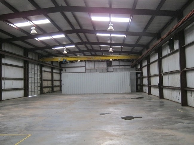
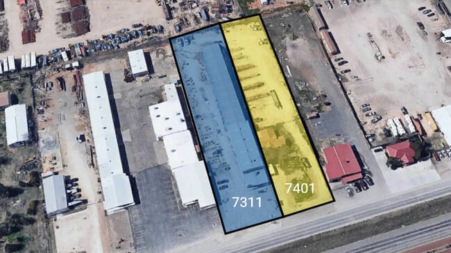
This Property Is For Sale
NEARBY LISTINGS FOR SALE OR LEASE
Property Detail
7401 Andrews Hwy
21100-00221-00000
North Gate
Sfr
NORTH GATE TRACT 18 (CARD #16)
X
Ector
48135C0220E
Texas
2025
1 AC
2025
Midland & Odessa
000100
Other Market Areas
1,196 SF
Odessa, TX
DEMOGRAPHICS near 7401 Andrews Hwy
1 Mile
3 Mile
5 Mile
2024 Total Population
2,202
39,547
89,296
2029 Population
2,366
42,272
95,008
Pop Growth 2024-2029
+ 7.45%
+ 6.89%
+ 6.40%
Average Age
37
34
35
2024 Total Households
857
14,070
31,973
HH Growth 2024-2029
+ 8.63%
+ 8.00%
+ 7.56%
Median Household Inc
$52,359
$72,793
$67,878
Avg Household Size
2.50
2.70
2.70
2024 Avg HH Vehicles
2.00
2.00
2.00
Median Home Value
$116,935
$223,059
$204,601
Median Year Built
1985
1985
1974
Nearby Places
- Restaurants
- Banks
- Shops
- Fitness
- Groceries
PUBLIC TRANSPORTATION
AIRPORT
Midland International Air And Space Port
DRIVE
WALK
Distance
Midland International Air And Space Port
24 min
16.3 mi
Freight Ports
Port of Corpus Christi
DRIVE
WALK
Distance
Port of Corpus Christi
510 min
489.2 mi
Nearby Properties
Address
Land Use
TOTAL SIZE
Lot Size
Zoning
Address
Land Use
TOTAL SIZE
Lot Size
Zoning
54,990 SF
46.21 AC
ED5
Address
Land Use
TOTAL SIZE
Lot Size
Zoning
295,840 SF
12.04 AC
EC1
Address
Land Use
TOTAL SIZE
Lot Size
Zoning
2,268 SF
15.91 AC
EB2
Address
Land Use
TOTAL SIZE
Lot Size
Zoning
136,794 SF
631.22 AC
EC3
Address
Land Use
TOTAL SIZE
Lot Size
Zoning
197,580 SF
8.77 AC
ED3
Address
Land Use
TOTAL SIZE
Lot Size
Zoning
155,744 SF
49.20 AC
EA7
Address
Land Use
TOTAL SIZE
Lot Size
Zoning
106,812 SF
28 AC
EC2
Address
Land Use
TOTAL SIZE
Lot Size
Zoning
348,480 SF
82.30 AC
EC4
Address
Land Use
TOTAL SIZE
Lot Size
Zoning
5,682 SF
9.17 AC
EC1
Address
Land Use
TOTAL SIZE
Lot Size
Zoning
2,978 SF
56 AC
ED2
Address
Land Use
TOTAL SIZE
Lot Size
Zoning
64,691 SF
9.90 AC
EC1
Address
Land Use
TOTAL SIZE
Lot Size
Zoning
146,559 SF
15.96 AC
ED4
Address
Land Use
TOTAL SIZE
Lot Size
Zoning
16,800 SF
91.80 AC
EA7
Address
Land Use
TOTAL SIZE
Lot Size
Zoning
2,720 SF
4.05 AC
ED2
Address
Land Use
TOTAL SIZE
Lot Size
Zoning
3,645 SF
6.08 AC
ED2
Address
Land Use
TOTAL SIZE
Lot Size
Zoning
5,120 SF
209.81 AC
EC4
Address
Land Use
TOTAL SIZE
Lot Size
Zoning
61,004 SF
11.89 AC
ED2
Address
Land Use
TOTAL SIZE
Lot Size
Zoning
12,404 SF
9.41 AC
EC4
Address
Land Use
TOTAL SIZE
Lot Size
Zoning
59,304 SF
11.83 AC
ED2
Address
Land Use
TOTAL SIZE
Lot Size
Zoning
36,543 SF
11.50 AC
EC1
Address
Land Use
TOTAL SIZE
Lot Size
Zoning
70,873 SF
6.39 AC
ED1
Address
Land Use
TOTAL SIZE
Lot Size
Zoning
7,680 SF
5.41 AC
ED3
Address
Land Use
TOTAL SIZE
Lot Size
Zoning
2,163 SF
4.96 AC
ED2
Address
Land Use
TOTAL SIZE
Lot Size
Zoning
160 AC
EC4
Address
Land Use
TOTAL SIZE
Lot Size
Zoning
31,200 SF
2.44 AC
EA6
Address
Land Use
TOTAL SIZE
Lot Size
Zoning
52,800 SF
9.16 AC
EA2
Address
Land Use
TOTAL SIZE
Lot Size
Zoning
28,800 SF
5.08 AC
EA2
Address
Land Use
TOTAL SIZE
Lot Size
Zoning
53,127 SF
10.24 AC
ED1
Address
Land Use
TOTAL SIZE
Lot Size
Zoning
11,250 SF
10.15 AC
EA2
Address
Land Use
TOTAL SIZE
Lot Size
Zoning
62,750 SF
3.55 AC
ED1
The World's #1 Commercial Real Estate Marketplace
Connect with us
© 2025 CoStar Group
The information above has been obtained from sources believed reliable. While we do not doubt its accuracy we have not verified it and make no guarantee, warranty or representation about it. It is your responsibility to independently confirm its accuracy and completeness. Any projections, opinions, assumptions, or estimates used are for example only and do not represent the current or future performance of the property. The value of this transaction to you depends on tax and other factors which should be evaluated by your tax, financial, and legal advisors. You and your advisors should conduct a careful, independent investigation of the property to determine to your satisfaction the suitability of the property for your needs.