Property Record
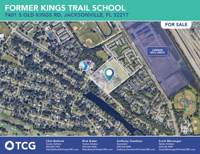
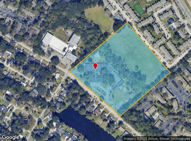
7401 Old Kings Rd S, Jacksonville, FL 32217
This Property Is For Sale
NEARBY LISTINGS FOR SALE OR LEASE
Property Detail
7401 Old Kings Rd S
Jacksonville, FL
Section Land
148000-0000
17-3S-27E PT LOTS 1,2,4 RECD O/R BK 138-410
Publicschool
Duval
X
Florida
12031C0551J
1,2,4
0
12.61 AC
2026
San Marco
016606
Jacksonville (Florida)
51,218 SF
DEMOGRAPHICS near 7401 Old Kings Rd S
1 Mile
3 Mile
5 Mile
2024 Total Population
10,881
67,604
181,630
2029 Population
11,623
71,811
192,604
Pop Growth 2024-2029
+ 6.82%
+ 6.22%
+ 6.04%
Average Age
39
40
39
2024 Total Households
4,511
28,405
78,728
HH Growth 2024-2029
+ 7.09%
+ 6.46%
+ 6.30%
Median Household Inc
$61,617
$68,477
$70,153
Avg Household Size
2.30
2.30
2.20
2024 Avg HH Vehicles
1.00
2.00
2.00
Median Home Value
$301,405
$314,368
$322,852
Median Year Built
1974
1980
1983
Nearby Places
Map Layers
Map Styles
 Street
 Aerial
- Restaurants
- Banks
- Shops
- Fitness
- Groceries
PUBLIC TRANSPORTATION
AIRPORT
Jacksonville International
DRIVE
WALK
Distance
Jacksonville International
36 min
22.9 mi
Freight Ports
Jacksonville Port
DRIVE
WALK
Distance
Jacksonville Port
21 min
11.3 mi
Nearby Properties
Address
Land Use
TOTAL SIZE
Lot Size
Zoning
Address
Land Use
TOTAL SIZE
Lot Size
Zoning
875,866 SF
22.33 AC
PBF-3
Address
Land Use
TOTAL SIZE
Lot Size
Zoning
251,691 SF
17.51 AC
PUD
Address
Land Use
TOTAL SIZE
Lot Size
Zoning
478,012 SF
29.87 AC
PUD
Address
Land Use
TOTAL SIZE
Lot Size
Zoning
419,299 SF
40.24 AC
PUD
Address
Land Use
TOTAL SIZE
Lot Size
Zoning
371,466 SF
49.16 AC
PBF-2
Address
Land Use
TOTAL SIZE
Lot Size
Zoning
209,436 SF
14.38 AC
PUD
Address
Land Use
TOTAL SIZE
Lot Size
Zoning
273,196 SF
16.57 AC
PUD
Address
Land Use
TOTAL SIZE
Lot Size
Zoning
316,705 SF
15.44 AC
PUD
Address
Land Use
TOTAL SIZE
Lot Size
Zoning
250,989 SF
19.48 AC
PUD
Address
Land Use
TOTAL SIZE
Lot Size
Zoning
193,941 SF
7.35 AC
PUD
Address
Land Use
TOTAL SIZE
Lot Size
Zoning
313,009 SF
22.50 AC
RMD-D
Address
Land Use
TOTAL SIZE
Lot Size
Zoning
415,146 SF
19.27 AC
RMD-D
Address
Land Use
TOTAL SIZE
Lot Size
Zoning
286,223 SF
28.01 AC
PBF-2
Address
Land Use
TOTAL SIZE
Lot Size
Zoning
294,353 SF
14.58 AC
RMD-D
Address
Land Use
TOTAL SIZE
Lot Size
Zoning
169,086 SF
10.01 AC
PUD
Address
Land Use
TOTAL SIZE
Lot Size
Zoning
327,854 SF
26.24 AC
RMD-D
Address
Land Use
TOTAL SIZE
Lot Size
Zoning
259,291 SF
15.01 AC
RMD-D
Address
Land Use
TOTAL SIZE
Lot Size
Zoning
255,544 SF
25.79 AC
IBP
Address
Land Use
TOTAL SIZE
Lot Size
Zoning
242,630 SF
22.85 AC
PUD
Address
Land Use
TOTAL SIZE
Lot Size
Zoning
129,587 SF
16.91 AC
IBP
Address
Land Use
TOTAL SIZE
Lot Size
Zoning
207,736 SF
18.55 AC
RMD-C
Address
Land Use
TOTAL SIZE
Lot Size
Zoning
191,207 SF
23.44 AC
IBP
Address
Land Use
TOTAL SIZE
Lot Size
Zoning
372,759 SF
25.01 AC
RMD-D
Address
Land Use
TOTAL SIZE
Lot Size
Zoning
248,748 SF
17.60 AC
RMD-D
Address
Land Use
TOTAL SIZE
Lot Size
Zoning
266,156 SF
11.54 AC
RMD-D
Address
Land Use
TOTAL SIZE
Lot Size
Zoning
155,267 SF
13.33 AC
CRO
Address
Land Use
TOTAL SIZE
Lot Size
Zoning
223,067 SF
14.74 AC
IBP
Address
Land Use
TOTAL SIZE
Lot Size
Zoning
315,615 SF
34.99 AC
IBP
Address
Land Use
TOTAL SIZE
Lot Size
Zoning
72,315 SF
7.15 AC
CCG-1
Address
Land Use
TOTAL SIZE
Lot Size
Zoning
150,073 SF
11.23 AC
CCG-1
The World's #1 Commercial Real Estate Marketplace
Connect with us
© 2026 CoStar Group
The information above has been obtained from sources believed reliable. While we do not doubt its accuracy we have not verified it and make no guarantee, warranty or representation about it. It is your responsibility to independently confirm its accuracy and completeness. Any projections, opinions, assumptions, or estimates used are for example only and do not represent the current or future performance of the property. The value of this transaction to you depends on tax and other factors which should be evaluated by your tax, financial, and legal advisors. You and your advisors should conduct a careful, independent investigation of the property to determine to your satisfaction the suitability of the property for your needs.