Property Record
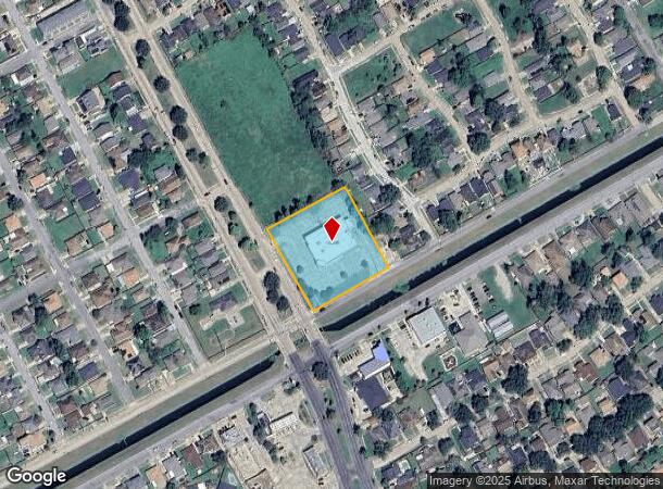
7401 Read Blvd, New Orleans, LA 70127
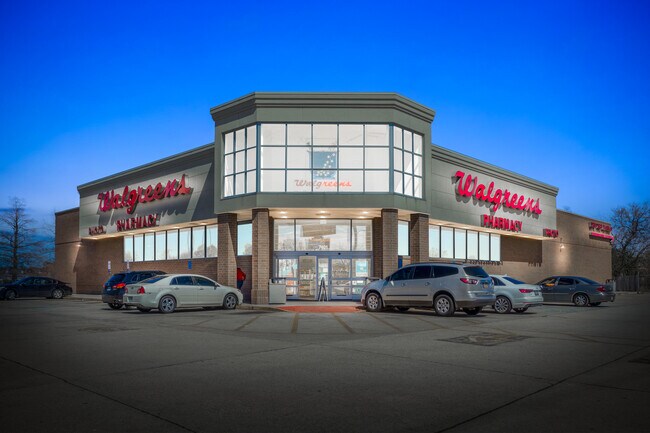
This Property Is For Sale
Current Lease Availabilities
NEARBY LISTINGS FOR SALE OR LEASE
Property Detail
7401 Read Blvd
New Orleans-Metairie, LA
S 7 Gr 4
3-9W-0-123-19
SQ SEC 7 GROVES 4 THRU 12 LO T WG-1 READ BD & MORRISON RD 288/289 X 276/268 PLAN 9-19-29 WALGREENS #4982 SEE E REC
Storebuilding
Orleans
AE
Louisiana
22087C0225D
wg-1
2025
1.79 AC
2025
New Orleans East
001737
New Orleans/Metairie/Kenner
14,544 SF
DEMOGRAPHICS near 7401 Read Blvd
1 Mile
3 Mile
5 Mile
2024 Total Population
14,750
58,134
79,968
2029 Population
14,092
55,286
76,029
Pop Growth 2024-2029
(4.46%)
(4.90%)
(4.93%)
Average Age
39
39
39
2024 Total Households
5,508
21,239
29,199
HH Growth 2024-2029
(5.01%)
(5.19%)
(5.17%)
Median Household Inc
$28,411
$34,924
$35,413
Avg Household Size
2.50
2.60
2.60
2024 Avg HH Vehicles
1.00
1.00
1.00
Median Home Value
$178,018
$180,269
$182,553
Median Year Built
1977
1976
1975
Nearby Places
- Restaurants
- Banks
- Shops
- Fitness
- Groceries
PUBLIC TRANSPORTATION
AIRPORT
Louis Armstrong New Orleans International
DRIVE
WALK
Distance
Louis Armstrong New Orleans International
29 min
21.0 mi
Freight Ports
Port of New Orleans
DRIVE
WALK
Distance
Port of New Orleans
23 min
13.4 mi
Nearby Properties
Address
Land Use
TOTAL SIZE
Lot Size
Zoning
Address
Land Use
TOTAL SIZE
Lot Size
Zoning
Address
Land Use
TOTAL SIZE
Lot Size
Zoning
21.35 AC
S-RS
Address
Land Use
TOTAL SIZE
Lot Size
Zoning
21.58 AC
C-3
Address
Land Use
TOTAL SIZE
Lot Size
Zoning
136,984 SF
11.29 AC
S-RD
Address
Land Use
TOTAL SIZE
Lot Size
Zoning
136,984 SF
4.67 AC
S-RS
Address
Land Use
TOTAL SIZE
Lot Size
Zoning
109,239 SF
5.77 AC
S-RS
Address
Land Use
TOTAL SIZE
Lot Size
Zoning
115,600 SF
16.96 AC
S-B2
Address
Land Use
TOTAL SIZE
Lot Size
Zoning
31,894 SF
500 AC
MI
Address
Land Use
TOTAL SIZE
Lot Size
Zoning
95,308 SF
16.36 AC
S-RS
Address
Land Use
TOTAL SIZE
Lot Size
Zoning
99,015 SF
6.99 AC
S-RS
Address
Land Use
TOTAL SIZE
Lot Size
Zoning
94,050 SF
4.96 AC
S-RS
Address
Land Use
TOTAL SIZE
Lot Size
Zoning
105,907 SF
3.84 AC
OS-N
Address
Land Use
TOTAL SIZE
Lot Size
Zoning
13,302 SF
53.89 AC
OS-R
Address
Land Use
TOTAL SIZE
Lot Size
Zoning
20.58 AC
S-RS
Address
Land Use
TOTAL SIZE
Lot Size
Zoning
179,095 SF
18.13 AC
C-3
Address
Land Use
TOTAL SIZE
Lot Size
Zoning
2.48 AC
S-RD
Address
Land Use
TOTAL SIZE
Lot Size
Zoning
205,380 SF
16.49 AC
MS
Address
Land Use
TOTAL SIZE
Lot Size
Zoning
13,563 SF
81.46 AC
OS-R
Address
Land Use
TOTAL SIZE
Lot Size
Zoning
33.59 AC
S-RS
Address
Land Use
TOTAL SIZE
Lot Size
Zoning
17.83 AC
OS-R
Address
Land Use
TOTAL SIZE
Lot Size
Zoning
93,584 SF
20.96 AC
S-RS
Address
Land Use
TOTAL SIZE
Lot Size
Zoning
20.48 AC
S-RS
Address
Land Use
TOTAL SIZE
Lot Size
Zoning
280,168 SF
11.47 AC
S-RM2
Address
Land Use
TOTAL SIZE
Lot Size
Zoning
5.92 AC
C-1
Address
Land Use
TOTAL SIZE
Lot Size
Zoning
83,918 SF
8.08 AC
S-RD
Address
Land Use
TOTAL SIZE
Lot Size
Zoning
147,600 SF
14.18 AC
C-3
Address
Land Use
TOTAL SIZE
Lot Size
Zoning
73,252 SF
5.37 AC
C-2
Address
Land Use
TOTAL SIZE
Lot Size
Zoning
506,319 SF
30.87 AC
S-RM2
Address
Land Use
TOTAL SIZE
Lot Size
Zoning
265,000 SF
11.93 AC
S-RM2
Address
Land Use
TOTAL SIZE
Lot Size
Zoning
202,568 SF
1 AC
The World's #1 Commercial Real Estate Marketplace
Connect with us
© 2025 CoStar Group
The information above has been obtained from sources believed reliable. While we do not doubt its accuracy we have not verified it and make no guarantee, warranty or representation about it. It is your responsibility to independently confirm its accuracy and completeness. Any projections, opinions, assumptions, or estimates used are for example only and do not represent the current or future performance of the property. The value of this transaction to you depends on tax and other factors which should be evaluated by your tax, financial, and legal advisors. You and your advisors should conduct a careful, independent investigation of the property to determine to your satisfaction the suitability of the property for your needs.