Property Record
7403 State Highway 45, Austin, TX 78739

Property Detail
7403 State Highway 45
Austin-Round Rock-San Marcos, TX
LOT 1 BLK A DAVAUS SUBD
931142
TRAVIS
Vacantlandnec
Texas
B and X Area of moderate flood hazard, usually the area between the limits of the 100-year and 500-year floods.
1
2025
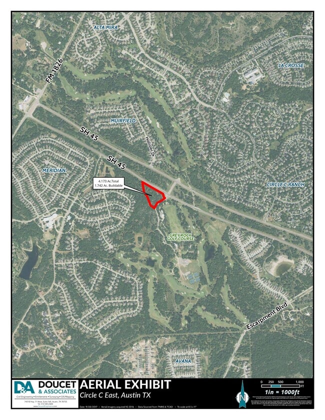
4.17 AC
2025
Southwest
033300
Austin
NEARBY LISTINGS FOR SALE OR LEASE
DEMOGRAPHICS near 7403 State Highway 45
1 mile
3 mile
5 mile
2025 Total Population
8,150
31,278
105,248
2030 Population
8,378
32,649
111,134
Pop Growth 2025-2030
+ 2.80%
+ 4.38%
+ 5.59%
Average Age
37
40
40
2025 Total Households
2,405
10,427
39,408
HH Growth 2025-2030
+ 3.49%
+ 5.27%
+ 6.16%
Median Household Inc
$237,280
$194,164
$143,438
Avg Household Size
3.30
3.00
2.60
2025 Avg HH Vehicles
2.00
2.00
2.00
Median Home Value
$806,235
$780,443
$708,570
Median Year Built
2008
2002
2000
Nearby Places
Map Layers
Map Styles
 Street
 Aerial
Layers
 Traffic
 Biking
Places
Listings with unknown addresses are not visible on the map
- Restaurants
- Banks
- Shops
- Fitness
- Groceries
PUBLIC TRANSPORTATION
AIRPORT
Austin-Bergstrom International
Drive
Walk
Distance
Austin-Bergstrom International
32 min
20.4 mi
Freight Ports
Calhoun Port
Drive
Walk
Distance
Calhoun Port
190 min
158.9 mi
SALE & LEASE HISTORY
LISTING DATE
SALE/LEASE

Sep 23, 2021
For Sale
Sep 08, 2022
For Sale
Nov 06, 2024
For Sale
Nearby Properties
Address
Land Use
TOTAL SIZE
Lot Size
Zoning
Address
Land Use
TOTAL SIZE
Lot Size
Zoning
240,640 SF
14.36 AC
Address
Land Use
TOTAL SIZE
Lot Size
Zoning
90,244 SF
23.03 AC
Address
Land Use
TOTAL SIZE
Lot Size
Zoning
119,556 SF
16.84 AC
Address
Land Use
TOTAL SIZE
Lot Size
Zoning
111,085 SF
14.17 AC
Address
Land Use
TOTAL SIZE
Lot Size
Zoning
102,256 SF
25.42 AC
Address
Land Use
TOTAL SIZE
Lot Size
Zoning
124,575 SF
11.99 AC
Address
Land Use
TOTAL SIZE
Lot Size
Zoning
144,732 SF
41.18 AC
Address
Land Use
TOTAL SIZE
Lot Size
Zoning
75,888 SF
25.97 AC
Address
Land Use
TOTAL SIZE
Lot Size
Zoning
107,798 SF
11.73 AC
Address
Land Use
TOTAL SIZE
Lot Size
Zoning
93,784 SF
15.57 AC
Address
Land Use
TOTAL SIZE
Lot Size
Zoning
42.18 AC
Address
Land Use
TOTAL SIZE
Lot Size
Zoning
81,376 SF
14.22 AC
Address
Land Use
TOTAL SIZE
Lot Size
Zoning
80,750 SF
22.76 AC
Address
Land Use
TOTAL SIZE
Lot Size
Zoning
58.49 AC
Address
Land Use
TOTAL SIZE
Lot Size
Zoning
19,843 SF
3.85 AC
Address
Land Use
TOTAL SIZE
Lot Size
Zoning
110,760 SF
11.75 AC
Address
Land Use
TOTAL SIZE
Lot Size
Zoning
367.20 AC
Address
Land Use
TOTAL SIZE
Lot Size
Zoning
20,641 SF
3.67 AC
Address
Land Use
TOTAL SIZE
Lot Size
Zoning
21,294 SF
10.26 AC
Address
Land Use
TOTAL SIZE
Lot Size
Zoning
39,704 SF
8.08 AC
Address
Land Use
TOTAL SIZE
Lot Size
Zoning
744 SF
23.78 AC
Address
Land Use
TOTAL SIZE
Lot Size
Zoning
37,248 SF
7.26 AC
Address
Land Use
TOTAL SIZE
Lot Size
Zoning
69.12 AC
Address
Land Use
TOTAL SIZE
Lot Size
Zoning
14,090 SF
3.08 AC
Address
Land Use
TOTAL SIZE
Lot Size
Zoning
13,768 SF
2.56 AC
Address
Land Use
TOTAL SIZE
Lot Size
Zoning
11,969 SF
3.85 AC
Address
Land Use
TOTAL SIZE
Lot Size
Zoning
2,298 SF
164.77 AC
Address
Land Use
TOTAL SIZE
Lot Size
Zoning
Address
Land Use
TOTAL SIZE
Lot Size
Zoning
135.66 AC
Address
Land Use
TOTAL SIZE
Lot Size
Zoning
15,825 SF
10.99 AC
The World's #1 Commercial Real Estate Marketplace
Connect with us
© 2026 CoStar Group
The information above has been obtained from sources believed reliable. While we do not doubt its accuracy we have not verified it and make no guarantee, warranty or representation about it. It is your responsibility to independently confirm its accuracy and completeness. Any projections, opinions, assumptions, or estimates used are for example only and do not represent the current or future performance of the property. The value of this transaction to you depends on tax and other factors which should be evaluated by your tax, financial, and legal advisors. You and your advisors should conduct a careful, independent investigation of the property to determine to your satisfaction the suitability of the property for your needs.