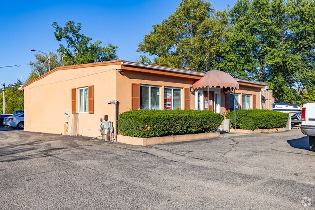
Property Record
7405 Forbes Rd, Cincinnati, OH 45233
NEARBY LISTINGS FOR SALE OR LEASE
-
-
View all Cincinnati listings for sale on LoopNet.com
Property Detail
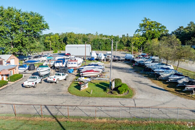
7405 Forbes Rd
167-0001-0083
FORBES RD 0.058 AC
Commercialacreage
Hamilton
AE
Ohio
21015C0040D
0.06 AC
2025
Forest Park/West
2025
Cincinnati/Dayton
010600
Cincinnati, OH-KY-IN
DEMOGRAPHICS near 7405 Forbes Rd
1 Mile
3 Mile
5 Mile
2024 Total Population
1,953
29,215
79,897
2029 Population
1,935
29,646
79,795
Pop Growth 2024-2029
(0.92%)
+ 1.48%
(0.13%)
Average Age
41
41
40
2024 Total Households
759
10,299
29,167
HH Growth 2024-2029
(1.32%)
+ 1.08%
(0.48%)
Median Household Inc
$79,700
$108,387
$91,804
Avg Household Size
2.50
2.80
2.70
2024 Avg HH Vehicles
2.00
2.00
2.00
Median Home Value
$209,934
$278,510
$220,396
Median Year Built
1960
1987
1975
Nearby Places
Map Layers
Map Styles
 Street
 Aerial
- Restaurants
- Banks
- Shops
- Fitness
- Groceries
PUBLIC TRANSPORTATION
AIRPORT
Cincinnati/Northern Kentucky International
DRIVE
WALK
Distance
Cincinnati/Northern Kentucky International
42 min
10.7 mi
Freight Ports
Port of Toledo
DRIVE
WALK
Distance
Port of Toledo
257 min
216.9 mi
SALE & LEASE HISTORY
LISTING DATE
SALE/LEASE

Jan 04, 2023
For Sale
Nearby Properties
Address
Land Use
TOTAL SIZE
Lot Size
Zoning
Address
Land Use
TOTAL SIZE
Lot Size
Zoning
127,712 SF
185 AC
Address
Land Use
TOTAL SIZE
Lot Size
Zoning
Address
Land Use
TOTAL SIZE
Lot Size
Zoning
Address
Land Use
TOTAL SIZE
Lot Size
Zoning
Address
Land Use
TOTAL SIZE
Lot Size
Zoning
Address
Land Use
TOTAL SIZE
Lot Size
Zoning
Address
Land Use
TOTAL SIZE
Lot Size
Zoning
520,320 SF
31.99 AC
Address
Land Use
TOTAL SIZE
Lot Size
Zoning
520,000 SF
26.09 AC
Address
Land Use
TOTAL SIZE
Lot Size
Zoning
713,360 SF
50.53 AC
Address
Land Use
TOTAL SIZE
Lot Size
Zoning
3.90 AC
RFC
Address
Land Use
TOTAL SIZE
Lot Size
Zoning
460,200 SF
28.39 AC
Address
Land Use
TOTAL SIZE
Lot Size
Zoning
25.80 AC
Address
Land Use
TOTAL SIZE
Lot Size
Zoning
Address
Land Use
TOTAL SIZE
Lot Size
Zoning
Address
Land Use
TOTAL SIZE
Lot Size
Zoning
15,672 SF
20.74 AC
Address
Land Use
TOTAL SIZE
Lot Size
Zoning
483,840 SF
26.87 AC
Address
Land Use
TOTAL SIZE
Lot Size
Zoning
25.15 AC
Address
Land Use
TOTAL SIZE
Lot Size
Zoning
415,784 SF
25.80 AC
Address
Land Use
TOTAL SIZE
Lot Size
Zoning
203,033 SF
15.62 AC
Address
Land Use
TOTAL SIZE
Lot Size
Zoning
300,000 SF
18.72 AC
Address
Land Use
TOTAL SIZE
Lot Size
Zoning
299,520 SF
19.36 AC
Address
Land Use
TOTAL SIZE
Lot Size
Zoning
211,200 SF
12.09 AC
Address
Land Use
TOTAL SIZE
Lot Size
Zoning
12.81 AC
Address
Land Use
TOTAL SIZE
Lot Size
Zoning
19.95 AC
Address
Land Use
TOTAL SIZE
Lot Size
Zoning
254,800 SF
22.49 AC
Address
Land Use
TOTAL SIZE
Lot Size
Zoning
1,272 SF
12.12 AC
Address
Land Use
TOTAL SIZE
Lot Size
Zoning
1,602 SF
342.06 AC
Address
Land Use
TOTAL SIZE
Lot Size
Zoning
195,132 SF
11.50 AC
Address
Land Use
TOTAL SIZE
Lot Size
Zoning
14.67 AC
Address
Land Use
TOTAL SIZE
Lot Size
Zoning
149,880 SF
10.45 AC
The World's #1 Commercial Real Estate Marketplace
Connect with us
© 2026 CoStar Group
The information above has been obtained from sources believed reliable. While we do not doubt its accuracy we have not verified it and make no guarantee, warranty or representation about it. It is your responsibility to independently confirm its accuracy and completeness. Any projections, opinions, assumptions, or estimates used are for example only and do not represent the current or future performance of the property. The value of this transaction to you depends on tax and other factors which should be evaluated by your tax, financial, and legal advisors. You and your advisors should conduct a careful, independent investigation of the property to determine to your satisfaction the suitability of the property for your needs.