Property Record
7408 82Nd St, Lubbock, TX 79424
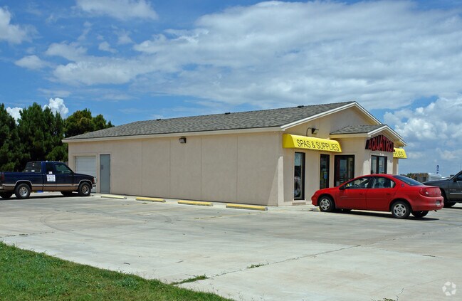


Property Detail
7408 82Nd St
Lubbock, TX
RANCHO VERDE ESTATES L 115A1
R103207
Lubbock
Storebuilding
Texas
B and X Area of moderate flood hazard, usually the area between the limits of the 100-year and 500-year floods.
115
2024
0.44 AC
2025
South Outer Lubbock
010412
Lubbock
2,090 SF
NEARBY LISTINGS FOR SALE OR LEASE
DEMOGRAPHICS near 7408 82Nd St
1 mile
3 mile
5 mile
2025 Total Population
3,968
44,329
118,416
2030 Population
4,201
46,705
124,585
Pop Growth 2025-2030
+ 5.87%
+ 5.36%
+ 5.21%
Average Age
35
37
37
2025 Total Households
1,348
17,113
48,668
HH Growth 2025-2030
+ 6.16%
+ 5.60%
+ 5.43%
Median Household Inc
$101,569
$90,229
$70,739
Avg Household Size
2.90
2.60
2.40
2025 Avg HH Vehicles
2.00
2.00
2.00
Median Home Value
$273,724
$267,649
$253,230
Median Year Built
2008
2005
1995
Nearby Places
Map Layers
Map Styles
 Street
 Aerial
Transit
 Traffic
 Biking
Places
Listings with unknown addresses are not visible on the map
- Restaurants
- Banks
- Shops
- Fitness
- Groceries
PUBLIC TRANSPORTATION
AIRPORT
Lubbock Preston Smith International
Drive
Walk
Distance
Lubbock Preston Smith International
34 min
20.0 mi
SALE & LEASE HISTORY
LISTING DATE
SALE/LEASE

Sep 09, 2020
For Lease
Nov 02, 2018
For Sale
Nov 02, 2016
For Lease
Mar 31, 2017
For Lease
Jul 09, 2020
For Lease
Nearby Properties
Address
Land Use
TOTAL SIZE
Lot Size
Zoning
Address
Land Use
TOTAL SIZE
Lot Size
Zoning
111,769 SF
25.03 AC
Address
Land Use
TOTAL SIZE
Lot Size
Zoning
236,871 SF
6.77 AC
Address
Land Use
TOTAL SIZE
Lot Size
Zoning
276,552 SF
12.05 AC
Address
Land Use
TOTAL SIZE
Lot Size
Zoning
290,322 SF
11.96 AC
Address
Land Use
TOTAL SIZE
Lot Size
Zoning
289,796 SF
14.67 AC
Address
Land Use
TOTAL SIZE
Lot Size
Zoning
187,409 SF
15.92 AC
Address
Land Use
TOTAL SIZE
Lot Size
Zoning
108,363 SF
11.35 AC
Address
Land Use
TOTAL SIZE
Lot Size
Zoning
215,338 SF
26.49 AC
Address
Land Use
TOTAL SIZE
Lot Size
Zoning
196,103 SF
12.33 AC
Address
Land Use
TOTAL SIZE
Lot Size
Zoning
149,710 SF
10.57 AC
Address
Land Use
TOTAL SIZE
Lot Size
Zoning
24,540 SF
8.06 AC
Address
Land Use
TOTAL SIZE
Lot Size
Zoning
69.21 AC
Address
Land Use
TOTAL SIZE
Lot Size
Zoning
103,560 SF
7.04 AC
Address
Land Use
TOTAL SIZE
Lot Size
Zoning
139,501 SF
10.56 AC
Address
Land Use
TOTAL SIZE
Lot Size
Zoning
128,355 SF
8.91 AC
Address
Land Use
TOTAL SIZE
Lot Size
Zoning
139,085 SF
17.53 AC
Address
Land Use
TOTAL SIZE
Lot Size
Zoning
75,080 SF
0.04 AC
Address
Land Use
TOTAL SIZE
Lot Size
Zoning
217,245 SF
61.96 AC
Address
Land Use
TOTAL SIZE
Lot Size
Zoning
55,778 SF
8.71 AC
Address
Land Use
TOTAL SIZE
Lot Size
Zoning
40,118 SF
3.82 AC
Address
Land Use
TOTAL SIZE
Lot Size
Zoning
81,695 SF
2.70 AC
Address
Land Use
TOTAL SIZE
Lot Size
Zoning
125,090 SF
12.03 AC
Address
Land Use
TOTAL SIZE
Lot Size
Zoning
99,432 SF
10.29 AC
Address
Land Use
TOTAL SIZE
Lot Size
Zoning
93,964 SF
9.37 AC
Address
Land Use
TOTAL SIZE
Lot Size
Zoning
101,400 SF
5.49 AC
Address
Land Use
TOTAL SIZE
Lot Size
Zoning
172,822 SF
11.78 AC
Address
Land Use
TOTAL SIZE
Lot Size
Zoning
26.73 AC
Address
Land Use
TOTAL SIZE
Lot Size
Zoning
29,212 SF
6.19 AC
Address
Land Use
TOTAL SIZE
Lot Size
Zoning
53,708 SF
2.17 AC
Address
Land Use
TOTAL SIZE
Lot Size
Zoning
39,864 SF
9.85 AC
The World's #1 Commercial Real Estate Marketplace
Connect with us
© 2026 CoStar Group
The information above has been obtained from sources believed reliable. While we do not doubt its accuracy we have not verified it and make no guarantee, warranty or representation about it. It is your responsibility to independently confirm its accuracy and completeness. Any projections, opinions, assumptions, or estimates used are for example only and do not represent the current or future performance of the property. The value of this transaction to you depends on tax and other factors which should be evaluated by your tax, financial, and legal advisors. You and your advisors should conduct a careful, independent investigation of the property to determine to your satisfaction the suitability of the property for your needs.