Property Record
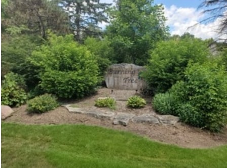
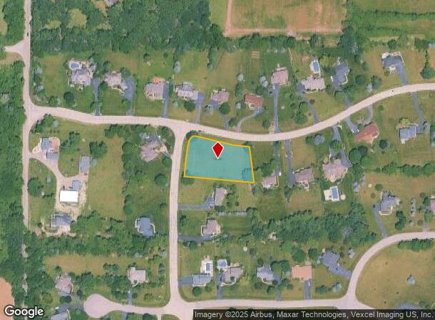
7409 Burning Tree Dr, Mchenry, IL 60050
NEARBY LISTINGS FOR SALE OR LEASE
Property Detail
7409 Burning Tree Dr
Chicago-Naperville-Elgin, IL-IN
Burning Tree Unit 1
09-31-203-001
DOC 95R034990 LT 17 BURNING TREE UNIT 1
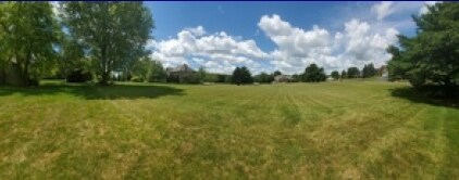
Vacantlandnec
McHenry
X
Illinois
17111C0205J
17
2024
0.93 AC
2024
Far Northwest
870501
Chicago
DEMOGRAPHICS near 7409 Burning Tree Dr
1 Mile
3 Mile
5 Mile
2024 Total Population
1,109
22,298
58,578
2029 Population
1,106
22,437
58,989
Pop Growth 2024-2029
(0.27%)
+ 0.62%
+ 0.70%
Average Age
40
41
41
2024 Total Households
360
8,372
22,524
HH Growth 2024-2029
0.00%
+ 0.63%
+ 0.68%
Median Household Inc
$135,416
$83,133
$83,084
Avg Household Size
3.00
2.60
2.50
2024 Avg HH Vehicles
3.00
2.00
2.00
Median Home Value
$349,069
$208,747
$225,154
Median Year Built
1997
1985
1986
Nearby Places
Map Layers
Map Styles
 Street
 Aerial
- Restaurants
- Banks
- Shops
- Fitness
- Groceries
PUBLIC TRANSPORTATION
COMMUTER RAIL
Mchenry Station (Union Pacific Northwest Line - Northeast Illinois Regional Commuter Railroad (Metra))
DRIVE
WALK
Distance
Mchenry Station (Union Pacific Northwest Line - Northeast Illinois Regional Commuter Railroad (Metra))
12 min
5.1 mi
Woodstock Station (Union Pacific Northwest Line - Northeast Illinois Regional Commuter Railroad (Metra))
DRIVE
WALK
Distance
Woodstock Station (Union Pacific Northwest Line - Northeast Illinois Regional Commuter Railroad (Metra))
15 min
8.0 mi
Freight Ports
Port Milwaukee
DRIVE
WALK
Distance
Port Milwaukee
95 min
69.2 mi
SALE & LEASE HISTORY
LISTING DATE
SALE/LEASE

Feb 26, 2021
For Sale
Nearby Properties
Address
Land Use
TOTAL SIZE
Lot Size
Zoning
Address
Land Use
TOTAL SIZE
Lot Size
Zoning
83,570 SF
3 AC
Address
Land Use
TOTAL SIZE
Lot Size
Zoning
3,840 SF
1 AC
Address
Land Use
TOTAL SIZE
Lot Size
Zoning
Address
Land Use
TOTAL SIZE
Lot Size
Zoning
Address
Land Use
TOTAL SIZE
Lot Size
Zoning
6,300 SF
5 AC
Address
Land Use
TOTAL SIZE
Lot Size
Zoning
2,800 SF
1.98 AC
Address
Land Use
TOTAL SIZE
Lot Size
Zoning
40,296 SF
1 AC
Address
Land Use
TOTAL SIZE
Lot Size
Zoning
105,003 SF
4 AC
Address
Land Use
TOTAL SIZE
Lot Size
Zoning
29,877 SF
6.83 AC
Address
Land Use
TOTAL SIZE
Lot Size
Zoning
7.81 AC
Address
Land Use
TOTAL SIZE
Lot Size
Zoning
1,012 SF
1.24 AC
Address
Land Use
TOTAL SIZE
Lot Size
Zoning
11,294 SF
2 AC
Address
Land Use
TOTAL SIZE
Lot Size
Zoning
1.93 AC
Address
Land Use
TOTAL SIZE
Lot Size
Zoning
4,160 SF
1.76 AC
Address
Land Use
TOTAL SIZE
Lot Size
Zoning
7,184 SF
0.83 AC
Address
Land Use
TOTAL SIZE
Lot Size
Zoning
10,625 SF
0.17 AC
Address
Land Use
TOTAL SIZE
Lot Size
Zoning
Address
Land Use
TOTAL SIZE
Lot Size
Zoning
5,564 SF
14.92 AC
Address
Land Use
TOTAL SIZE
Lot Size
Zoning
2.79 AC
Address
Land Use
TOTAL SIZE
Lot Size
Zoning
6,014 SF
4.94 AC
Address
Land Use
TOTAL SIZE
Lot Size
Zoning
18,060 SF
0.28 AC
Address
Land Use
TOTAL SIZE
Lot Size
Zoning
3,434 SF
0.75 AC
Address
Land Use
TOTAL SIZE
Lot Size
Zoning
3,970 SF
7.51 AC
Address
Land Use
TOTAL SIZE
Lot Size
Zoning
4,992 SF
3.16 AC
Address
Land Use
TOTAL SIZE
Lot Size
Zoning
5,000 SF
136.66 AC
Address
Land Use
TOTAL SIZE
Lot Size
Zoning
16,519 SF
1.72 AC
Address
Land Use
TOTAL SIZE
Lot Size
Zoning
2,960 SF
1 AC
Address
Land Use
TOTAL SIZE
Lot Size
Zoning
8.96 AC
Address
Land Use
TOTAL SIZE
Lot Size
Zoning
2,454 SF
0.63 AC
Address
Land Use
TOTAL SIZE
Lot Size
Zoning
9.90 AC
The World's #1 Commercial Real Estate Marketplace
Connect with us
© 2026 CoStar Group
The information above has been obtained from sources believed reliable. While we do not doubt its accuracy we have not verified it and make no guarantee, warranty or representation about it. It is your responsibility to independently confirm its accuracy and completeness. Any projections, opinions, assumptions, or estimates used are for example only and do not represent the current or future performance of the property. The value of this transaction to you depends on tax and other factors which should be evaluated by your tax, financial, and legal advisors. You and your advisors should conduct a careful, independent investigation of the property to determine to your satisfaction the suitability of the property for your needs.