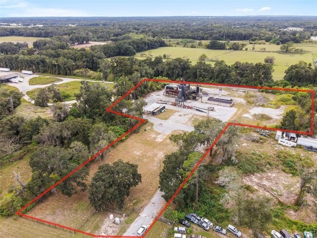
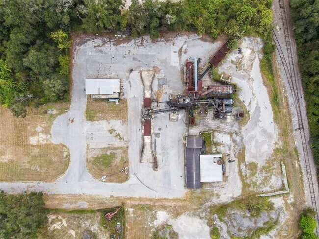
Property Record
7292 Nw Gainesville Rd, Ocala, FL 34475
NEARBY LISTINGS FOR SALE OR LEASE
Property Detail
7292 Nw Gainesville Rd
13242-000-00
SEC 23 TWP 14 RGE 21 S 115.85 FT OF NE 1/4 OF NW 1/4 W OF US HWY 441 & N 138.65 FT OF SE 1/4 OF NW 1/4 W OF US HWY 441 & BEGINNING AT A PT ON W BDY OF SE 1/4 OF NW 1/4 763.5 FT N FROM SW COR OF SE 1/4 OF NW 1/4 N 88-45 E 464.6 FT TO W ROW OF US HWY 4
Industrialacreage
Marion
AE
Florida
12083C0318E
6 AC
2024
Outlying Marion County
2024
Ocala
001500
Ocala, FL
DEMOGRAPHICS near 7292 Nw Gainesville Rd
1 Mile
3 Mile
5 Mile
2024 Total Population
305
11,158
35,864
2029 Population
347
12,583
40,286
Pop Growth 2024-2029
+ 13.77%
+ 12.77%
+ 12.33%
Average Age
40
41
43
2024 Total Households
128
3,973
13,343
HH Growth 2024-2029
+ 13.28%
+ 13.57%
+ 12.97%
Median Household Inc
$33,999
$49,742
$53,487
Avg Household Size
2.30
2.40
2.30
2024 Avg HH Vehicles
2.00
2.00
2.00
Median Home Value
$88,749
$170,912
$208,370
Median Year Built
1987
1993
1991
Nearby Places
Map Layers
Map Styles
 Street
 Aerial
- Restaurants
- Banks
- Shops
- Fitness
- Groceries
SALE & LEASE HISTORY
LISTING DATE
SALE/LEASE

Oct 14, 2022
For Sale
Nearby Properties
Address
Land Use
TOTAL SIZE
Lot Size
Zoning
Address
Land Use
TOTAL SIZE
Lot Size
Zoning
1,085,670 SF
89.70 AC
M1
Address
Land Use
TOTAL SIZE
Lot Size
Zoning
612,196 SF
50.06 AC
M1
Address
Land Use
TOTAL SIZE
Lot Size
Zoning
617,520 SF
46.08 AC
M2
Address
Land Use
TOTAL SIZE
Lot Size
Zoning
444,381 SF
60 AC
M1
Address
Land Use
TOTAL SIZE
Lot Size
Zoning
350,895 SF
27.85 AC
M1
Address
Land Use
TOTAL SIZE
Lot Size
Zoning
140,920 SF
28.09 AC
M2
Address
Land Use
TOTAL SIZE
Lot Size
Zoning
384,930 SF
17.76 AC
M1
Address
Land Use
TOTAL SIZE
Lot Size
Zoning
116,876 SF
23.78 AC
M2
Address
Land Use
TOTAL SIZE
Lot Size
Zoning
47,984 SF
448.37 AC
PUD
Address
Land Use
TOTAL SIZE
Lot Size
Zoning
44,100 SF
9.60 AC
R3
Address
Land Use
TOTAL SIZE
Lot Size
Zoning
89,640 SF
33.21 AC
B5
Address
Land Use
TOTAL SIZE
Lot Size
Zoning
72,855 SF
47.31 AC
B2
Address
Land Use
TOTAL SIZE
Lot Size
Zoning
47,900 SF
10.29 AC
B5
Address
Land Use
TOTAL SIZE
Lot Size
Zoning
10,894 SF
35.86 AC
B3
Address
Land Use
TOTAL SIZE
Lot Size
Zoning
49,915 SF
5 AC
PUD
Address
Land Use
TOTAL SIZE
Lot Size
Zoning
23,100 SF
4.18 AC
B2
Address
Land Use
TOTAL SIZE
Lot Size
Zoning
12,008 SF
30.03 AC
A1
Address
Land Use
TOTAL SIZE
Lot Size
Zoning
9,117 SF
18.84 AC
B3
Address
Land Use
TOTAL SIZE
Lot Size
Zoning
50,255 SF
689.76 AC
GU
Address
Land Use
TOTAL SIZE
Lot Size
Zoning
60,556 SF
11.73 AC
M1
Address
Land Use
TOTAL SIZE
Lot Size
Zoning
46,510 SF
3.64 AC
B4
Address
Land Use
TOTAL SIZE
Lot Size
Zoning
14,418 SF
8.39 AC
B5
Address
Land Use
TOTAL SIZE
Lot Size
Zoning
36,389 SF
25.84 AC
GU
Address
Land Use
TOTAL SIZE
Lot Size
Zoning
15,300 SF
7.11 AC
B5
Address
Land Use
TOTAL SIZE
Lot Size
Zoning
13,213 SF
4.60 AC
B2
Address
Land Use
TOTAL SIZE
Lot Size
Zoning
23,523 SF
9.90 AC
B3
Address
Land Use
TOTAL SIZE
Lot Size
Zoning
8.77 AC
M1
Address
Land Use
TOTAL SIZE
Lot Size
Zoning
37,400 SF
9.59 AC
B5
Address
Land Use
TOTAL SIZE
Lot Size
Zoning
37,812 SF
10.23 AC
M2
Address
Land Use
TOTAL SIZE
Lot Size
Zoning
10,038 SF
10.64 AC
B4
The World's #1 Commercial Real Estate Marketplace
Connect with us
© 2025 CoStar Group
The information above has been obtained from sources believed reliable. While we do not doubt its accuracy we have not verified it and make no guarantee, warranty or representation about it. It is your responsibility to independently confirm its accuracy and completeness. Any projections, opinions, assumptions, or estimates used are for example only and do not represent the current or future performance of the property. The value of this transaction to you depends on tax and other factors which should be evaluated by your tax, financial, and legal advisors. You and your advisors should conduct a careful, independent investigation of the property to determine to your satisfaction the suitability of the property for your needs.