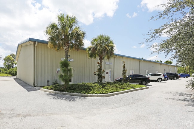
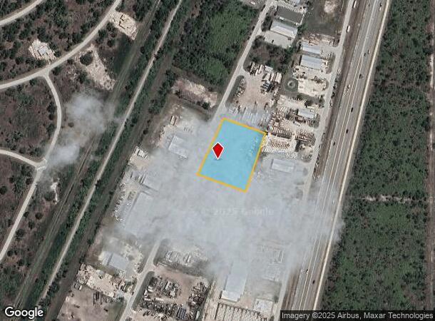
Property Record
7410 Sawyer Cir, Port Charlotte, FL 33981

Current Lease Availabilities
NEARBY LISTINGS FOR SALE OR LEASE
Property Detail
7410 Sawyer Cir
Punta Gorda, FL
Pch 095 5358 0032 Port Charlotte
412108277005
PCH 095 5358 0032 PORT CHARLOTTE SEC95 3RD REP BLK5358 LT 32 1069-331 2259/1289 2658/368 2849/671 3773/1227 3831/1225 PCH 095 5358 0033 PORT CHARLOTTE SEC95 3RD REP BLK5358 LT 33 1069-331 2259/1289 2658/368 2849/671 3773/1227 3831/1225 PCH 0
Warehouse
Charlotte
AE
Florida
12015C0211G
32
2024
1.62 AC
2025
Charlotte County
030102
Southwest Florida
15,000 SF
DEMOGRAPHICS near 7410 Sawyer Cir
1 Mile
3 Mile
5 Mile
2024 Total Population
2,295
20,466
44,036
2029 Population
2,823
24,945
53,534
Pop Growth 2024-2029
+ 23.01%
+ 21.89%
+ 21.57%
Average Age
53
54
56
2024 Total Households
1,050
9,312
20,567
HH Growth 2024-2029
+ 23.05%
+ 22.06%
+ 21.75%
Median Household Inc
$60,783
$64,386
$62,741
Avg Household Size
2.20
2.20
2.10
2024 Avg HH Vehicles
2.00
2.00
2.00
Median Home Value
$277,008
$292,119
$285,561
Median Year Built
1994
1999
1998
Nearby Places
Map Layers
Map Styles
 Street
 Aerial
- Restaurants
- Banks
- Shops
- Fitness
- Groceries
PUBLIC TRANSPORTATION
AIRPORT
Punta Gorda
DRIVE
WALK
Distance
Punta Gorda
37 min
21.3 mi
Freight Ports
Port Manatee
DRIVE
WALK
Distance
Port Manatee
87 min
63.2 mi
Nearby Properties
Address
Land Use
TOTAL SIZE
Lot Size
Zoning
Address
Land Use
TOTAL SIZE
Lot Size
Zoning
99,840 SF
7.60 AC
IG
Address
Land Use
TOTAL SIZE
Lot Size
Zoning
67,466 SF
16.30 AC
CG
Address
Land Use
TOTAL SIZE
Lot Size
Zoning
27.65 AC
RMF15
Address
Land Use
TOTAL SIZE
Lot Size
Zoning
108,048 SF
14.84 AC
CG
Address
Land Use
TOTAL SIZE
Lot Size
Zoning
132.79 AC
PKR
Address
Land Use
TOTAL SIZE
Lot Size
Zoning
2,016 SF
315.56 AC
PD
Address
Land Use
TOTAL SIZE
Lot Size
Zoning
51,683 SF
7.16 AC
CG
Address
Land Use
TOTAL SIZE
Lot Size
Zoning
100,910 SF
22.85 AC
RSF3.5
Address
Land Use
TOTAL SIZE
Lot Size
Zoning
34.11 AC
CG
Address
Land Use
TOTAL SIZE
Lot Size
Zoning
20.12 AC
CG
Address
Land Use
TOTAL SIZE
Lot Size
Zoning
38.14 AC
IG
Address
Land Use
TOTAL SIZE
Lot Size
Zoning
6,055 SF
2.74 AC
RMF15
Address
Land Use
TOTAL SIZE
Lot Size
Zoning
12,300 SF
5.02 AC
IG
Address
Land Use
TOTAL SIZE
Lot Size
Zoning
0.20 AC
RSF3.5
Address
Land Use
TOTAL SIZE
Lot Size
Zoning
6,476 SF
17.26 AC
II
Address
Land Use
TOTAL SIZE
Lot Size
Zoning
4,776 SF
20 AC
II
Address
Land Use
TOTAL SIZE
Lot Size
Zoning
560 SF
10.23 AC
IG
Address
Land Use
TOTAL SIZE
Lot Size
Zoning
16.53 AC
CG
Address
Land Use
TOTAL SIZE
Lot Size
Zoning
8,510 SF
2.25 AC
CG
Address
Land Use
TOTAL SIZE
Lot Size
Zoning
5,222 SF
85.60 AC
RMF10
Address
Land Use
TOTAL SIZE
Lot Size
Zoning
3,864 SF
2 AC
CG
Address
Land Use
TOTAL SIZE
Lot Size
Zoning
12,907 SF
165.69 AC
RSF5
Address
Land Use
TOTAL SIZE
Lot Size
Zoning
18,599 SF
1.96 AC
IG
Address
Land Use
TOTAL SIZE
Lot Size
Zoning
576 SF
5 AC
II
Address
Land Use
TOTAL SIZE
Lot Size
Zoning
10.88 AC
CG
Address
Land Use
TOTAL SIZE
Lot Size
Zoning
11,708 SF
9.99 AC
II
Address
Land Use
TOTAL SIZE
Lot Size
Zoning
3,767 SF
88.50 AC
RSF2
Address
Land Use
TOTAL SIZE
Lot Size
Zoning
4,000 SF
7.78 AC
RMF10
Address
Land Use
TOTAL SIZE
Lot Size
Zoning
3,589 SF
1.47 AC
CG
The World's #1 Commercial Real Estate Marketplace
Connect with us
© 2026 CoStar Group
The information above has been obtained from sources believed reliable. While we do not doubt its accuracy we have not verified it and make no guarantee, warranty or representation about it. It is your responsibility to independently confirm its accuracy and completeness. Any projections, opinions, assumptions, or estimates used are for example only and do not represent the current or future performance of the property. The value of this transaction to you depends on tax and other factors which should be evaluated by your tax, financial, and legal advisors. You and your advisors should conduct a careful, independent investigation of the property to determine to your satisfaction the suitability of the property for your needs.