Property Record
7410 W 101St Ave, Crown Point, IN 46307

NEARBY LISTINGS FOR SALE OR LEASE
-
-
View all Crown Point listings for sale on LoopNet.com
Property Detail
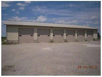
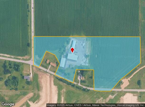
7410 W 101St Ave
Chicago-Naperville-Elgin, IL-IN-WI
PT. SE. SW. LYING N. OF CENTER LINE OF 101ST AVE 13.934AC
45-11-35-377-003.000-032
Lake
Farms
Indiana
X
1
18089C0241E
13.93 AC
2023
Indiana
2024
Chicago
042611
DEMOGRAPHICS near 7410 W 101St Ave
1 Mile
3 Mile
5 Mile
2024 Total Population
2,259
31,610
110,157
2029 Population
2,338
31,813
110,470
Pop Growth 2024-2029
+ 3.50%
+ 0.64%
+ 0.28%
Average Age
41
42
42
2024 Total Households
831
11,646
42,728
HH Growth 2024-2029
+ 3.61%
+ 0.58%
+ 0.26%
Median Household Inc
$103,854
$94,745
$85,690
Avg Household Size
2.70
2.60
2.50
2024 Avg HH Vehicles
2.00
2.00
2.00
Median Home Value
$314,431
$288,762
$266,443
Median Year Built
2006
1993
1990
Nearby Places
Map Layers
Map Styles
 Street
 Aerial
- Restaurants
- Banks
- Shops
- Fitness
- Groceries
PUBLIC TRANSPORTATION
COMMUTER RAIL
Dyer Amtrak (Cardinal - Amtrak)
DRIVE
WALK
Distance
Dyer Amtrak (Cardinal - Amtrak)
20 min
9.7 mi
AIRPORT
Chicago Midway International
DRIVE
WALK
Distance
Chicago Midway International
63 min
37.9 mi
Freight Ports
Port Milwaukee
DRIVE
WALK
Distance
Port Milwaukee
166 min
124.2 mi
Nearby Properties
Address
Land Use
TOTAL SIZE
Lot Size
Zoning
Address
Land Use
TOTAL SIZE
Lot Size
Zoning
218,510 SF
14.96 AC
Address
Land Use
TOTAL SIZE
Lot Size
Zoning
116,352 SF
9 AC
Address
Land Use
TOTAL SIZE
Lot Size
Zoning
116,352 SF
8.08 AC
Address
Land Use
TOTAL SIZE
Lot Size
Zoning
304,429 SF
84.07 AC
Address
Land Use
TOTAL SIZE
Lot Size
Zoning
88,167 SF
22.54 AC
Address
Land Use
TOTAL SIZE
Lot Size
Zoning
87,264 SF
7.74 AC
Address
Land Use
TOTAL SIZE
Lot Size
Zoning
67,446 SF
10.02 AC
R33
Address
Land Use
TOTAL SIZE
Lot Size
Zoning
53,445 SF
15.17 AC
R3
Address
Land Use
TOTAL SIZE
Lot Size
Zoning
152,472 SF
16.15 AC
Address
Land Use
TOTAL SIZE
Lot Size
Zoning
124,474 SF
12.29 AC
R33
Address
Land Use
TOTAL SIZE
Lot Size
Zoning
52,896 SF
4.06 AC
R33
Address
Land Use
TOTAL SIZE
Lot Size
Zoning
68,634 SF
6.84 AC
R33
Address
Land Use
TOTAL SIZE
Lot Size
Zoning
122,908 SF
9.58 AC
Address
Land Use
TOTAL SIZE
Lot Size
Zoning
26,738 SF
4.67 AC
Address
Land Use
TOTAL SIZE
Lot Size
Zoning
42,090 SF
4.04 AC
Address
Land Use
TOTAL SIZE
Lot Size
Zoning
33,683 SF
15.70 AC
R3
Address
Land Use
TOTAL SIZE
Lot Size
Zoning
12,962 SF
14.12 AC
Address
Land Use
TOTAL SIZE
Lot Size
Zoning
18,000 SF
2.60 AC
R3
Address
Land Use
TOTAL SIZE
Lot Size
Zoning
18.17 AC
Address
Land Use
TOTAL SIZE
Lot Size
Zoning
83,401 SF
10.28 AC
Address
Land Use
TOTAL SIZE
Lot Size
Zoning
19,194 SF
3.29 AC
R33
Address
Land Use
TOTAL SIZE
Lot Size
Zoning
19,992 SF
6.71 AC
R33
Address
Land Use
TOTAL SIZE
Lot Size
Zoning
20,270 SF
2.41 AC
Address
Land Use
TOTAL SIZE
Lot Size
Zoning
55,951 SF
5.50 AC
Address
Land Use
TOTAL SIZE
Lot Size
Zoning
11,368 SF
2.82 AC
Address
Land Use
TOTAL SIZE
Lot Size
Zoning
9,696 SF
1.54 AC
Address
Land Use
TOTAL SIZE
Lot Size
Zoning
8.36 AC
Address
Land Use
TOTAL SIZE
Lot Size
Zoning
28,416 SF
6.06 AC
Address
Land Use
TOTAL SIZE
Lot Size
Zoning
17 AC
Address
Land Use
TOTAL SIZE
Lot Size
Zoning
24,360 SF
3.83 AC
The World's #1 Commercial Real Estate Marketplace
Connect with us
© 2025 CoStar Group
The information above has been obtained from sources believed reliable. While we do not doubt its accuracy we have not verified it and make no guarantee, warranty or representation about it. It is your responsibility to independently confirm its accuracy and completeness. Any projections, opinions, assumptions, or estimates used are for example only and do not represent the current or future performance of the property. The value of this transaction to you depends on tax and other factors which should be evaluated by your tax, financial, and legal advisors. You and your advisors should conduct a careful, independent investigation of the property to determine to your satisfaction the suitability of the property for your needs.