Property Record
74130 Fulton St, Armada, MI 48005
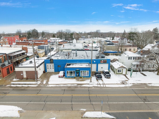
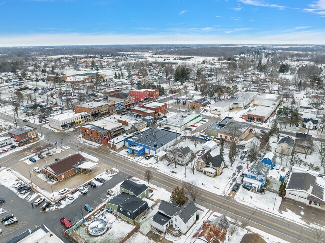
This Property Is For Sale
NEARBY LISTINGS FOR SALE OR LEASE
-
-
View all Armada listings for sale on LoopNet.com
Property Detail
74130 Fulton St
Detroit-Warren-Dearborn, MI
Village
25-02-24-155-018
02-24-155-018 VILLAGE OF ARMADA ASSESSORS PLAT NO 4 W 35 FT OF LOT 75 & LOT 76 EXC S 1.08 FT OF W 38 FT
Lightindustrial
Macomb
X
Michigan
26099C0134G
75-76
2025
0.27 AC
2025
St Clair & Lapeer Counties
212000
Detroit
9,213 SF
DEMOGRAPHICS near 74130 Fulton St
1 mile
3 mile
5 mile
2024 Total Population
1,765
3,711
8,110
2029 Population
1,712
3,605
7,896
Pop Growth 2024-2029
(3.00%)
(2.86%)
(2.64%)
Average Age
43
43
43
2024 Total Households
643
1,357
2,979
HH Growth 2024-2029
(3.27%)
(3.02%)
(2.75%)
Median Household Inc
$98,437
$93,627
$90,647
Avg Household Size
2.60
2.60
2.60
2024 Avg HH Vehicles
2.00
3.00
3.00
Median Home Value
$237,766
$272,841
$291,412
Median Year Built
1957
1973
1974
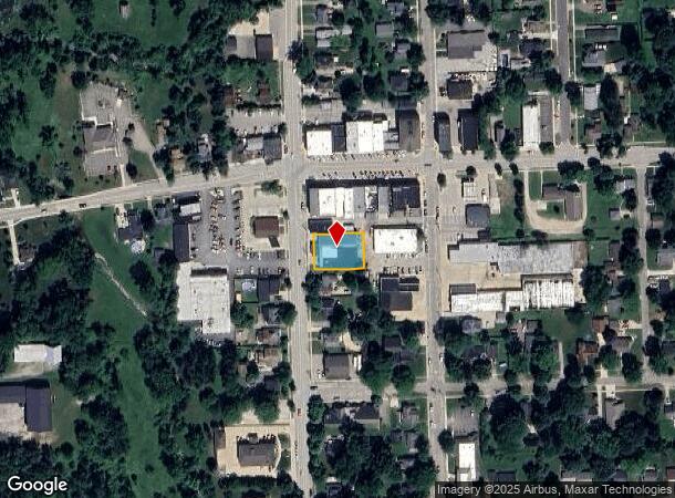
Nearby Places
Map Layers
Map Styles
 Street
 Aerial
Transit
 Traffic
 Biking
Places
Listings with unknown addresses are not visible on the map
- Restaurants
- Banks
- Shops
- Fitness
- Groceries
Nearby Properties
Address
Land Use
TOTAL SIZE
Lot Size
Zoning
Address
Land Use
TOTAL SIZE
Lot Size
Zoning
3,064 SF
552.76 AC
RI
Address
Land Use
TOTAL SIZE
Lot Size
Zoning
37,388 SF
6.06 AC
V-R1
Address
Land Use
TOTAL SIZE
Lot Size
Zoning
29,945 SF
5.42 AC
V-R1
Address
Land Use
TOTAL SIZE
Lot Size
Zoning
6,965 SF
276.65 AC
AG 1.75
Address
Land Use
TOTAL SIZE
Lot Size
Zoning
34,894 SF
2.32 AC
V-RM
Address
Land Use
TOTAL SIZE
Lot Size
Zoning
1,932 SF
108 AC
AG 1.75
Address
Land Use
TOTAL SIZE
Lot Size
Zoning
2,820 SF
133.10 AC
RI
Address
Land Use
TOTAL SIZE
Lot Size
Zoning
39,535 SF
6.77 AC
M-1
Address
Land Use
TOTAL SIZE
Lot Size
Zoning
7,978 SF
13.25 AC
RI
Address
Land Use
TOTAL SIZE
Lot Size
Zoning
5,242 SF
20.85 AC
Address
Land Use
TOTAL SIZE
Lot Size
Zoning
5,538 SF
3.74 AC
RI
Address
Land Use
TOTAL SIZE
Lot Size
Zoning
4,348 SF
16.36 AC
RI
Address
Land Use
TOTAL SIZE
Lot Size
Zoning
2,513 SF
18.70 AC
AG 1.75
Address
Land Use
TOTAL SIZE
Lot Size
Zoning
4,890 SF
1.96 AC
B-2
Address
Land Use
TOTAL SIZE
Lot Size
Zoning
7,040 SF
26.33 AC
RI
Address
Land Use
TOTAL SIZE
Lot Size
Zoning
20,247 SF
1.49 AC
V-C2
Address
Land Use
TOTAL SIZE
Lot Size
Zoning
4,119 SF
9.88 AC
Address
Land Use
TOTAL SIZE
Lot Size
Zoning
3,404 SF
9.60 AC
RI
Address
Land Use
TOTAL SIZE
Lot Size
Zoning
3,000 SF
10.69 AC
RI
Address
Land Use
TOTAL SIZE
Lot Size
Zoning
8,064 SF
1.03 AC
BI
Address
Land Use
TOTAL SIZE
Lot Size
Zoning
3,157 SF
8.43 AC
RI
Address
Land Use
TOTAL SIZE
Lot Size
Zoning
3,203 SF
AG 1.75
Address
Land Use
TOTAL SIZE
Lot Size
Zoning
4,705 SF
10.62 AC
Address
Land Use
TOTAL SIZE
Lot Size
Zoning
27.01 AC
RM
Address
Land Use
TOTAL SIZE
Lot Size
Zoning
4,259 SF
2.09 AC
Address
Land Use
TOTAL SIZE
Lot Size
Zoning
3,932 SF
2.27 AC
Address
Land Use
TOTAL SIZE
Lot Size
Zoning
2,012 SF
12.38 AC
R-1
Address
Land Use
TOTAL SIZE
Lot Size
Zoning
3,082 SF
5 AC
RI
Address
Land Use
TOTAL SIZE
Lot Size
Zoning
1,404 SF
181.35 AC
AG 1.75
Address
Land Use
TOTAL SIZE
Lot Size
Zoning
2,840 SF
159 AC
AGIMPROVE
The World's #1 Commercial Real Estate Marketplace
Connect with us
© 2026 CoStar Group
The information above has been obtained from sources believed reliable. While we do not doubt its accuracy we have not verified it and make no guarantee, warranty or representation about it. It is your responsibility to independently confirm its accuracy and completeness. Any projections, opinions, assumptions, or estimates used are for example only and do not represent the current or future performance of the property. The value of this transaction to you depends on tax and other factors which should be evaluated by your tax, financial, and legal advisors. You and your advisors should conduct a careful, independent investigation of the property to determine to your satisfaction the suitability of the property for your needs.