Property Record
7415 Commonwealth Ave, Jacksonville, FL 32099
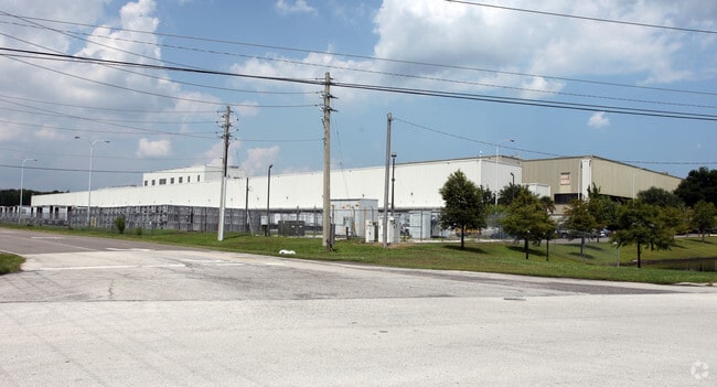

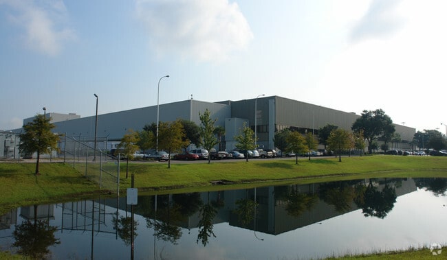
Property Detail
7415 Commonwealth Ave
004889-0905
11-2S-25E 48.016 PT GOVT LOTS 7,10,11, PT SEC 41 RECD O/R 3341-541 BEING TRACT 100(EX PT RECD O/RS 5321-124,7485-737)
Federalproperty
DUVAL
PBF-2
Florida
B and X Area of moderate flood hazard, usually the area between the limits of the 100-year and 500-year floods.
7,10,
0
46.91 AC
2026
West Side
011901
Jacksonville (Florida)
874,178 SF
Jacksonville, FL
NEARBY LISTINGS FOR SALE OR LEASE
DEMOGRAPHICS near 7415 Commonwealth Ave
1 mile
3 mile
5 mile
2025 Total Population
951
23,427
129,019
2030 Population
1,033
25,142
137,576
Pop Growth 2025-2030
+ 8.62%
+ 7.32%
+ 6.63%
Average Age
40
40
39
2025 Total Households
360
9,060
51,410
HH Growth 2025-2030
+ 8.89%
+ 7.58%
+ 6.89%
Median Household Inc
$48,181
$54,318
$55,533
Avg Household Size
2.50
2.50
2.40
2025 Avg HH Vehicles
2.00
2.00
2.00
Median Home Value
$291,249
$211,878
$233,210
Median Year Built
1993
1976
1969
Nearby Places
Map Layers
Map Styles
 Street
 Aerial
Layers
 Traffic
 Biking
Places
Listings with unknown addresses are not visible on the map
- Restaurants
- Banks
- Shops
- Fitness
- Groceries
PUBLIC TRANSPORTATION
COMMUTER RAIL
Jacksonville (Silver Meteor - Amtrak, Silver Star - Amtrak)
Drive
Walk
Distance
Jacksonville (Silver Meteor - Amtrak, Silver Star - Amtrak)
11 min
5.7 mi
AIRPORT
Jacksonville International
Drive
Walk
Distance
Jacksonville International
25 min
16.2 mi
Freight Ports
Jacksonville Port
Drive
Walk
Distance
Jacksonville Port
22 min
13.6 mi
Nearby Properties
Address
Land Use
TOTAL SIZE
Lot Size
Zoning
Address
Land Use
TOTAL SIZE
Lot Size
Zoning
973,797 SF
105.79 AC
PUD
Address
Land Use
TOTAL SIZE
Lot Size
Zoning
600,857 SF
38.14 AC
IL
Address
Land Use
TOTAL SIZE
Lot Size
Zoning
506,816 SF
39.32 AC
IBP
Address
Land Use
TOTAL SIZE
Lot Size
Zoning
465,664 SF
21.27 AC
IL
Address
Land Use
TOTAL SIZE
Lot Size
Zoning
888,083 SF
46.65 AC
IL
Address
Land Use
TOTAL SIZE
Lot Size
Zoning
352,439 SF
3.40 AC
CCBD
Address
Land Use
TOTAL SIZE
Lot Size
Zoning
397,865 SF
42 AC
IL
Address
Land Use
TOTAL SIZE
Lot Size
Zoning
222,138 SF
13.18 AC
IL
Address
Land Use
TOTAL SIZE
Lot Size
Zoning
449,367 SF
26.16 AC
PUD
Address
Land Use
TOTAL SIZE
Lot Size
Zoning
414,674 SF
21.03 AC
PUD
Address
Land Use
TOTAL SIZE
Lot Size
Zoning
505,748 SF
94.71 AC
IL
Address
Land Use
TOTAL SIZE
Lot Size
Zoning
594,573 SF
27.69 AC
IL
Address
Land Use
TOTAL SIZE
Lot Size
Zoning
392,050 SF
50.22 AC
PUD
Address
Land Use
TOTAL SIZE
Lot Size
Zoning
307,732 SF
41.23 AC
IL
Address
Land Use
TOTAL SIZE
Lot Size
Zoning
299,588 SF
75.26 AC
IBP
Address
Land Use
TOTAL SIZE
Lot Size
Zoning
311,382 SF
18.57 AC
PUD
Address
Land Use
TOTAL SIZE
Lot Size
Zoning
233,363 SF
20.36 AC
PUD
Address
Land Use
TOTAL SIZE
Lot Size
Zoning
255,048 SF
20.15 AC
IL
Address
Land Use
TOTAL SIZE
Lot Size
Zoning
262,792 SF
15.23 AC
PUD
Address
Land Use
TOTAL SIZE
Lot Size
Zoning
249,082 SF
31.28 AC
PUD
Address
Land Use
TOTAL SIZE
Lot Size
Zoning
240,050 SF
28.53 AC
IBP
Address
Land Use
TOTAL SIZE
Lot Size
Zoning
189,832 SF
13.08 AC
PUD
Address
Land Use
TOTAL SIZE
Lot Size
Zoning
171,572 SF
10.47 AC
PUD
Address
Land Use
TOTAL SIZE
Lot Size
Zoning
216,022 SF
15.36 AC
PUD
Address
Land Use
TOTAL SIZE
Lot Size
Zoning
296,575 SF
16.24 AC
PUD
Address
Land Use
TOTAL SIZE
Lot Size
Zoning
274,925 SF
19.70 AC
PUD
Address
Land Use
TOTAL SIZE
Lot Size
Zoning
323,261 SF
56.62 AC
IL
Address
Land Use
TOTAL SIZE
Lot Size
Zoning
236,224 SF
14.13 AC
PUD
Address
Land Use
TOTAL SIZE
Lot Size
Zoning
162,283 SF
14.29 AC
IL
The World's #1 Commercial Real Estate Marketplace
Connect with us
© 2026 CoStar Group
The information above has been obtained from sources believed reliable. While we do not doubt its accuracy we have not verified it and make no guarantee, warranty or representation about it. It is your responsibility to independently confirm its accuracy and completeness. Any projections, opinions, assumptions, or estimates used are for example only and do not represent the current or future performance of the property. The value of this transaction to you depends on tax and other factors which should be evaluated by your tax, financial, and legal advisors. You and your advisors should conduct a careful, independent investigation of the property to determine to your satisfaction the suitability of the property for your needs.