Property Record
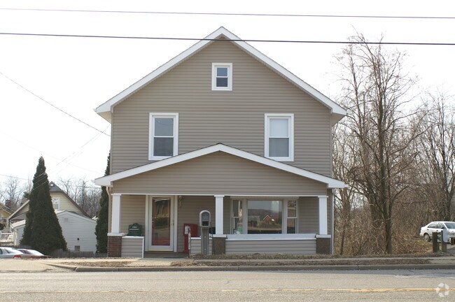
742 Main St, Steubenville, OH 43953


Property Detail
742 Main St
06-00763-000
23 LONGVIEW 52.6 X136 IRR MAP 06-4-61
Commercialnec
Jefferson
B and X Area of moderate flood hazard, usually the area between the limits of the 100-year and 500-year floods.
Ohio
2025
0.19 AC
2025
Ohio North Area
001200
Other Market Areas
728 SF
Weirton-Steubenville, WV-OH
NEARBY LISTINGS FOR SALE OR LEASE
DEMOGRAPHICS near 742 Main St
1 mile
3 mile
5 mile
2025 Total Population
3,700
14,707
32,382
2030 Population
3,565
14,187
31,697
Pop Growth 2025-2030
(3.65%)
(3.54%)
(2.12%)
Average Age
45
45
42
2025 Total Households
1,655
6,358
13,188
HH Growth 2025-2030
(3.75%)
(3.71%)
(2.36%)
Median Household Inc
$69,860
$70,028
$56,968
Avg Household Size
2.20
2.20
2.20
2025 Avg HH Vehicles
2.00
2.00
2.00
Median Home Value
$153,470
$155,827
$145,598
Median Year Built
1969
1964
1959
Nearby Places
Map Layers
Map Styles
 Street
 Aerial
Layers
 Traffic
 Biking
Places
Listings with unknown addresses are not visible on the map
- Restaurants
- Banks
- Shops
- Fitness
- Groceries
PUBLIC TRANSPORTATION
AIRPORT
Pittsburgh International
Drive
Walk
Distance
Pittsburgh International
55 min
34.9 mi
Freight Ports
Port of Toledo
Drive
Walk
Distance
Port of Toledo
268 min
213.6 mi
SALE & LEASE HISTORY
LISTING DATE
SALE/LEASE

Oct 08, 2020
For Sale
Nearby Properties
Address
Land Use
TOTAL SIZE
Lot Size
Zoning
Address
Land Use
TOTAL SIZE
Lot Size
Zoning
23.40 AC
Address
Land Use
TOTAL SIZE
Lot Size
Zoning
6,674 SF
74.94 AC
Address
Land Use
TOTAL SIZE
Lot Size
Zoning
207,741 SF
14.08 AC
Address
Land Use
TOTAL SIZE
Lot Size
Zoning
321,963 SF
35.09 AC
Address
Land Use
TOTAL SIZE
Lot Size
Zoning
3,600 SF
29 AC
Address
Land Use
TOTAL SIZE
Lot Size
Zoning
13,948 SF
1.57 AC
Address
Land Use
TOTAL SIZE
Lot Size
Zoning
1,040 SF
580.81 AC
Address
Land Use
TOTAL SIZE
Lot Size
Zoning
49,486 SF
9.61 AC
Address
Land Use
TOTAL SIZE
Lot Size
Zoning
134,390 SF
54.80 AC
Address
Land Use
TOTAL SIZE
Lot Size
Zoning
6,300 SF
108.70 AC
Address
Land Use
TOTAL SIZE
Lot Size
Zoning
10,488 SF
3.17 AC
Address
Land Use
TOTAL SIZE
Lot Size
Zoning
37,028 SF
13.92 AC
Address
Land Use
TOTAL SIZE
Lot Size
Zoning
125,738 SF
14.59 AC
Address
Land Use
TOTAL SIZE
Lot Size
Zoning
6,058 SF
16.04 AC
Address
Land Use
TOTAL SIZE
Lot Size
Zoning
26,200 SF
4.48 AC
Address
Land Use
TOTAL SIZE
Lot Size
Zoning
35,311 SF
3.87 AC
Address
Land Use
TOTAL SIZE
Lot Size
Zoning
47,424 SF
9.30 AC
Address
Land Use
TOTAL SIZE
Lot Size
Zoning
11,536 SF
3.60 AC
Address
Land Use
TOTAL SIZE
Lot Size
Zoning
103,360 SF
9.40 AC
Address
Land Use
TOTAL SIZE
Lot Size
Zoning
64,139 SF
10.65 AC
Address
Land Use
TOTAL SIZE
Lot Size
Zoning
2.07 AC
Address
Land Use
TOTAL SIZE
Lot Size
Zoning
7,175 SF
6.08 AC
Address
Land Use
TOTAL SIZE
Lot Size
Zoning
30,000 SF
4.34 AC
Address
Land Use
TOTAL SIZE
Lot Size
Zoning
Address
Land Use
TOTAL SIZE
Lot Size
Zoning
9,114 SF
4.46 AC
Address
Land Use
TOTAL SIZE
Lot Size
Zoning
3,816 SF
2.07 AC
Address
Land Use
TOTAL SIZE
Lot Size
Zoning
11.27 AC
Address
Land Use
TOTAL SIZE
Lot Size
Zoning
1,452 SF
8.51 AC
Address
Land Use
TOTAL SIZE
Lot Size
Zoning
10,860 SF
122.30 AC
Address
Land Use
TOTAL SIZE
Lot Size
Zoning
The World's #1 Commercial Real Estate Marketplace
Connect with us
© 2026 CoStar Group
The information above has been obtained from sources believed reliable. While we do not doubt its accuracy we have not verified it and make no guarantee, warranty or representation about it. It is your responsibility to independently confirm its accuracy and completeness. Any projections, opinions, assumptions, or estimates used are for example only and do not represent the current or future performance of the property. The value of this transaction to you depends on tax and other factors which should be evaluated by your tax, financial, and legal advisors. You and your advisors should conduct a careful, independent investigation of the property to determine to your satisfaction the suitability of the property for your needs.