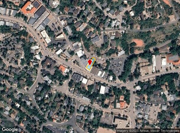
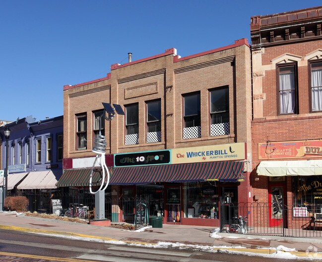
Property Record
742 Manitou Ave, Manitou Springs, CO 80829

NEARBY LISTINGS FOR SALE OR LEASE
Property Detail
742 Manitou Ave
Colorado Springs, CO
C R Standish Sub Of Part Blk C Manitou
74053-47-017
PART OF LOTS 7, 8 C R STANDISHS SUB OF LOTS 20, 21 + PART OF LOTS 19, 22, 23 BLK C MANITOU SPGS AS FOLS, BEG AT A PT ON MANITOU AVE 45 FT M/L NW OF SE COR OF LOT 8, TH NELY ALG SELY LN OF SD TR BEING DES 85.26 FT TO PT ON C/L OF FOUNTAIN CRK, TH ANG
Multifamilydwelling
El Paso
AE
Colorado
08041C0706G
7
2024
0.11 AC
2025
Southwest
006701
Colorado Springs
7,285 SF
DEMOGRAPHICS near 742 Manitou Ave
1 Mile
3 Mile
5 Mile
2024 Total Population
3,148
14,189
55,892
2029 Population
3,297
14,852
58,528
Pop Growth 2024-2029
+ 4.73%
+ 4.67%
+ 4.72%
Average Age
44
47
44
2024 Total Households
1,645
6,883
25,685
HH Growth 2024-2029
+ 4.92%
+ 4.98%
+ 5.00%
Median Household Inc
$73,217
$73,357
$72,532
Avg Household Size
1.90
2.00
2.10
2024 Avg HH Vehicles
2.00
2.00
2.00
Median Home Value
$542,154
$477,811
$466,052
Median Year Built
1947
1967
1978
Nearby Places
Map Layers
Map Styles
 Street
 Aerial
- Restaurants
- Banks
- Shops
- Fitness
- Groceries
PUBLIC TRANSPORTATION
AIRPORT
City of Colorado Springs Municipal
DRIVE
WALK
Distance
City of Colorado Springs Municipal
30 min
16.1 mi
Nearby Properties
Address
Land Use
TOTAL SIZE
Lot Size
Zoning
Address
Land Use
TOTAL SIZE
Lot Size
Zoning
2,422 SF
616.19 AC
PK MX-I PD
Address
Land Use
TOTAL SIZE
Lot Size
Zoning
75,349 SF
27.75 AC
EPC
Address
Land Use
TOTAL SIZE
Lot Size
Zoning
45,268 SF
8.37 AC
PDZ UV
Address
Land Use
TOTAL SIZE
Lot Size
Zoning
37,196 SF
3 AC
PDZ
Address
Land Use
TOTAL SIZE
Lot Size
Zoning
4.78 AC
R-T
Address
Land Use
TOTAL SIZE
Lot Size
Zoning
157,471 SF
0.02 AC
PUD,HS
Address
Land Use
TOTAL SIZE
Lot Size
Zoning
20,147 SF
38.98 AC
PK HS
Address
Land Use
TOTAL SIZE
Lot Size
Zoning
127.25 AC
PK HS
Address
Land Use
TOTAL SIZE
Lot Size
Zoning
34,296 SF
0.85 AC
Address
Land Use
TOTAL SIZE
Lot Size
Zoning
3,058 SF
28.22 AC
HLDR
Address
Land Use
TOTAL SIZE
Lot Size
Zoning
6,658 SF
189.56 AC
R-E PK HS
Address
Land Use
TOTAL SIZE
Lot Size
Zoning
14,263 SF
0.98 AC
R-2 R-5
Address
Land Use
TOTAL SIZE
Lot Size
Zoning
33,548 SF
3.80 AC
R-E
Address
Land Use
TOTAL SIZE
Lot Size
Zoning
4,062 SF
355.88 AC
PK HS
Address
Land Use
TOTAL SIZE
Lot Size
Zoning
15,964 SF
6.04 AC
R-2 HS CU
Address
Land Use
TOTAL SIZE
Lot Size
Zoning
24,433 SF
1.69 AC
R-1 6
Address
Land Use
TOTAL SIZE
Lot Size
Zoning
925 SF
3.55 AC
R-T
Address
Land Use
TOTAL SIZE
Lot Size
Zoning
38,885 SF
5.82 AC
R-1 6
Address
Land Use
TOTAL SIZE
Lot Size
Zoning
24,087 SF
1.25 AC
LI CU
Address
Land Use
TOTAL SIZE
Lot Size
Zoning
6,899 SF
2.77 AC
R-2 HS CU
Address
Land Use
TOTAL SIZE
Lot Size
Zoning
7,364 SF
0.34 AC
C
Address
Land Use
TOTAL SIZE
Lot Size
Zoning
72,616 SF
4.79 AC
BP HS CU
Address
Land Use
TOTAL SIZE
Lot Size
Zoning
625 SF
2.42 AC
GR
Address
Land Use
TOTAL SIZE
Lot Size
Zoning
21,989 SF
0.79 AC
Address
Land Use
TOTAL SIZE
Lot Size
Zoning
171.67 AC
PK
Address
Land Use
TOTAL SIZE
Lot Size
Zoning
30,532 SF
17.08 AC
GR
Address
Land Use
TOTAL SIZE
Lot Size
Zoning
14,248 SF
0.93 AC
C
Address
Land Use
TOTAL SIZE
Lot Size
Zoning
11,452 SF
2.12 AC
R-5 HS
Address
Land Use
TOTAL SIZE
Lot Size
Zoning
54,398 SF
1.20 AC
Address
Land Use
TOTAL SIZE
Lot Size
Zoning
122.07 AC
PK
The World's #1 Commercial Real Estate Marketplace
Connect with us
© 2025 CoStar Group
The information above has been obtained from sources believed reliable. While we do not doubt its accuracy we have not verified it and make no guarantee, warranty or representation about it. It is your responsibility to independently confirm its accuracy and completeness. Any projections, opinions, assumptions, or estimates used are for example only and do not represent the current or future performance of the property. The value of this transaction to you depends on tax and other factors which should be evaluated by your tax, financial, and legal advisors. You and your advisors should conduct a careful, independent investigation of the property to determine to your satisfaction the suitability of the property for your needs.