Property Record
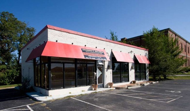
7420 Johnson Dr, Mission, KS 66202


Property Detail
7420 Johnson Dr
NF251207-3017
7-12-25 PT NE 1/4 PT OF TR BEGNE COR JO DR & FOSTER ST E 142.92 N 150 W TO PT ON E/L FOSTER ST S TO BG LYING WITHINMAIN SEW DIST BEING SLY 100 M/L EX TRI TR IN SW COR FOR HWY .323 ACS M/L OPC 230C
Restaurantbuilding
JOHNSON
C-2
Kansas
B and X Area of moderate flood hazard, usually the area between the limits of the 100-year and 500-year floods.
0.31 AC
2025
Northeast Johnson County
2025
Kansas City
050400
Kansas City, MO-KS
1,316 SF
NEARBY LISTINGS FOR SALE OR LEASE
DEMOGRAPHICS near 7420 Johnson Dr
1 mile
3 mile
5 mile
2025 Total Population
10,051
92,601
246,729
2030 Population
10,347
94,909
252,458
Pop Growth 2025-2030
+ 2.94%
+ 2.49%
+ 2.32%
Average Age
40
40
40
2025 Total Households
4,907
41,451
109,409
HH Growth 2025-2030
+ 3.14%
+ 2.69%
+ 2.48%
Median Household Inc
$72,395
$77,115
$83,392
Avg Household Size
2.00
2.20
2.20
2025 Avg HH Vehicles
2.00
2.00
2.00
Median Home Value
$278,689
$283,214
$324,824
Median Year Built
1963
1961
1963
Nearby Places
Map Layers
Map Styles
 Street
 Aerial
Layers
 Traffic
 Biking
Places
Listings with unknown addresses are not visible on the map
- Restaurants
- Banks
- Shops
- Fitness
- Groceries
PUBLIC TRANSPORTATION
COMMUTER RAIL
Kansas City (Lincoln Service Missouri River Runner - Amtrak, Missouri River Runner - Amtrak, Southwest Chief - Amtrak)
Drive
Walk
Distance
Kansas City (Lincoln Service Missouri River Runner - Amtrak, Missouri River Runner - Amtrak, Southwest Chief - Amtrak)
14 min
8.2 mi
AIRPORT
Kansas City International
Drive
Walk
Distance
Kansas City International
33 min
25.7 mi
Freight Ports
Tulsa Port Of Catoosa
Drive
Walk
Distance
Tulsa Port Of Catoosa
257 min
230.6 mi
Nearby Properties
Address
Land Use
TOTAL SIZE
Lot Size
Zoning
Address
Land Use
TOTAL SIZE
Lot Size
Zoning
857,568 SF
38.48 AC
PUD-G
Address
Land Use
TOTAL SIZE
Lot Size
Zoning
312,446 SF
39.35 AC
R-1
Address
Land Use
TOTAL SIZE
Lot Size
Zoning
34,649 SF
20.26 AC
R-1
Address
Land Use
TOTAL SIZE
Lot Size
Zoning
133,505 SF
16.41 AC
R-1
Address
Land Use
TOTAL SIZE
Lot Size
Zoning
213,073 SF
30.09 AC
PUB
Address
Land Use
TOTAL SIZE
Lot Size
Zoning
96,501 SF
6.49 AC
Address
Land Use
TOTAL SIZE
Lot Size
Zoning
74,212 SF
8.01 AC
R-1
Address
Land Use
TOTAL SIZE
Lot Size
Zoning
41,676 SF
18.45 AC
R-1
Address
Land Use
TOTAL SIZE
Lot Size
Zoning
89,477 SF
16.45 AC
R-1
Address
Land Use
TOTAL SIZE
Lot Size
Zoning
63,471 SF
7.36 AC
PARK
Address
Land Use
TOTAL SIZE
Lot Size
Zoning
42,597 SF
4.39 AC
MS2
Address
Land Use
TOTAL SIZE
Lot Size
Zoning
90,774 SF
1.73 AC
MS2
Address
Land Use
TOTAL SIZE
Lot Size
Zoning
79,437 SF
4.12 AC
DFD
Address
Land Use
TOTAL SIZE
Lot Size
Zoning
96,856 SF
15.76 AC
R-1
Address
Land Use
TOTAL SIZE
Lot Size
Zoning
99,812 SF
3.85 AC
R-1A
Address
Land Use
TOTAL SIZE
Lot Size
Zoning
65,932 SF
3.72 AC
PUD-G
Address
Land Use
TOTAL SIZE
Lot Size
Zoning
93,418 SF
12.07 AC
R-1
Address
Land Use
TOTAL SIZE
Lot Size
Zoning
124,249 SF
6.13 AC
R-1B
Address
Land Use
TOTAL SIZE
Lot Size
Zoning
109,798 SF
16.93 AC
R-1A
Address
Land Use
TOTAL SIZE
Lot Size
Zoning
70,952 SF
9.98 AC
R-1
Address
Land Use
TOTAL SIZE
Lot Size
Zoning
100,784 SF
4.68 AC
C-2B
Address
Land Use
TOTAL SIZE
Lot Size
Zoning
74,802 SF
10.55 AC
CP-O
Address
Land Use
TOTAL SIZE
Lot Size
Zoning
667,586 SF
18.06 AC
PUD-G
Address
Land Use
TOTAL SIZE
Lot Size
Zoning
311,454 SF
40.91 AC
PUD-G
Address
Land Use
TOTAL SIZE
Lot Size
Zoning
77,758 SF
4.89 AC
R-1
Address
Land Use
TOTAL SIZE
Lot Size
Zoning
82,035 SF
8.49 AC
R-1
Address
Land Use
TOTAL SIZE
Lot Size
Zoning
111,880 SF
36.74 AC
KR1
Address
Land Use
TOTAL SIZE
Lot Size
Zoning
77,648 SF
6.90 AC
R-1
Address
Land Use
TOTAL SIZE
Lot Size
Zoning
34,745 SF
8.96 AC
PARK
Address
Land Use
TOTAL SIZE
Lot Size
Zoning
62,452 SF
14.89 AC
KR1
The World's #1 Commercial Real Estate Marketplace
Connect with us
© 2026 CoStar Group
The information above has been obtained from sources believed reliable. While we do not doubt its accuracy we have not verified it and make no guarantee, warranty or representation about it. It is your responsibility to independently confirm its accuracy and completeness. Any projections, opinions, assumptions, or estimates used are for example only and do not represent the current or future performance of the property. The value of this transaction to you depends on tax and other factors which should be evaluated by your tax, financial, and legal advisors. You and your advisors should conduct a careful, independent investigation of the property to determine to your satisfaction the suitability of the property for your needs.