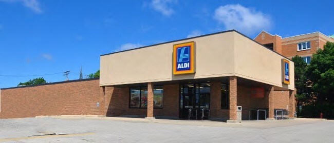
Property Record
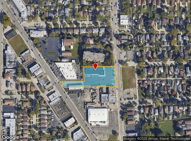
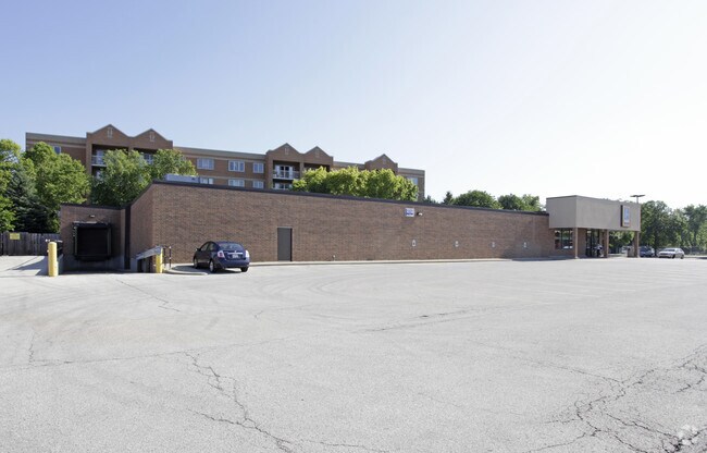
7420 N Waukegan Rd, Niles, IL 60714

NEARBY LISTINGS FOR SALE OR LEASE
Property Detail
7420 N Waukegan Rd
10-30-301-050-0000
Aldi Inc Sub
Commercialbuilding
Cook
X
Illinois
17031C0243J
1
2023
1.49 AC
2024
Near North
805401
Chicago
12,311 SF
Chicago-Naperville-Elgin, IL-IN-WI
DEMOGRAPHICS near 7420 N Waukegan Rd
1 Mile
3 Mile
5 Mile
2024 Total Population
16,694
169,164
476,270
2029 Population
16,172
163,423
460,250
Pop Growth 2024-2029
(3.13%)
(3.39%)
(3.36%)
Average Age
45
43
43
2024 Total Households
6,339
63,394
178,294
HH Growth 2024-2029
(3.49%)
(3.76%)
(3.69%)
Median Household Inc
$94,554
$97,411
$85,653
Avg Household Size
2.50
2.60
2.60
2024 Avg HH Vehicles
2.00
2.00
2.00
Median Home Value
$367,581
$381,353
$360,450
Median Year Built
1957
1957
1958
Nearby Places
Map Layers
Map Styles
 Street
 Aerial
- Restaurants
- Banks
- Shops
- Fitness
- Groceries
PUBLIC TRANSPORTATION
COMMUTER RAIL
Park Ridge Station (Union Pacific Northwest Line - Northeast Illinois Regional Commuter Railroad (Metra))
DRIVE
WALK
Distance
Park Ridge Station (Union Pacific Northwest Line - Northeast Illinois Regional Commuter Railroad (Metra))
4 min
1.8 mi
Edison Park Station (Union Pacific Northwest Line - Northeast Illinois Regional Commuter Railroad (Metra))
DRIVE
WALK
Distance
Edison Park Station (Union Pacific Northwest Line - Northeast Illinois Regional Commuter Railroad (Metra))
5 min
2.0 mi
AIRPORT
Chicago O'Hare International
DRIVE
WALK
Distance
Chicago O'Hare International
14 min
7.6 mi
Chicago Midway International
DRIVE
WALK
Distance
Chicago Midway International
32 min
17.5 mi
Freight Ports
Port Milwaukee
DRIVE
WALK
Distance
Port Milwaukee
89 min
74.7 mi
Nearby Properties
Address
Land Use
TOTAL SIZE
Lot Size
Zoning
Address
Land Use
TOTAL SIZE
Lot Size
Zoning
203,090 SF
7.96 AC
Address
Land Use
TOTAL SIZE
Lot Size
Zoning
697,000 SF
11.60 AC
PD 71
Address
Land Use
TOTAL SIZE
Lot Size
Zoning
24.49 AC
Address
Land Use
TOTAL SIZE
Lot Size
Zoning
555,681 SF
7.36 AC
PD 340
Address
Land Use
TOTAL SIZE
Lot Size
Zoning
39.26 AC
Address
Land Use
TOTAL SIZE
Lot Size
Zoning
248,726 SF
11.79 AC
PD 44
Address
Land Use
TOTAL SIZE
Lot Size
Zoning
188,728 SF
Address
Land Use
TOTAL SIZE
Lot Size
Zoning
10.24 AC
Address
Land Use
TOTAL SIZE
Lot Size
Zoning
414,878 SF
20.79 AC
Address
Land Use
TOTAL SIZE
Lot Size
Zoning
246,000 SF
2.29 AC
PD 340
Address
Land Use
TOTAL SIZE
Lot Size
Zoning
315,373 SF
26.19 AC
Address
Land Use
TOTAL SIZE
Lot Size
Zoning
9.38 AC
PD 1179,PO
Address
Land Use
TOTAL SIZE
Lot Size
Zoning
269,500 SF
11.03 AC
Address
Land Use
TOTAL SIZE
Lot Size
Zoning
103,323 SF
10.65 AC
Address
Land Use
TOTAL SIZE
Lot Size
Zoning
172,500 SF
2.42 AC
Address
Land Use
TOTAL SIZE
Lot Size
Zoning
16.27 AC
Address
Land Use
TOTAL SIZE
Lot Size
Zoning
43,765 SF
2.79 AC
Address
Land Use
TOTAL SIZE
Lot Size
Zoning
322,805 SF
Address
Land Use
TOTAL SIZE
Lot Size
Zoning
486,884 SF
16.41 AC
Address
Land Use
TOTAL SIZE
Lot Size
Zoning
450,768 SF
6.97 AC
Address
Land Use
TOTAL SIZE
Lot Size
Zoning
552,152 SF
7.88 AC
Address
Land Use
TOTAL SIZE
Lot Size
Zoning
231,865 SF
3.16 AC
Address
Land Use
TOTAL SIZE
Lot Size
Zoning
5.60 AC
Address
Land Use
TOTAL SIZE
Lot Size
Zoning
13.13 AC
Address
Land Use
TOTAL SIZE
Lot Size
Zoning
320,535 SF
12.44 AC
Address
Land Use
TOTAL SIZE
Lot Size
Zoning
166,728 SF
11.79 AC
Address
Land Use
TOTAL SIZE
Lot Size
Zoning
167,156 SF
6.23 AC
B3-1
Address
Land Use
TOTAL SIZE
Lot Size
Zoning
195,849 SF
6.55 AC
Address
Land Use
TOTAL SIZE
Lot Size
Zoning
92,457 SF
4.09 AC
Address
Land Use
TOTAL SIZE
Lot Size
Zoning
629,244 SF
11.07 AC
RS-2
The World's #1 Commercial Real Estate Marketplace
Connect with us
© 2025 CoStar Group
The information above has been obtained from sources believed reliable. While we do not doubt its accuracy we have not verified it and make no guarantee, warranty or representation about it. It is your responsibility to independently confirm its accuracy and completeness. Any projections, opinions, assumptions, or estimates used are for example only and do not represent the current or future performance of the property. The value of this transaction to you depends on tax and other factors which should be evaluated by your tax, financial, and legal advisors. You and your advisors should conduct a careful, independent investigation of the property to determine to your satisfaction the suitability of the property for your needs.