Property Record
7420 Standifer Gap Rd, Chattanooga, TN 37421

NEARBY LISTINGS FOR SALE OR LEASE
-
-
View all Chattanooga listings for sale on LoopNet.com
Property Detail
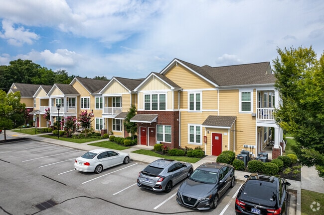
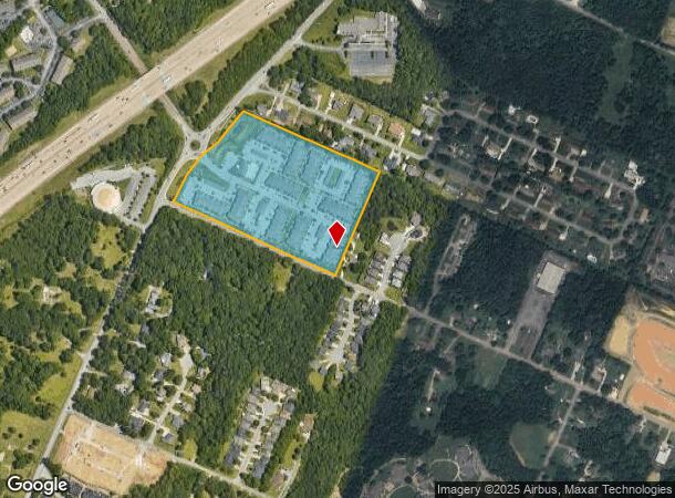
7420 Standifer Gap Rd
Chattanooga, TN-GA
Varnell Farms
149B-A-024
LT 1 VARNELL FARMS PB12 PG17 REV 99-41 SPRINGS OF CHATTANOOGA HUNTERS POINT 260 UNITS 42- STUDIO UNITS 88- 1 BR UNITS 108- 2
Highriseapartments
Hamilton
X
Tennessee
47065C0367G
1
2025
14.41 AC
2025
Westview-Mountain Shadows
011321
Chattanooga
23,078 SF
DEMOGRAPHICS near 7420 Standifer Gap Rd
1 Mile
3 Mile
5 Mile
2024 Total Population
6,953
42,739
97,772
2029 Population
7,399
45,589
103,833
Pop Growth 2024-2029
+ 6.41%
+ 6.67%
+ 6.20%
Average Age
44
42
41
2024 Total Households
3,255
17,478
39,227
HH Growth 2024-2029
+ 6.73%
+ 6.85%
+ 6.38%
Median Household Inc
$64,647
$70,620
$71,630
Avg Household Size
2.00
2.30
2.40
2024 Avg HH Vehicles
2.00
2.00
2.00
Median Home Value
$259,627
$242,814
$245,464
Median Year Built
2000
1991
1987
Nearby Places
Map Layers
Map Styles
 Street
 Aerial
- Restaurants
- Banks
- Shops
- Fitness
- Groceries
PUBLIC TRANSPORTATION
AIRPORT
Lovell Field
DRIVE
WALK
Distance
Lovell Field
14 min
6.0 mi
Freight Ports
Georgia Ports - Savannah
DRIVE
WALK
Distance
Georgia Ports - Savannah
408 min
363.2 mi
Nearby Properties
Address
Land Use
TOTAL SIZE
Lot Size
Zoning
Address
Land Use
TOTAL SIZE
Lot Size
Zoning
2,025,141 SF
1,096 AC
M1
Address
Land Use
TOTAL SIZE
Lot Size
Zoning
0.06 AC
M1
Address
Land Use
TOTAL SIZE
Lot Size
Zoning
523,520 SF
12.03 AC
M1
Address
Land Use
TOTAL SIZE
Lot Size
Zoning
440,611 SF
27.46 AC
C2
Address
Land Use
TOTAL SIZE
Lot Size
Zoning
292,309 SF
45.28 AC
M1
Address
Land Use
TOTAL SIZE
Lot Size
Zoning
1,015,740 SF
83.82 AC
M1
Address
Land Use
TOTAL SIZE
Lot Size
Zoning
117,007 SF
23.87 AC
R4
Address
Land Use
TOTAL SIZE
Lot Size
Zoning
333,801 SF
15.44 AC
C2
Address
Land Use
TOTAL SIZE
Lot Size
Zoning
242,788 SF
27 AC
Address
Land Use
TOTAL SIZE
Lot Size
Zoning
4,418 SF
18.01 AC
R3
Address
Land Use
TOTAL SIZE
Lot Size
Zoning
287,820 SF
13.33 AC
R3
Address
Land Use
TOTAL SIZE
Lot Size
Zoning
320,068 SF
42.83 AC
R4
Address
Land Use
TOTAL SIZE
Lot Size
Zoning
402,862 SF
26.14 AC
R1
Address
Land Use
TOTAL SIZE
Lot Size
Zoning
43,488 SF
27.72 AC
R3
Address
Land Use
TOTAL SIZE
Lot Size
Zoning
25,436 SF
21.34 AC
R3
Address
Land Use
TOTAL SIZE
Lot Size
Zoning
333,768 SF
15.38 AC
C4
Address
Land Use
TOTAL SIZE
Lot Size
Zoning
43,576 SF
6.66 AC
C2
Address
Land Use
TOTAL SIZE
Lot Size
Zoning
218,244 SF
16.33 AC
Address
Land Use
TOTAL SIZE
Lot Size
Zoning
25,462 SF
16.20 AC
R1
Address
Land Use
TOTAL SIZE
Lot Size
Zoning
3,472 SF
14.01 AC
Address
Land Use
TOTAL SIZE
Lot Size
Zoning
97,000 SF
18.78 AC
Address
Land Use
TOTAL SIZE
Lot Size
Zoning
23,124 SF
27.23 AC
A
Address
Land Use
TOTAL SIZE
Lot Size
Zoning
25,165 SF
21.90 AC
Address
Land Use
TOTAL SIZE
Lot Size
Zoning
102,382 SF
29.80 AC
M2
Address
Land Use
TOTAL SIZE
Lot Size
Zoning
237,764 SF
60.56 AC
Address
Land Use
TOTAL SIZE
Lot Size
Zoning
99,202 SF
17.32 AC
Address
Land Use
TOTAL SIZE
Lot Size
Zoning
129,710 SF
4.55 AC
R1
Address
Land Use
TOTAL SIZE
Lot Size
Zoning
82,000 SF
22.45 AC
M1
Address
Land Use
TOTAL SIZE
Lot Size
Zoning
201,276 SF
15.30 AC
R3
The World's #1 Commercial Real Estate Marketplace
Connect with us
© 2026 CoStar Group
The information above has been obtained from sources believed reliable. While we do not doubt its accuracy we have not verified it and make no guarantee, warranty or representation about it. It is your responsibility to independently confirm its accuracy and completeness. Any projections, opinions, assumptions, or estimates used are for example only and do not represent the current or future performance of the property. The value of this transaction to you depends on tax and other factors which should be evaluated by your tax, financial, and legal advisors. You and your advisors should conduct a careful, independent investigation of the property to determine to your satisfaction the suitability of the property for your needs.