Property Record
7420 Sw Bridgeport Rd, Portland, OR 97224
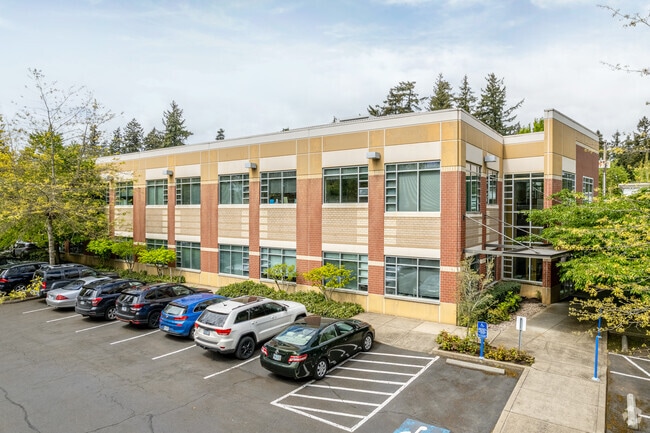

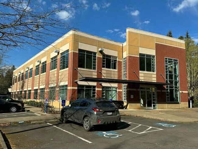

Property Detail
7420 Sw Bridgeport Rd
R0516454
TUALATIN VALLEY HOMES, LOT PT 72, ACRES 1.13
Commercialbuilding
Washington
MUC
Oregon
B and X Area of moderate flood hazard, usually the area between the limits of the 100-year and 500-year floods.
72
2024
1.13 AC
2026
Tigard
032005
Portland
29,606 SF
Portland-Vancouver-Hillsboro, OR-WA
NEARBY LISTINGS FOR SALE OR LEASE
DEMOGRAPHICS near 7420 Sw Bridgeport Rd
1 mile
3 mile
5 mile
2025 Total Population
7,595
92,528
209,436
2030 Population
7,642
93,387
210,735
Pop Growth 2025-2030
+ 0.62%
+ 0.93%
+ 0.62%
Average Age
40
43
42
2025 Total Households
3,318
37,488
83,485
HH Growth 2025-2030
+ 0.84%
+ 1.05%
+ 0.65%
Median Household Inc
$105,761
$107,586
$111,423
Avg Household Size
2.30
2.40
2.40
2025 Avg HH Vehicles
2.00
2.00
2.00
Median Home Value
$729,564
$703,903
$707,916
Median Year Built
1991
1985
1986
Nearby Places
Map Layers
Map Styles
 Street
 Aerial
Transit
 Traffic
 Biking
Places
Listings with unknown addresses are not visible on the map
- Restaurants
- Banks
- Shops
- Fitness
- Groceries
SALE & LEASE HISTORY
LISTING DATE
SALE/LEASE

Oct 14, 2022
For Lease
Jun 29, 2021
For Lease
Jul 31, 2024
For Lease
Jul 08, 2020
For Lease
Apr 23, 2024
For Sale
Nearby Properties
Address
Land Use
TOTAL SIZE
Lot Size
Zoning
Address
Land Use
TOTAL SIZE
Lot Size
Zoning
49.34 AC
I-P
Address
Land Use
TOTAL SIZE
Lot Size
Zoning
511,394 SF
18.68 AC
MUC
Address
Land Use
TOTAL SIZE
Lot Size
Zoning
Address
Land Use
TOTAL SIZE
Lot Size
Zoning
1 SF
16 AC
R-5
Address
Land Use
TOTAL SIZE
Lot Size
Zoning
Address
Land Use
TOTAL SIZE
Lot Size
Zoning
43.20 AC
R-4.5
Address
Land Use
TOTAL SIZE
Lot Size
Zoning
216,381 SF
24.95 AC
CG
Address
Land Use
TOTAL SIZE
Lot Size
Zoning
14.77 AC
MUE
Address
Land Use
TOTAL SIZE
Lot Size
Zoning
216,000 SF
64.68 AC
RL
Address
Land Use
TOTAL SIZE
Lot Size
Zoning
27.23 AC
MP
Address
Land Use
TOTAL SIZE
Lot Size
Zoning
88,000 SF
15.49 AC
R-4.5
Address
Land Use
TOTAL SIZE
Lot Size
Zoning
0.14 AC
MG
Address
Land Use
TOTAL SIZE
Lot Size
Zoning
20.82 AC
R-5
Address
Land Use
TOTAL SIZE
Lot Size
Zoning
6 AC
MC
Address
Land Use
TOTAL SIZE
Lot Size
Zoning
183,133 SF
8.17 AC
R-25
Address
Land Use
TOTAL SIZE
Lot Size
Zoning
Address
Land Use
TOTAL SIZE
Lot Size
Zoning
174,043 SF
20.35 AC
CC
Address
Land Use
TOTAL SIZE
Lot Size
Zoning
4 AC
MC
Address
Land Use
TOTAL SIZE
Lot Size
Zoning
18 AC
RMH
Address
Land Use
TOTAL SIZE
Lot Size
Zoning
10.81 AC
RH
Address
Land Use
TOTAL SIZE
Lot Size
Zoning
190,012 SF
4.59 AC
IP
Address
Land Use
TOTAL SIZE
Lot Size
Zoning
88,000 SF
12.62 AC
R-4.5
Address
Land Use
TOTAL SIZE
Lot Size
Zoning
294,220 SF
15.10 AC
RH
Address
Land Use
TOTAL SIZE
Lot Size
Zoning
301,940 SF
15.04 AC
MU-CBD
Address
Land Use
TOTAL SIZE
Lot Size
Zoning
71,930 SF
22.68 AC
CO
Address
Land Use
TOTAL SIZE
Lot Size
Zoning
Address
Land Use
TOTAL SIZE
Lot Size
Zoning
68,450 SF
19.39 AC
ML
Address
Land Use
TOTAL SIZE
Lot Size
Zoning
121,664 SF
11.65 AC
C-G
The World's #1 Commercial Real Estate Marketplace
Connect with us
© 2026 CoStar Group
The information above has been obtained from sources believed reliable. While we do not doubt its accuracy we have not verified it and make no guarantee, warranty or representation about it. It is your responsibility to independently confirm its accuracy and completeness. Any projections, opinions, assumptions, or estimates used are for example only and do not represent the current or future performance of the property. The value of this transaction to you depends on tax and other factors which should be evaluated by your tax, financial, and legal advisors. You and your advisors should conduct a careful, independent investigation of the property to determine to your satisfaction the suitability of the property for your needs.