Property Record
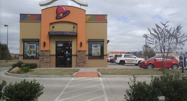
7422 S Sam Houston Pkwy W, Houston, TX 77085

NEARBY LISTINGS FOR SALE OR LEASE
Property Detail
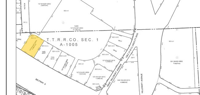
7422 S Sam Houston Pkwy W
1278140010005
Crossings At Fort Bend Parkway
Restaurantdrivein
RES A2 BLK 1 CROSSINGS AT FORT BEND PARKWAY
X
Harris
48157C0305M
Texas
2024
1.10 AC
2025
Near SW Central
330303
Houston
1,946 SF
Houston-Pasadena-The Woodlands, TX
DEMOGRAPHICS near 7422 S Sam Houston Pkwy W
1 Mile
3 Mile
5 Mile
2024 Total Population
8,719
126,807
315,203
2029 Population
9,852
138,482
343,230
Pop Growth 2024-2029
+ 12.99%
+ 9.21%
+ 8.89%
Average Age
38
37
37
2024 Total Households
3,073
41,545
108,297
HH Growth 2024-2029
+ 13.18%
+ 9.31%
+ 8.93%
Median Household Inc
$54,142
$54,038
$57,803
Avg Household Size
2.80
3.00
2.80
2024 Avg HH Vehicles
2.00
2.00
2.00
Median Home Value
$147,580
$157,529
$197,289
Median Year Built
1988
1980
1979
Nearby Places
Map Layers
Map Styles
 Street
 Aerial
- Restaurants
- Banks
- Shops
- Fitness
- Groceries
PUBLIC TRANSPORTATION
AIRPORT
William P Hobby
DRIVE
WALK
Distance
William P Hobby
30 min
16.9 mi
George Bush Intcntl/Houston
DRIVE
WALK
Distance
George Bush Intcntl/Houston
49 min
34.6 mi
Freight Ports
Port of Houston
DRIVE
WALK
Distance
Port of Houston
33 min
20.9 mi
SALE & LEASE HISTORY
LISTING DATE
SALE/LEASE

Sep 08, 2023
For Sale
Nearby Properties
Address
Land Use
TOTAL SIZE
Lot Size
Zoning
Address
Land Use
TOTAL SIZE
Lot Size
Zoning
1,139,160 SF
75.11 AC
Address
Land Use
TOTAL SIZE
Lot Size
Zoning
257,051 SF
64.85 AC
Address
Land Use
TOTAL SIZE
Lot Size
Zoning
552,900 SF
27.86 AC
Address
Land Use
TOTAL SIZE
Lot Size
Zoning
967,659 SF
75.03 AC
Address
Land Use
TOTAL SIZE
Lot Size
Zoning
344,620 SF
53.65 AC
STHQZ
Address
Land Use
TOTAL SIZE
Lot Size
Zoning
35.85 AC
Address
Land Use
TOTAL SIZE
Lot Size
Zoning
305,512 SF
13.74 AC
Address
Land Use
TOTAL SIZE
Lot Size
Zoning
429,368 SF
27.94 AC
Address
Land Use
TOTAL SIZE
Lot Size
Zoning
428,538 SF
45.50 AC
Address
Land Use
TOTAL SIZE
Lot Size
Zoning
93,310 SF
13.41 AC
Address
Land Use
TOTAL SIZE
Lot Size
Zoning
534,800 SF
33.43 AC
Address
Land Use
TOTAL SIZE
Lot Size
Zoning
Address
Land Use
TOTAL SIZE
Lot Size
Zoning
382,505 SF
21.68 AC
Address
Land Use
TOTAL SIZE
Lot Size
Zoning
456,076 SF
19.09 AC
Address
Land Use
TOTAL SIZE
Lot Size
Zoning
423,270 SF
32.95 AC
Address
Land Use
TOTAL SIZE
Lot Size
Zoning
490,720 SF
26.78 AC
S
Address
Land Use
TOTAL SIZE
Lot Size
Zoning
Address
Land Use
TOTAL SIZE
Lot Size
Zoning
371,335 SF
31.65 AC
Address
Land Use
TOTAL SIZE
Lot Size
Zoning
383,515 SF
12.61 AC
Address
Land Use
TOTAL SIZE
Lot Size
Zoning
391,473 SF
17.11 AC
Address
Land Use
TOTAL SIZE
Lot Size
Zoning
186,759 SF
42.60 AC
Address
Land Use
TOTAL SIZE
Lot Size
Zoning
18.23 AC
Address
Land Use
TOTAL SIZE
Lot Size
Zoning
39.26 AC
Address
Land Use
TOTAL SIZE
Lot Size
Zoning
24.49 AC
QSY
Address
Land Use
TOTAL SIZE
Lot Size
Zoning
240,000 SF
12.45 AC
Address
Land Use
TOTAL SIZE
Lot Size
Zoning
306,103 SF
64.07 AC
QY
Address
Land Use
TOTAL SIZE
Lot Size
Zoning
21.84 AC
QSY
Address
Land Use
TOTAL SIZE
Lot Size
Zoning
294,941 SF
18.86 AC
Address
Land Use
TOTAL SIZE
Lot Size
Zoning
240,853 SF
19.07 AC
Address
Land Use
TOTAL SIZE
Lot Size
Zoning
217,000 SF
10.47 AC
The World's #1 Commercial Real Estate Marketplace
Connect with us
© 2026 CoStar Group
The information above has been obtained from sources believed reliable. While we do not doubt its accuracy we have not verified it and make no guarantee, warranty or representation about it. It is your responsibility to independently confirm its accuracy and completeness. Any projections, opinions, assumptions, or estimates used are for example only and do not represent the current or future performance of the property. The value of this transaction to you depends on tax and other factors which should be evaluated by your tax, financial, and legal advisors. You and your advisors should conduct a careful, independent investigation of the property to determine to your satisfaction the suitability of the property for your needs.