No Photo
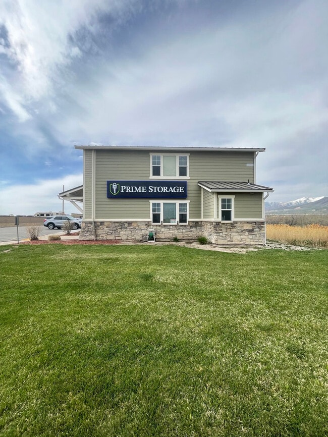
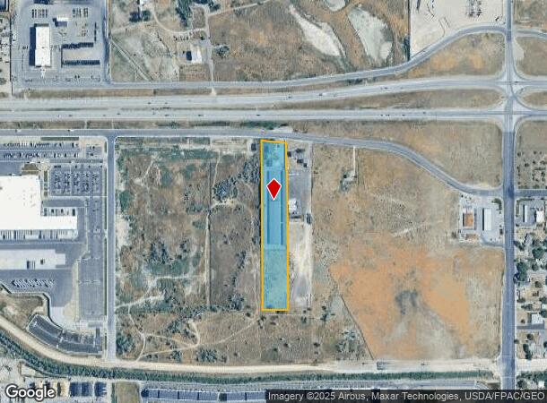
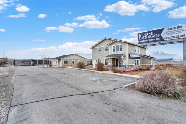
Property Record
7425 W Utwo O One Hwy, Magna, UT 84044
Current Lease Availabilities
NEARBY LISTINGS FOR SALE OR LEASE
Property Detail
7425 W Utwo O One Hwy
14-21-402-001-0000
Radius Curve
Publicstorage
BEG S 895832 W 1650 FT & S 00913 E 167.20 FT FR E 1/4 COR SEC 21, T1S, R2W, SLM; SELY ALG 5699.60 FT RADIUS CURVER 161.54 FT (CHD S 853745 E 161.53 FT); S 00913 E 185.47 FT; N 895047 E 3.97 FT; S 00913 E 922.28 FT; S 895620 W 165 FT; N 00913 W 1120.2
X
Salt Lake
49035C0275G
Utah
2024
4.20 AC
2025
West Valley/Lake Park
113904
Salt Lake City
57,862 SF
Salt Lake City, UT
DEMOGRAPHICS near 7425 W Utwo O One Hwy
1 Mile
3 Mile
5 Mile
2024 Total Population
5,657
56,654
109,339
2029 Population
5,734
56,920
109,856
Pop Growth 2024-2029
+ 1.36%
+ 0.47%
+ 0.47%
Average Age
33
34
35
2024 Total Households
1,563
15,810
30,144
HH Growth 2024-2029
+ 1.28%
+ 0.34%
+ 0.34%
Median Household Inc
$86,339
$80,178
$79,167
Avg Household Size
3.50
3.50
3.50
2024 Avg HH Vehicles
3.00
2.00
2.00
Median Home Value
$359,592
$337,200
$339,489
Median Year Built
1996
1989
1982
Nearby Places
- Restaurants
- Banks
- Shops
- Fitness
- Groceries
Nearby Properties
Address
Land Use
TOTAL SIZE
Lot Size
Zoning
Address
Land Use
TOTAL SIZE
Lot Size
Zoning
906,418 SF
46.97 AC
IP-M-1
Address
Land Use
TOTAL SIZE
Lot Size
Zoning
432,730 SF
13.03 AC
R-M
Address
Land Use
TOTAL SIZE
Lot Size
Zoning
634,402 SF
32.29 AC
IP-M
Address
Land Use
TOTAL SIZE
Lot Size
Zoning
529,870 SF
13.35 AC
R-M
Address
Land Use
TOTAL SIZE
Lot Size
Zoning
479,807 SF
13.13 AC
P-C
Address
Land Use
TOTAL SIZE
Lot Size
Zoning
832,383 SF
19.61 AC
IP-M
Address
Land Use
TOTAL SIZE
Lot Size
Zoning
89,037 SF
11.79 AC
C-2
Address
Land Use
TOTAL SIZE
Lot Size
Zoning
480,159 SF
56.52 AC
M-1
Address
Land Use
TOTAL SIZE
Lot Size
Zoning
98,479 SF
49.57 AC
M-1
Address
Land Use
TOTAL SIZE
Lot Size
Zoning
387,633 SF
24 AC
M-1
Address
Land Use
TOTAL SIZE
Lot Size
Zoning
404,800 SF
24.62 AC
M
Address
Land Use
TOTAL SIZE
Lot Size
Zoning
348,300 SF
18.50 AC
M-1
Address
Land Use
TOTAL SIZE
Lot Size
Zoning
496,431 SF
23.89 AC
IP-M
Address
Land Use
TOTAL SIZE
Lot Size
Zoning
229,578 SF
27.42 AC
M--1
Address
Land Use
TOTAL SIZE
Lot Size
Zoning
172,016 SF
622.03 AC
M-2
Address
Land Use
TOTAL SIZE
Lot Size
Zoning
198,063 SF
12.90 AC
M
Address
Land Use
TOTAL SIZE
Lot Size
Zoning
418,984 SF
21.65 AC
IP-M
Address
Land Use
TOTAL SIZE
Lot Size
Zoning
159,381 SF
18.82 AC
1106
Address
Land Use
TOTAL SIZE
Lot Size
Zoning
131,500 SF
75.92 AC
R-1-10
Address
Land Use
TOTAL SIZE
Lot Size
Zoning
856,805 SF
782.87 AC
A-20
Address
Land Use
TOTAL SIZE
Lot Size
Zoning
374,120 SF
22.16 AC
IP-M
Address
Land Use
TOTAL SIZE
Lot Size
Zoning
54,033 SF
7.28 AC
R-M
Address
Land Use
TOTAL SIZE
Lot Size
Zoning
231,694 SF
20.73 AC
1206
Address
Land Use
TOTAL SIZE
Lot Size
Zoning
328,670 SF
16.27 AC
M-1
Address
Land Use
TOTAL SIZE
Lot Size
Zoning
265,388 SF
14.97 AC
CG
Address
Land Use
TOTAL SIZE
Lot Size
Zoning
328,000 SF
18.04 AC
IP-M
Address
Land Use
TOTAL SIZE
Lot Size
Zoning
241,328 SF
13.26 AC
CG
Address
Land Use
TOTAL SIZE
Lot Size
Zoning
133,174 SF
51.71 AC
M-1
Address
Land Use
TOTAL SIZE
Lot Size
Zoning
58,759 SF
9.82 AC
RM/ZC
Address
Land Use
TOTAL SIZE
Lot Size
Zoning
99,064 SF
5.65 AC
1P-M
The World's #1 Commercial Real Estate Marketplace
Connect with us
© 2025 CoStar Group
The information above has been obtained from sources believed reliable. While we do not doubt its accuracy we have not verified it and make no guarantee, warranty or representation about it. It is your responsibility to independently confirm its accuracy and completeness. Any projections, opinions, assumptions, or estimates used are for example only and do not represent the current or future performance of the property. The value of this transaction to you depends on tax and other factors which should be evaluated by your tax, financial, and legal advisors. You and your advisors should conduct a careful, independent investigation of the property to determine to your satisfaction the suitability of the property for your needs.