Property Record
7426 Us Highway 64 E, Ramseur, NC 27316
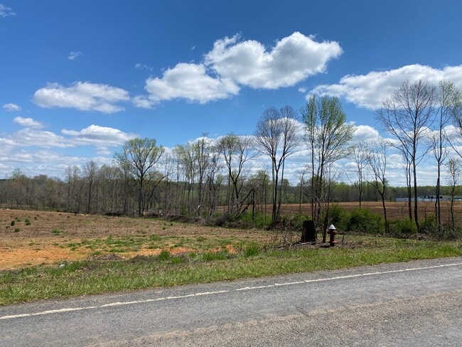

This Property Is For Sale
Property Detail
7426 Us Highway 64 E
8712-15-8066
CHAD CARMAC & JAMES S CONWAY TR:1 PL:144-6
Vacantlandnec
RANDOLPH
RA
North Carolina
AE The base floodplain where base flood elevations are provided. AE Zones are now used on new format FIRMs instead of A1-A30 Zones.
79.12 AC
2025
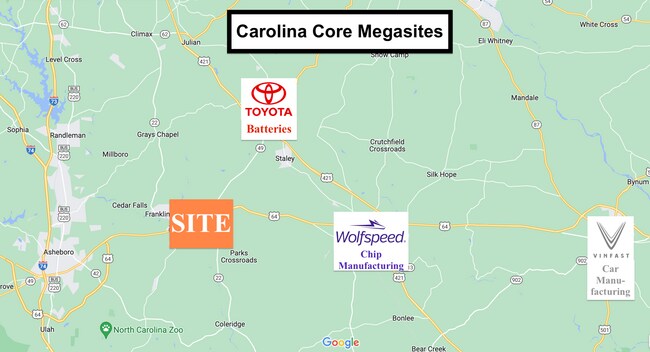
SE Randolph County
2025
Greensboro/Winston-Salem
031001
Greensboro-High Point, NC
NEARBY LISTINGS FOR SALE OR LEASE
DEMOGRAPHICS near 7426 Us Highway 64 E
1 mile
3 mile
5 mile
2025 Total Population
1,164
5,415
11,191
2030 Population
1,180
5,564
11,514
Pop Growth 2025-2030
+ 1.37%
+ 2.75%
+ 2.89%
Average Age
42
41
41
2025 Total Households
432
2,108
4,325
HH Growth 2025-2030
+ 1.39%
+ 2.89%
+ 2.94%
Median Household Inc
$48,026
$47,446
$56,132
Avg Household Size
2.50
2.50
2.50
2025 Avg HH Vehicles
2.00
2.00
2.00
Median Home Value
$179,545
$163,093
$185,763
Median Year Built
1973
1976
1982
Nearby Places
Map Layers
Map Styles
 Street
 Aerial
Layers
 Traffic
 Biking
Places
Listings with unknown addresses are not visible on the map
- Restaurants
- Banks
- Shops
- Fitness
- Groceries
PUBLIC TRANSPORTATION
AIRPORT
Piedmont Triad International
Drive
Walk
Distance
Piedmont Triad International
53 min
37.4 mi
Freight Ports
Port of Wilmington
Drive
Walk
Distance
Port of Wilmington
225 min
163.6 mi
Nearby Properties
Address
Land Use
TOTAL SIZE
Lot Size
Zoning
Address
Land Use
TOTAL SIZE
Lot Size
Zoning
1,388 SF
75.55 AC
RR
Address
Land Use
TOTAL SIZE
Lot Size
Zoning
2,720 SF
138.57 AC
NR
Address
Land Use
TOTAL SIZE
Lot Size
Zoning
39,739 SF
10.60 AC
RA-20
Address
Land Use
TOTAL SIZE
Lot Size
Zoning
4.97 AC
I&C
Address
Land Use
TOTAL SIZE
Lot Size
Zoning
72,000 SF
42.04 AC
LI
Address
Land Use
TOTAL SIZE
Lot Size
Zoning
43,348 SF
39.10 AC
RR
Address
Land Use
TOTAL SIZE
Lot Size
Zoning
38,612 SF
3.83 AC
B
Address
Land Use
TOTAL SIZE
Lot Size
Zoning
38,612 SF
3.76 AC
B
Address
Land Use
TOTAL SIZE
Lot Size
Zoning
11,620 SF
3.61 AC
RA
Address
Land Use
TOTAL SIZE
Lot Size
Zoning
54,690 SF
11.78 AC
I
Address
Land Use
TOTAL SIZE
Lot Size
Zoning
6,288 SF
4.30 AC
RA-16
Address
Land Use
TOTAL SIZE
Lot Size
Zoning
4,752 SF
4.30 AC
B
Address
Land Use
TOTAL SIZE
Lot Size
Zoning
66,166 SF
72.25 AC
I
Address
Land Use
TOTAL SIZE
Lot Size
Zoning
5,336 SF
1.95 AC
B
Address
Land Use
TOTAL SIZE
Lot Size
Zoning
10,806 SF
2.72 AC
B
Address
Land Use
TOTAL SIZE
Lot Size
Zoning
23,960 SF
12.92 AC
I
Address
Land Use
TOTAL SIZE
Lot Size
Zoning
20,720 SF
1.57 AC
I&C
Address
Land Use
TOTAL SIZE
Lot Size
Zoning
13,460 SF
0.85 AC
I&C
Address
Land Use
TOTAL SIZE
Lot Size
Zoning
3,938 SF
2.26 AC
B
Address
Land Use
TOTAL SIZE
Lot Size
Zoning
4,800 SF
97.60 AC
RA
Address
Land Use
TOTAL SIZE
Lot Size
Zoning
9,360 SF
10.03 AC
LI-CD
Address
Land Use
TOTAL SIZE
Lot Size
Zoning
43,848 SF
17.21 AC
I
Address
Land Use
TOTAL SIZE
Lot Size
Zoning
8,660 SF
0.20 AC
I&C
Address
Land Use
TOTAL SIZE
Lot Size
Zoning
9,842 SF
0.87 AC
NB
Address
Land Use
TOTAL SIZE
Lot Size
Zoning
6,912 SF
10.47 AC
HC
Address
Land Use
TOTAL SIZE
Lot Size
Zoning
25.81 AC
RM
Address
Land Use
TOTAL SIZE
Lot Size
Zoning
9,000 SF
3.37 AC
B
Address
Land Use
TOTAL SIZE
Lot Size
Zoning
8,368 SF
1.63 AC
B
Address
Land Use
TOTAL SIZE
Lot Size
Zoning
9,843 SF
1.50 AC
B
Address
Land Use
TOTAL SIZE
Lot Size
Zoning
7,684 SF
2.50 AC
B
The World's #1 Commercial Real Estate Marketplace
Connect with us
© 2026 CoStar Group
The information above has been obtained from sources believed reliable. While we do not doubt its accuracy we have not verified it and make no guarantee, warranty or representation about it. It is your responsibility to independently confirm its accuracy and completeness. Any projections, opinions, assumptions, or estimates used are for example only and do not represent the current or future performance of the property. The value of this transaction to you depends on tax and other factors which should be evaluated by your tax, financial, and legal advisors. You and your advisors should conduct a careful, independent investigation of the property to determine to your satisfaction the suitability of the property for your needs.