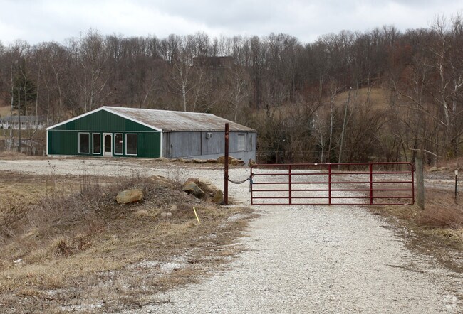
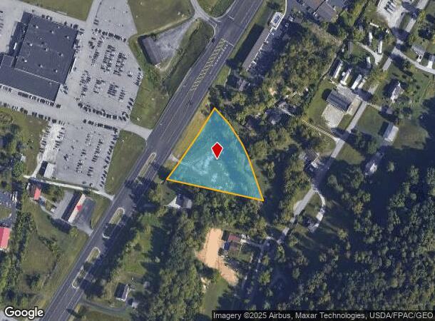
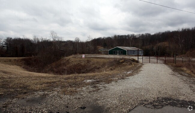
Property Record
7426 Us Route 60 Rte, Ashland, KY 41102
NEARBY LISTINGS FOR SALE OR LEASE
Property Detail
7426 Us Route 60 Rte
024-07-00-077.00
Shopes Creek
Commercialnec
TR 1 234.17X337X245 & TR 2
X
Boyd
21019C0062D
Kentucky
2024
1.83 AC
2024
Outlying Boyd County
031003
Huntington/Ashland
3,600 SF
Huntington-Ashland, WV-KY-OH
DEMOGRAPHICS near 7426 Us Route 60 Rte
1 Mile
3 Mile
5 Mile
2024 Total Population
2,130
11,250
39,151
2029 Population
2,111
11,120
38,717
Pop Growth 2024-2029
(0.89%)
(1.16%)
(1.11%)
Average Age
41
43
42
2024 Total Households
835
4,425
16,027
HH Growth 2024-2029
(1.08%)
(1.20%)
(1.08%)
Median Household Inc
$61,616
$61,144
$55,505
Avg Household Size
2.50
2.40
2.40
2024 Avg HH Vehicles
2.00
2.00
2.00
Median Home Value
$149,493
$148,501
$128,906
Median Year Built
1980
1975
1970
Nearby Places
Map Layers
Map Styles
 Street
 Aerial
- Restaurants
- Banks
- Shops
- Fitness
- Groceries
PUBLIC TRANSPORTATION
COMMUTER RAIL
Ashland Amtrak Station (Cardinal - Amtrak)
DRIVE
WALK
Distance
Ashland Amtrak Station (Cardinal - Amtrak)
9 min
5.4 mi
AIRPORT
Tri-State/Milton J Ferguson Field
DRIVE
WALK
Distance
Tri-State/Milton J Ferguson Field
24 min
13.6 mi
Freight Ports
Port of Toledo
DRIVE
WALK
Distance
Port of Toledo
340 min
262.4 mi
Nearby Properties
Address
Land Use
TOTAL SIZE
Lot Size
Zoning
Address
Land Use
TOTAL SIZE
Lot Size
Zoning
0.52 AC
Address
Land Use
TOTAL SIZE
Lot Size
Zoning
87.12 AC
COMMERCIAL
Address
Land Use
TOTAL SIZE
Lot Size
Zoning
149,000 SF
0.18 AC
COMMERCIAL
Address
Land Use
TOTAL SIZE
Lot Size
Zoning
72.48 AC
COMMERCIAL
Address
Land Use
TOTAL SIZE
Lot Size
Zoning
11 AC
COMMERCIAL
Address
Land Use
TOTAL SIZE
Lot Size
Zoning
22 AC
OTHER
Address
Land Use
TOTAL SIZE
Lot Size
Zoning
22,592 SF
43.50 AC
OTHER
Address
Land Use
TOTAL SIZE
Lot Size
Zoning
33,980 SF
2.03 AC
COMMERCIAL
Address
Land Use
TOTAL SIZE
Lot Size
Zoning
31,220 SF
1.78 AC
COMMERCIAL
Address
Land Use
TOTAL SIZE
Lot Size
Zoning
Address
Land Use
TOTAL SIZE
Lot Size
Zoning
1.04 AC
COMMERCIAL
Address
Land Use
TOTAL SIZE
Lot Size
Zoning
25,524 SF
2 AC
Address
Land Use
TOTAL SIZE
Lot Size
Zoning
6,840 SF
24 AC
COMMERCIAL
Address
Land Use
TOTAL SIZE
Lot Size
Zoning
1.02 AC
COMMERCIAL
Address
Land Use
TOTAL SIZE
Lot Size
Zoning
9.03 AC
Z02
Address
Land Use
TOTAL SIZE
Lot Size
Zoning
2.44 AC
COMMERCIAL
Address
Land Use
TOTAL SIZE
Lot Size
Zoning
Address
Land Use
TOTAL SIZE
Lot Size
Zoning
1.09 AC
COMMERCIAL
Address
Land Use
TOTAL SIZE
Lot Size
Zoning
1.10 AC
Address
Land Use
TOTAL SIZE
Lot Size
Zoning
3,520 SF
0.19 AC
COMMERCIAL
Address
Land Use
TOTAL SIZE
Lot Size
Zoning
1.11 AC
COMMERCIAL
Address
Land Use
TOTAL SIZE
Lot Size
Zoning
28,239 SF
2.17 AC
Address
Land Use
TOTAL SIZE
Lot Size
Zoning
19,488 SF
0.28 AC
COMMERCIAL
Address
Land Use
TOTAL SIZE
Lot Size
Zoning
12.86 AC
Z02
Address
Land Use
TOTAL SIZE
Lot Size
Zoning
1.23 AC
Z02
Address
Land Use
TOTAL SIZE
Lot Size
Zoning
0.11 AC
COMMERCIAL
Address
Land Use
TOTAL SIZE
Lot Size
Zoning
1.29 AC
Address
Land Use
TOTAL SIZE
Lot Size
Zoning
5,580 SF
1.06 AC
Z02
Address
Land Use
TOTAL SIZE
Lot Size
Zoning
6.72 AC
Address
Land Use
TOTAL SIZE
Lot Size
Zoning
1.33 AC
COMMERCIAL
The World's #1 Commercial Real Estate Marketplace
Connect with us
© 2025 CoStar Group
The information above has been obtained from sources believed reliable. While we do not doubt its accuracy we have not verified it and make no guarantee, warranty or representation about it. It is your responsibility to independently confirm its accuracy and completeness. Any projections, opinions, assumptions, or estimates used are for example only and do not represent the current or future performance of the property. The value of this transaction to you depends on tax and other factors which should be evaluated by your tax, financial, and legal advisors. You and your advisors should conduct a careful, independent investigation of the property to determine to your satisfaction the suitability of the property for your needs.