Property Record
743 Henrietta Creek Rd, Roanoke, TX 76262


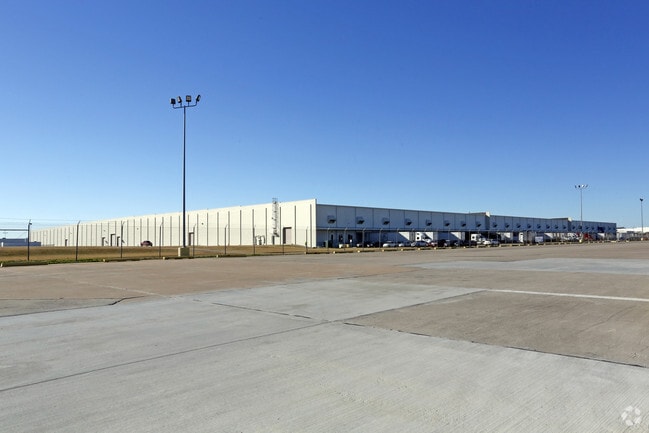

Property Detail
743 Henrietta Creek Rd
Dallas-Fort Worth-Arlington, TX
ALLIANCE GATEWAY-FOOD LION ADDN BLK 1 LOT 1 (PT) (DENTON CO PORTION)
R159978
Denton
Commercialnec
Texas
B and X Area of moderate flood hazard, usually the area between the limits of the 100-year and 500-year floods.
1
2024
49.19 AC
2025
NE Tarrant/Alliance
020312
Dallas/Ft Worth
1,330,394 SF
NEARBY LISTINGS FOR SALE OR LEASE
DEMOGRAPHICS near 743 Henrietta Creek Rd
1 mile
3 mile
5 mile
2024 Total Population
1,316
50,969
125,256
2029 Population
1,507
55,713
135,474
Pop Growth 2024-2029
+ 14.51%
+ 9.31%
+ 8.16%
Average Age
38
37
38
2024 Total Households
580
17,324
42,250
HH Growth 2024-2029
+ 14.66%
+ 9.83%
+ 8.49%
Median Household Inc
$108,073
$127,793
$131,326
Avg Household Size
2.20
2.90
2.90
2024 Avg HH Vehicles
2.00
2.00
2.00
Median Home Value
$590,909
$511,052
$494,599
Median Year Built
1995
2007
2006
Nearby Places
Map Layers
Map Styles
 Street
 Aerial
Transit
 Traffic
 Biking
Places
Listings with unknown addresses are not visible on the map
- Restaurants
- Banks
- Shops
- Fitness
- Groceries
PUBLIC TRANSPORTATION
AIRPORT
Dallas-Fort Worth International
Drive
Walk
Distance
Dallas-Fort Worth International
24 min
17.9 mi
Dallas Love Field
Drive
Walk
Distance
Dallas Love Field
43 min
31.6 mi
Freight Ports
Port of Shreveport
Drive
Walk
Distance
Port of Shreveport
252 min
231.5 mi
SALE & LEASE HISTORY
LISTING DATE
SALE/LEASE

Nov 29, 2023
For Lease
May 04, 2023
For Lease
Nearby Properties
Address
Land Use
TOTAL SIZE
Lot Size
Zoning
Address
Land Use
TOTAL SIZE
Lot Size
Zoning
1,542,470 SF
147.33 AC
Address
Land Use
TOTAL SIZE
Lot Size
Zoning
1,213,448 SF
59.10 AC
Address
Land Use
TOTAL SIZE
Lot Size
Zoning
1,315,600 SF
106.95 AC
Address
Land Use
TOTAL SIZE
Lot Size
Zoning
562,929 SF
15.89 AC
Address
Land Use
TOTAL SIZE
Lot Size
Zoning
311,224 SF
8.22 AC
Address
Land Use
TOTAL SIZE
Lot Size
Zoning
413,316 SF
22.96 AC
Address
Land Use
TOTAL SIZE
Lot Size
Zoning
471,408 SF
17.56 AC
Address
Land Use
TOTAL SIZE
Lot Size
Zoning
470,000 SF
11.91 AC
Address
Land Use
TOTAL SIZE
Lot Size
Zoning
495,170 SF
14.02 AC
Address
Land Use
TOTAL SIZE
Lot Size
Zoning
1,217,200 SF
56.35 AC
Address
Land Use
TOTAL SIZE
Lot Size
Zoning
455,935 SF
57.27 AC
Address
Land Use
TOTAL SIZE
Lot Size
Zoning
819,327 SF
143.07 AC
Address
Land Use
TOTAL SIZE
Lot Size
Zoning
442,788 SF
29.38 AC
Address
Land Use
TOTAL SIZE
Lot Size
Zoning
261,836 SF
33.32 AC
Address
Land Use
TOTAL SIZE
Lot Size
Zoning
261,836 SF
51.66 AC
Address
Land Use
TOTAL SIZE
Lot Size
Zoning
1,085,280 SF
68.36 AC
Address
Land Use
TOTAL SIZE
Lot Size
Zoning
1,111,500 SF
59.87 AC
Address
Land Use
TOTAL SIZE
Lot Size
Zoning
1,012,040 SF
58.69 AC
Address
Land Use
TOTAL SIZE
Lot Size
Zoning
301,718 SF
18.12 AC
10 G
Address
Land Use
TOTAL SIZE
Lot Size
Zoning
542,880 SF
28.13 AC
Address
Land Use
TOTAL SIZE
Lot Size
Zoning
1,010,969 SF
76.73 AC
Address
Land Use
TOTAL SIZE
Lot Size
Zoning
815,370 SF
41.27 AC
Address
Land Use
TOTAL SIZE
Lot Size
Zoning
783,000 SF
41.56 AC
Address
Land Use
TOTAL SIZE
Lot Size
Zoning
756,351 SF
33 AC
Address
Land Use
TOTAL SIZE
Lot Size
Zoning
291,475 SF
2.63 AC
Address
Land Use
TOTAL SIZE
Lot Size
Zoning
860,100 SF
40.02 AC
Address
Land Use
TOTAL SIZE
Lot Size
Zoning
756,351 SF
33 AC
Address
Land Use
TOTAL SIZE
Lot Size
Zoning
340,744 SF
13.85 AC
Address
Land Use
TOTAL SIZE
Lot Size
Zoning
667,152 SF
34.50 AC
Address
Land Use
TOTAL SIZE
Lot Size
Zoning
448,068 SF
34.33 AC
The World's #1 Commercial Real Estate Marketplace
Connect with us
© 2026 CoStar Group
The information above has been obtained from sources believed reliable. While we do not doubt its accuracy we have not verified it and make no guarantee, warranty or representation about it. It is your responsibility to independently confirm its accuracy and completeness. Any projections, opinions, assumptions, or estimates used are for example only and do not represent the current or future performance of the property. The value of this transaction to you depends on tax and other factors which should be evaluated by your tax, financial, and legal advisors. You and your advisors should conduct a careful, independent investigation of the property to determine to your satisfaction the suitability of the property for your needs.