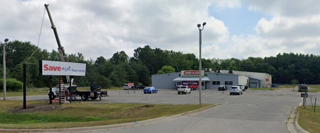
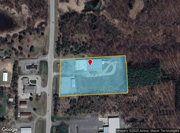
Property Record
7434 Storey Rd, Belding, MI 48809

NEARBY LISTINGS FOR SALE OR LEASE
-
-
View all Belding listings for sale on LoopNet.com
Property Detail
7434 Storey Rd
34-130-009-000-040-10
PT OF SE 1/4 SEC 9-8-8 OTISCO TWP COM N86?57?52?E 693.58 FT FROM COS; TH N86?57?52?E 625.01 FT, TH S03?02?44?E 66 FT, TH N
Commercialnec
Ionia
X
Michigan
26081C0375D
5.36 AC
2024
Ionia County
2025
West Michigan
030401
Grand Rapids-Wyoming-Kentwood, MI
29,586 SF
DEMOGRAPHICS near 7434 Storey Rd
1 Mile
3 Mile
5 Mile
2024 Total Population
1,515
8,200
12,124
2029 Population
1,543
8,396
12,468
Pop Growth 2024-2029
+ 1.85%
+ 2.39%
+ 2.84%
Average Age
41
40
41
2024 Total Households
647
3,165
4,635
HH Growth 2024-2029
+ 1.55%
+ 2.21%
+ 2.72%
Median Household Inc
$39,736
$53,885
$59,302
Avg Household Size
2.30
2.50
2.50
2024 Avg HH Vehicles
2.00
2.00
2.00
Median Home Value
$144,670
$141,024
$160,571
Median Year Built
1972
1959
1968
Nearby Places
Map Layers
Map Styles
 Street
 Aerial
- Restaurants
- Banks
- Shops
- Fitness
- Groceries
PUBLIC TRANSPORTATION
AIRPORT
Gerald R Ford International
DRIVE
WALK
Distance
Gerald R Ford International
49 min
33.3 mi
Freight Ports
Port of Toledo
DRIVE
WALK
Distance
Port of Toledo
218 min
181.5 mi
SALE & LEASE HISTORY
LISTING DATE
SALE/LEASE

Mar 09, 2021
For Sale
Nearby Properties
Address
Land Use
TOTAL SIZE
Lot Size
Zoning
Address
Land Use
TOTAL SIZE
Lot Size
Zoning
Address
Land Use
TOTAL SIZE
Lot Size
Zoning
168,870 SF
11.73 AC
Address
Land Use
TOTAL SIZE
Lot Size
Zoning
51.80 AC
I-1
Address
Land Use
TOTAL SIZE
Lot Size
Zoning
42,745 SF
3.05 AC
RM-1
Address
Land Use
TOTAL SIZE
Lot Size
Zoning
1,536 SF
4.11 AC
RM-1
Address
Land Use
TOTAL SIZE
Lot Size
Zoning
110,147 SF
7.97 AC
A-C
Address
Land Use
TOTAL SIZE
Lot Size
Zoning
3,164 SF
4.98 AC
RM-1
Address
Land Use
TOTAL SIZE
Lot Size
Zoning
37,200 SF
13.19 AC
B-2
Address
Land Use
TOTAL SIZE
Lot Size
Zoning
1,440 SF
10.24 AC
I-1
Address
Land Use
TOTAL SIZE
Lot Size
Zoning
16,632 SF
3.36 AC
R-3
Address
Land Use
TOTAL SIZE
Lot Size
Zoning
5,900 SF
11.51 AC
R-2
Address
Land Use
TOTAL SIZE
Lot Size
Zoning
17,988 SF
5.40 AC
RM-1
Address
Land Use
TOTAL SIZE
Lot Size
Zoning
33.38 AC
RM-2
Address
Land Use
TOTAL SIZE
Lot Size
Zoning
25,682 SF
218.66 AC
R-1
Address
Land Use
TOTAL SIZE
Lot Size
Zoning
149,250 SF
6.76 AC
I-1
Address
Land Use
TOTAL SIZE
Lot Size
Zoning
12,164 SF
4.42 AC
RM-1
Address
Land Use
TOTAL SIZE
Lot Size
Zoning
64,608 SF
2.25 AC
Address
Land Use
TOTAL SIZE
Lot Size
Zoning
75,689 SF
9.46 AC
I-1
Address
Land Use
TOTAL SIZE
Lot Size
Zoning
17,290 SF
1.11 AC
B-1
Address
Land Use
TOTAL SIZE
Lot Size
Zoning
11,048 SF
3.66 AC
RM-1
Address
Land Use
TOTAL SIZE
Lot Size
Zoning
68,627 SF
11.90 AC
A-C
Address
Land Use
TOTAL SIZE
Lot Size
Zoning
7,440 SF
16.74 AC
B-2
Address
Land Use
TOTAL SIZE
Lot Size
Zoning
58,695 SF
3.13 AC
I-1
Address
Land Use
TOTAL SIZE
Lot Size
Zoning
1,689 SF
41.09 AC
A1
Address
Land Use
TOTAL SIZE
Lot Size
Zoning
382.58 AC
Address
Land Use
TOTAL SIZE
Lot Size
Zoning
Address
Land Use
TOTAL SIZE
Lot Size
Zoning
2,765 SF
105 AC
A-C
Address
Land Use
TOTAL SIZE
Lot Size
Zoning
127.59 AC
Address
Land Use
TOTAL SIZE
Lot Size
Zoning
2,457 SF
84 AC
R-C
Address
Land Use
TOTAL SIZE
Lot Size
Zoning
5,176 SF
2.43 AC
RM-1
The World's #1 Commercial Real Estate Marketplace
Connect with us
© 2026 CoStar Group
The information above has been obtained from sources believed reliable. While we do not doubt its accuracy we have not verified it and make no guarantee, warranty or representation about it. It is your responsibility to independently confirm its accuracy and completeness. Any projections, opinions, assumptions, or estimates used are for example only and do not represent the current or future performance of the property. The value of this transaction to you depends on tax and other factors which should be evaluated by your tax, financial, and legal advisors. You and your advisors should conduct a careful, independent investigation of the property to determine to your satisfaction the suitability of the property for your needs.