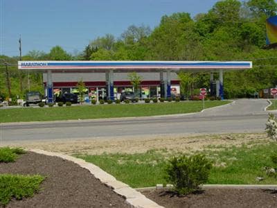
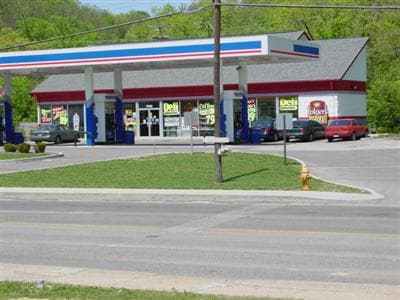
Property Record
7436 Wooster Pike, Cincinnati, OH 45227
NEARBY LISTINGS FOR SALE OR LEASE
Property Detail
7436 Wooster Pike
520-0111-0080
NS WOOSTER PK 0.1005 AC R2-T4-S3 SW PARS 78- 79 CONS
Servicestationmarket
Hamilton
AE
Ohio
39061C0263F
0.70 AC
2024
Milford/Wards Corner
2024
Cincinnati/Dayton
024401
Cincinnati, OH-KY-IN
2,052 SF
DEMOGRAPHICS near 7436 Wooster Pike
1 Mile
3 Mile
5 Mile
2024 Total Population
3,616
36,167
158,179
2029 Population
3,597
35,934
156,863
Pop Growth 2024-2029
(0.53%)
(0.64%)
(0.83%)
Average Age
42
41
40
2024 Total Households
1,410
15,140
69,398
HH Growth 2024-2029
(0.50%)
(0.54%)
(0.89%)
Median Household Inc
$124,404
$91,115
$84,633
Avg Household Size
2.50
2.30
2.20
2024 Avg HH Vehicles
2.00
2.00
2.00
Median Home Value
$491,548
$350,379
$283,014
Median Year Built
1952
1959
1959
Nearby Places
Map Layers
Map Styles
 Street
 Aerial
- Restaurants
- Banks
- Shops
- Fitness
- Groceries
PUBLIC TRANSPORTATION
AIRPORT
Cincinnati/Northern Kentucky International
DRIVE
WALK
Distance
Cincinnati/Northern Kentucky International
44 min
24.6 mi
Freight Ports
Port of Toledo
DRIVE
WALK
Distance
Port of Toledo
246 min
207.4 mi
Nearby Properties
Address
Land Use
TOTAL SIZE
Lot Size
Zoning
Address
Land Use
TOTAL SIZE
Lot Size
Zoning
9.16 AC
Address
Land Use
TOTAL SIZE
Lot Size
Zoning
Address
Land Use
TOTAL SIZE
Lot Size
Zoning
5.07 AC
Address
Land Use
TOTAL SIZE
Lot Size
Zoning
0.26 AC
RM12
Address
Land Use
TOTAL SIZE
Lot Size
Zoning
6.91 AC
Address
Land Use
TOTAL SIZE
Lot Size
Zoning
4,706 SF
18.29 AC
RM20
Address
Land Use
TOTAL SIZE
Lot Size
Zoning
7.06 AC
Address
Land Use
TOTAL SIZE
Lot Size
Zoning
1,152 SF
24.78 AC
B
Address
Land Use
TOTAL SIZE
Lot Size
Zoning
20.01 AC
Address
Land Use
TOTAL SIZE
Lot Size
Zoning
1,205 SF
41.47 AC
Address
Land Use
TOTAL SIZE
Lot Size
Zoning
25.51 AC
Address
Land Use
TOTAL SIZE
Lot Size
Zoning
1.77 AC
Address
Land Use
TOTAL SIZE
Lot Size
Zoning
20.38 AC
Address
Land Use
TOTAL SIZE
Lot Size
Zoning
49.27 AC
Address
Land Use
TOTAL SIZE
Lot Size
Zoning
8.99 AC
Address
Land Use
TOTAL SIZE
Lot Size
Zoning
3.53 AC
PD
Address
Land Use
TOTAL SIZE
Lot Size
Zoning
19.33 AC
OG
Address
Land Use
TOTAL SIZE
Lot Size
Zoning
1,072,127 SF
229.73 AC
Address
Land Use
TOTAL SIZE
Lot Size
Zoning
1.90 AC
Address
Land Use
TOTAL SIZE
Lot Size
Zoning
1.94 AC
Address
Land Use
TOTAL SIZE
Lot Size
Zoning
28.27 AC
Address
Land Use
TOTAL SIZE
Lot Size
Zoning
34.46 AC
MG
Address
Land Use
TOTAL SIZE
Lot Size
Zoning
7.49 AC
Address
Land Use
TOTAL SIZE
Lot Size
Zoning
8.64 AC
Address
Land Use
TOTAL SIZE
Lot Size
Zoning
6.55 AC
Address
Land Use
TOTAL SIZE
Lot Size
Zoning
55,848 SF
12.51 AC
Address
Land Use
TOTAL SIZE
Lot Size
Zoning
3,508 SF
9.10 AC
RM12
Address
Land Use
TOTAL SIZE
Lot Size
Zoning
16.40 AC
Address
Land Use
TOTAL SIZE
Lot Size
Zoning
6.77 AC
PD
Address
Land Use
TOTAL SIZE
Lot Size
Zoning
49.66 AC
The World's #1 Commercial Real Estate Marketplace
Connect with us
© 2025 CoStar Group
The information above has been obtained from sources believed reliable. While we do not doubt its accuracy we have not verified it and make no guarantee, warranty or representation about it. It is your responsibility to independently confirm its accuracy and completeness. Any projections, opinions, assumptions, or estimates used are for example only and do not represent the current or future performance of the property. The value of this transaction to you depends on tax and other factors which should be evaluated by your tax, financial, and legal advisors. You and your advisors should conduct a careful, independent investigation of the property to determine to your satisfaction the suitability of the property for your needs.