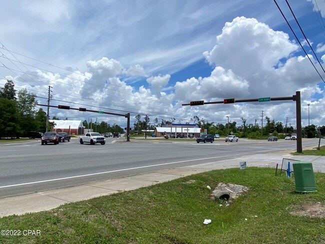
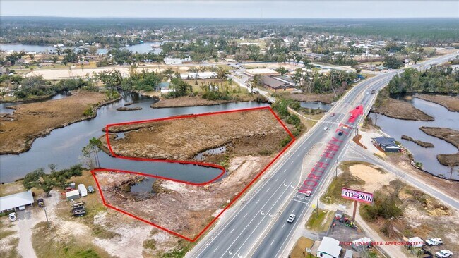
Property Record
27 2S, Southport, FL 32409
Current Lease Availabilities
NEARBY LISTINGS FOR SALE OR LEASE
Property Detail
27 2S
07994-010-000
27 2S 14W-58-101A2 BEG 405 W OF SE COR OF SE1/4 OF SW1/4 OF NW1/4 TH N 75.75 NELY 71.8 NWLY 127.7 SWLY 247.6 S 125 E 255 TO POB LESS PSL ON W. END & SBJ TO ESMT IN ORB 1217 P 646 ORB 4468 P 1498 LESS HWY 77 R/W DOT PRCL# 104
Vacantlandnec
Bay
AE
Florida
12005C0220J
1.22 AC
2023
Panama City
2024
Other Market Areas
000203
Panama City, FL
DEMOGRAPHICS near 27 2S
1 Mile
3 Mile
5 Mile
2024 Total Population
1,764
9,751
31,059
2029 Population
2,301
12,452
39,000
Pop Growth 2024-2029
+ 30.44%
+ 27.70%
+ 25.57%
Average Age
40
42
41
2024 Total Households
653
3,613
11,717
HH Growth 2024-2029
+ 31.55%
+ 28.70%
+ 26.50%
Median Household Inc
$52,734
$76,155
$84,476
Avg Household Size
2.70
2.60
2.60
2024 Avg HH Vehicles
2.00
2.00
2.00
Median Home Value
$353,539
$341,707
$336,519
Median Year Built
1996
1992
1992
Nearby Places
Map Layers
Map Styles
 Street
 Aerial
- Restaurants
- Banks
- Shops
- Fitness
- Groceries
PUBLIC TRANSPORTATION
AIRPORT
Northwest Florida Beaches International
DRIVE
WALK
Distance
Northwest Florida Beaches International
20 min
13.7 mi
Freight Ports
Port of Panama City
DRIVE
WALK
Distance
Port of Panama City
22 min
10.8 mi
Nearby Properties
Address
Land Use
TOTAL SIZE
Lot Size
Zoning
Address
Land Use
TOTAL SIZE
Lot Size
Zoning
50,491 SF
6.48 AC
BC14
Address
Land Use
TOTAL SIZE
Lot Size
Zoning
241.76 AC
BC01
Address
Land Use
TOTAL SIZE
Lot Size
Zoning
42,809 SF
0.77 AC
PSP
Address
Land Use
TOTAL SIZE
Lot Size
Zoning
27,485 SF
1.76 AC
BC16
Address
Land Use
TOTAL SIZE
Lot Size
Zoning
2,895 SF
97.83 AC
Address
Land Use
TOTAL SIZE
Lot Size
Zoning
69,020 SF
4.44 AC
BC14
Address
Land Use
TOTAL SIZE
Lot Size
Zoning
16,165 SF
1.72 AC
RB
Address
Land Use
TOTAL SIZE
Lot Size
Zoning
73,792 SF
7.53 AC
PSP
Address
Land Use
TOTAL SIZE
Lot Size
Zoning
24,134 SF
5.17 AC
UND
Address
Land Use
TOTAL SIZE
Lot Size
Zoning
57,580 SF
4.01 AC
BC05
Address
Land Use
TOTAL SIZE
Lot Size
Zoning
6.65 AC
BC13
Address
Land Use
TOTAL SIZE
Lot Size
Zoning
231.05 AC
BC08
Address
Land Use
TOTAL SIZE
Lot Size
Zoning
31 AC
BC16
Address
Land Use
TOTAL SIZE
Lot Size
Zoning
16,929 SF
4.06 AC
BC14
Address
Land Use
TOTAL SIZE
Lot Size
Zoning
24,484 SF
3.44 AC
PSP
Address
Land Use
TOTAL SIZE
Lot Size
Zoning
12,060 SF
50.03 AC
BC14
Address
Land Use
TOTAL SIZE
Lot Size
Zoning
10,960 SF
6.61 AC
BC05
Address
Land Use
TOTAL SIZE
Lot Size
Zoning
110.28 AC
BC08
Address
Land Use
TOTAL SIZE
Lot Size
Zoning
16,815 SF
5.48 AC
BC05
Address
Land Use
TOTAL SIZE
Lot Size
Zoning
29,009 SF
3.43 AC
BC05
Address
Land Use
TOTAL SIZE
Lot Size
Zoning
1,380 SF
270.44 AC
BC02
Address
Land Use
TOTAL SIZE
Lot Size
Zoning
975 SF
3.44 AC
PSP
Address
Land Use
TOTAL SIZE
Lot Size
Zoning
36.70 AC
BC08
Address
Land Use
TOTAL SIZE
Lot Size
Zoning
6,640 SF
0.54 AC
RB
Address
Land Use
TOTAL SIZE
Lot Size
Zoning
14,108 SF
0.62 AC
PSP
Address
Land Use
TOTAL SIZE
Lot Size
Zoning
110.25 AC
BC16
Address
Land Use
TOTAL SIZE
Lot Size
Zoning
9,956 SF
13 AC
BC14
Address
Land Use
TOTAL SIZE
Lot Size
Zoning
8,100 SF
2.24 AC
RB
Address
Land Use
TOTAL SIZE
Lot Size
Zoning
5,317 SF
1.08 AC
RB
Address
Land Use
TOTAL SIZE
Lot Size
Zoning
12,838 SF
2.62 AC
BC14
The World's #1 Commercial Real Estate Marketplace
Connect with us
© 2026 CoStar Group
The information above has been obtained from sources believed reliable. While we do not doubt its accuracy we have not verified it and make no guarantee, warranty or representation about it. It is your responsibility to independently confirm its accuracy and completeness. Any projections, opinions, assumptions, or estimates used are for example only and do not represent the current or future performance of the property. The value of this transaction to you depends on tax and other factors which should be evaluated by your tax, financial, and legal advisors. You and your advisors should conduct a careful, independent investigation of the property to determine to your satisfaction the suitability of the property for your needs.