Property Record
7437 Highway 85, Riverdale, GA 30274
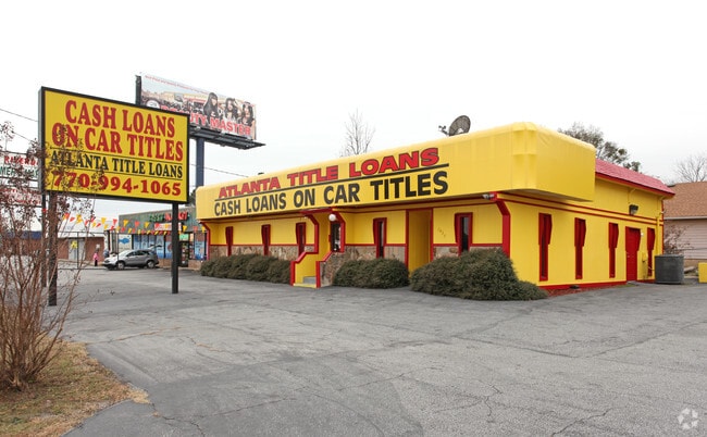


This Property Is For Sale
NEARBY LISTINGS FOR SALE OR LEASE
Property Detail
7437 Highway 85
13-0183C-00D-005
Clayton
Officebuilding
Georgia
X
4
13063C0066F
0.14 AC
2024
Riverdale/Jonesboro
2024
Atlanta
040513
Atlanta-Sandy Springs-Roswell, GA
2,388 SF
DEMOGRAPHICS near 7437 Highway 85
1 Mile
3 Mile
5 Mile
2024 Total Population
7,787
82,195
183,475
2029 Population
7,726
81,941
184,049
Pop Growth 2024-2029
(0.78%)
(0.31%)
+ 0.31%
Average Age
37
36
36
2024 Total Households
2,817
29,914
66,975
HH Growth 2024-2029
(0.75%)
(0.31%)
+ 0.28%
Median Household Inc
$49,096
$49,301
$50,339
Avg Household Size
2.70
2.70
2.70
2024 Avg HH Vehicles
2.00
2.00
2.00
Median Home Value
$168,094
$162,370
$167,891
Median Year Built
1990
1984
1984
Nearby Places
- Restaurants
- Banks
- Shops
- Fitness
- Groceries
PUBLIC TRANSPORTATION
AIRPORT
Hartsfield - Jackson Atlanta International
DRIVE
WALK
Distance
Hartsfield - Jackson Atlanta International
16 min
8.2 mi
Nearby Properties
Address
Land Use
TOTAL SIZE
Lot Size
Zoning
Address
Land Use
TOTAL SIZE
Lot Size
Zoning
518,648 SF
58.27 AC
MCD
Address
Land Use
TOTAL SIZE
Lot Size
Zoning
324 SF
49.49 AC
RM
Address
Land Use
TOTAL SIZE
Lot Size
Zoning
196 SF
19.90 AC
C
Address
Land Use
TOTAL SIZE
Lot Size
Zoning
40,472 SF
116.70 AC
HI
Address
Land Use
TOTAL SIZE
Lot Size
Zoning
294 SF
21.17 AC
PUD
Address
Land Use
TOTAL SIZE
Lot Size
Zoning
240 SF
26.94 AC
RM
Address
Land Use
TOTAL SIZE
Lot Size
Zoning
216 SF
24.45 AC
RM
Address
Land Use
TOTAL SIZE
Lot Size
Zoning
316 SF
34.30 AC
RG75
Address
Land Use
TOTAL SIZE
Lot Size
Zoning
198 SF
32.10 AC
RM
Address
Land Use
TOTAL SIZE
Lot Size
Zoning
424 SF
54.79 AC
RM
Address
Land Use
TOTAL SIZE
Lot Size
Zoning
296 SF
27.93 AC
RM
Address
Land Use
TOTAL SIZE
Lot Size
Zoning
190 SF
21.66 AC
RM
Address
Land Use
TOTAL SIZE
Lot Size
Zoning
270 SF
28.02 AC
RM
Address
Land Use
TOTAL SIZE
Lot Size
Zoning
370 SF
36.20 AC
RM
Address
Land Use
TOTAL SIZE
Lot Size
Zoning
278 SF
18.53 AC
PUD
Address
Land Use
TOTAL SIZE
Lot Size
Zoning
123,000 SF
48 AC
RS110
Address
Land Use
TOTAL SIZE
Lot Size
Zoning
256 SF
25 AC
PUD
Address
Land Use
TOTAL SIZE
Lot Size
Zoning
218 SF
17.30 AC
RM
Address
Land Use
TOTAL SIZE
Lot Size
Zoning
220 SF
26.84 AC
RM
Address
Land Use
TOTAL SIZE
Lot Size
Zoning
410 SF
35 AC
RM
Address
Land Use
TOTAL SIZE
Lot Size
Zoning
57.05 AC
GB
Address
Land Use
TOTAL SIZE
Lot Size
Zoning
160 SF
19.95 AC
RM
Address
Land Use
TOTAL SIZE
Lot Size
Zoning
11.88 AC
RM
Address
Land Use
TOTAL SIZE
Lot Size
Zoning
147,540 SF
47.10 AC
C RP
Address
Land Use
TOTAL SIZE
Lot Size
Zoning
230 SF
21.20 AC
RM
Address
Land Use
TOTAL SIZE
Lot Size
Zoning
168 SF
17.28 AC
RM
Address
Land Use
TOTAL SIZE
Lot Size
Zoning
481 SF
90.43 AC
RMH
Address
Land Use
TOTAL SIZE
Lot Size
Zoning
216 SF
22.12 AC
RM
Address
Land Use
TOTAL SIZE
Lot Size
Zoning
252 SF
27.14 AC
RM
Address
Land Use
TOTAL SIZE
Lot Size
Zoning
224 SF
25 AC
C
The World's #1 Commercial Real Estate Marketplace
Connect with us
© 2025 CoStar Group
The information above has been obtained from sources believed reliable. While we do not doubt its accuracy we have not verified it and make no guarantee, warranty or representation about it. It is your responsibility to independently confirm its accuracy and completeness. Any projections, opinions, assumptions, or estimates used are for example only and do not represent the current or future performance of the property. The value of this transaction to you depends on tax and other factors which should be evaluated by your tax, financial, and legal advisors. You and your advisors should conduct a careful, independent investigation of the property to determine to your satisfaction the suitability of the property for your needs.