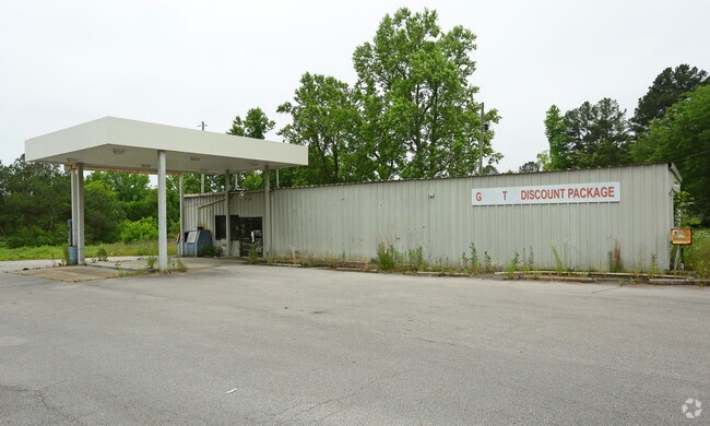
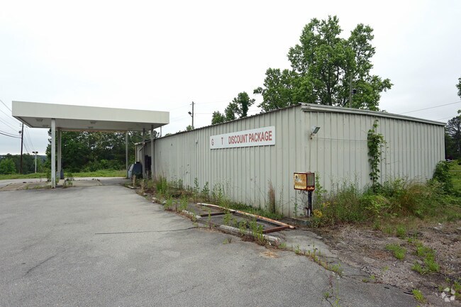
Property Record
7438 Highway 78, Dora, AL 35062

Property Detail
7438 Highway 78
05-00-24-0-000-005.002
COM NW COR OF NE 1/4 SEC 24 TP 15 R 5W TH E 410 FT TO SW ROW OF HWY 78 TH SE ALG ROW 560 FT TO POB CONT SE 510 FT TH W 555 FT TH NE 287.6 FT TO POB
Servicestation
Jefferson
C1-A
Alabama
B and X Area of moderate flood hazard, usually the area between the limits of the 100-year and 500-year floods.
3 AC
2024
Bessemer
2025
Birmingham
011500
Birmingham, AL
2,460 SF
NEARBY LISTINGS FOR SALE OR LEASE
-
-
View all Dora listings for sale on LoopNet.com
DEMOGRAPHICS near 7438 Highway 78
1 mile
3 mile
5 mile
2025 Total Population
1,010
6,416
12,415
2030 Population
1,025
6,489
12,547
Pop Growth 2025-2030
+ 1.49%
+ 1.14%
+ 1.06%
Average Age
42
42
42
2025 Total Households
392
2,512
4,873
HH Growth 2025-2030
+ 1.53%
+ 1.15%
+ 1.09%
Median Household Inc
$66,066
$69,181
$69,645
Avg Household Size
2.50
2.50
2.50
2025 Avg HH Vehicles
3.00
2.00
2.00
Median Home Value
$206,626
$204,439
$184,258
Median Year Built
1982
1979
1980
Nearby Places
Map Layers
Map Styles
 Street
 Aerial
Layers
 Traffic
 Biking
Places
Listings with unknown addresses are not visible on the map
- Restaurants
- Banks
- Shops
- Fitness
- Groceries
PUBLIC TRANSPORTATION
AIRPORT
Birmingham-Shuttlesworth International
Drive
Walk
Distance
Birmingham-Shuttlesworth International
35 min
28.0 mi
Nearby Properties
Address
Land Use
TOTAL SIZE
Lot Size
Zoning
Address
Land Use
TOTAL SIZE
Lot Size
Zoning
14,504 SF
1.40 AC
SF
Address
Land Use
TOTAL SIZE
Lot Size
Zoning
23,730 SF
1 AC
INST
Address
Land Use
TOTAL SIZE
Lot Size
Zoning
855 SF
157 AC
CO
Address
Land Use
TOTAL SIZE
Lot Size
Zoning
6,880 SF
3.10 AC
O
Address
Land Use
TOTAL SIZE
Lot Size
Zoning
13,844 SF
2 AC
CEM
Address
Land Use
TOTAL SIZE
Lot Size
Zoning
14,860 SF
1 AC
A1
Address
Land Use
TOTAL SIZE
Lot Size
Zoning
13,996 SF
2 AC
INST
Address
Land Use
TOTAL SIZE
Lot Size
Zoning
30,000 SF
3 AC
C1
Address
Land Use
TOTAL SIZE
Lot Size
Zoning
3,180 SF
3.31 AC
CO
Address
Land Use
TOTAL SIZE
Lot Size
Zoning
3,220 SF
2 AC
C1-C
Address
Land Use
TOTAL SIZE
Lot Size
Zoning
10,290 SF
1.77 AC
O
Address
Land Use
TOTAL SIZE
Lot Size
Zoning
4,789 SF
2 AC
C3
Address
Land Use
TOTAL SIZE
Lot Size
Zoning
6,865 SF
0.70 AC
CO
Address
Land Use
TOTAL SIZE
Lot Size
Zoning
8,763 SF
2 AC
A1
Address
Land Use
TOTAL SIZE
Lot Size
Zoning
3,636 SF
1.40 AC
SF
Address
Land Use
TOTAL SIZE
Lot Size
Zoning
6,982 SF
8 AC
A1
Address
Land Use
TOTAL SIZE
Lot Size
Zoning
7,118 SF
0.35 AC
I &
Address
Land Use
TOTAL SIZE
Lot Size
Zoning
5,760 SF
0.50 AC
S
Address
Land Use
TOTAL SIZE
Lot Size
Zoning
1,456 SF
0.90 AC
O
Address
Land Use
TOTAL SIZE
Lot Size
Zoning
624 SF
3.40 AC
CO
Address
Land Use
TOTAL SIZE
Lot Size
Zoning
2,275 SF
0.80 AC
O
Address
Land Use
TOTAL SIZE
Lot Size
Zoning
11,250 SF
3.10 AC
OT
Address
Land Use
TOTAL SIZE
Lot Size
Zoning
584 SF
36 AC
CO
Address
Land Use
TOTAL SIZE
Lot Size
Zoning
2,600 SF
2.50 AC
OT
Address
Land Use
TOTAL SIZE
Lot Size
Zoning
5,800 SF
2.90 AC
O
The World's #1 Commercial Real Estate Marketplace
Connect with us
© 2026 CoStar Group
The information above has been obtained from sources believed reliable. While we do not doubt its accuracy we have not verified it and make no guarantee, warranty or representation about it. It is your responsibility to independently confirm its accuracy and completeness. Any projections, opinions, assumptions, or estimates used are for example only and do not represent the current or future performance of the property. The value of this transaction to you depends on tax and other factors which should be evaluated by your tax, financial, and legal advisors. You and your advisors should conduct a careful, independent investigation of the property to determine to your satisfaction the suitability of the property for your needs.