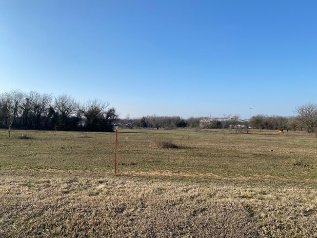
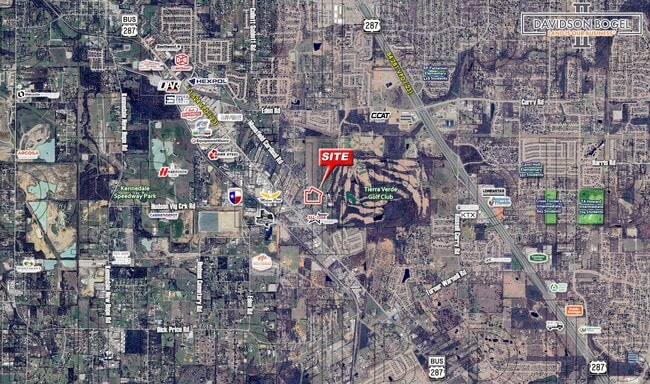
Property Record
7440 Mansfield Cardinal Rd, Kennedale, TX 76060
NEARBY LISTINGS FOR SALE OR LEASE
Property Detail
7440 Mansfield Cardinal Rd
Dallas/Ft Worth
Wilson, Joseph E Survey
Dallas-Fort Worth-Arlington, TX
Tarrant
04262603
Texas
Residentialacreage
7.95 AC
X
Arlington/Mansfield
48251C0100J
DEMOGRAPHICS near 7440 Mansfield Cardinal Rd
1 Mile
3 Mile
5 Mile
2024 Total Population
2,135
51,641
176,747
2029 Population
2,305
54,581
186,001
Pop Growth 2024-2029
+ 7.96%
+ 5.69%
+ 5.24%
Average Age
40
40
39
2024 Total Households
742
18,208
61,435
HH Growth 2024-2029
+ 7.95%
+ 5.72%
+ 5.28%
Median Household Inc
$89,166
$96,350
$85,650
Avg Household Size
2.80
2.80
2.80
2024 Avg HH Vehicles
2.00
2.00
2.00
Median Home Value
$356,578
$321,237
$281,179
Median Year Built
2006
1994
1991
Nearby Places
Map Layers
Map Styles
 Street
 Aerial
- Restaurants
- Banks
- Shops
- Fitness
- Groceries
PUBLIC TRANSPORTATION
AIRPORT
Dallas-Fort Worth International
DRIVE
WALK
Distance
Dallas-Fort Worth International
43 min
31.4 mi
Dallas Love Field
DRIVE
WALK
Distance
Dallas Love Field
53 min
38.7 mi
Freight Ports
Port of Shreveport
DRIVE
WALK
Distance
Port of Shreveport
244 min
224.4 mi
SALE & LEASE HISTORY
LISTING DATE
SALE/LEASE

Jul 20, 2021
For Sale
Apr 16, 2025
For Sale
Nearby Properties
Address
Land Use
TOTAL SIZE
Lot Size
Zoning
Address
Land Use
TOTAL SIZE
Lot Size
Zoning
160,000 SF
26.90 AC
Address
Land Use
TOTAL SIZE
Lot Size
Zoning
170,082 SF
36.49 AC
Address
Land Use
TOTAL SIZE
Lot Size
Zoning
214,444 SF
17.45 AC
Address
Land Use
TOTAL SIZE
Lot Size
Zoning
167,643 SF
8.99 AC
Address
Land Use
TOTAL SIZE
Lot Size
Zoning
169,347 SF
13.92 AC
Address
Land Use
TOTAL SIZE
Lot Size
Zoning
222,500 SF
13.86 AC
Address
Land Use
TOTAL SIZE
Lot Size
Zoning
301,302 SF
0.46 AC
Address
Land Use
TOTAL SIZE
Lot Size
Zoning
79,070 SF
11.98 AC
Address
Land Use
TOTAL SIZE
Lot Size
Zoning
217,786 SF
39.04 AC
Address
Land Use
TOTAL SIZE
Lot Size
Zoning
268,603 SF
12.45 AC
Address
Land Use
TOTAL SIZE
Lot Size
Zoning
238,119 SF
7.52 AC
Address
Land Use
TOTAL SIZE
Lot Size
Zoning
119,741 SF
45 AC
Address
Land Use
TOTAL SIZE
Lot Size
Zoning
81,540 SF
11.89 AC
Address
Land Use
TOTAL SIZE
Lot Size
Zoning
80,907 SF
29 AC
Address
Land Use
TOTAL SIZE
Lot Size
Zoning
44,669 SF
9.05 AC
Address
Land Use
TOTAL SIZE
Lot Size
Zoning
143,104 SF
7.75 AC
Address
Land Use
TOTAL SIZE
Lot Size
Zoning
77,884 SF
30.70 AC
Address
Land Use
TOTAL SIZE
Lot Size
Zoning
127,690 SF
37.21 AC
Address
Land Use
TOTAL SIZE
Lot Size
Zoning
156,103 SF
4.42 AC
Address
Land Use
TOTAL SIZE
Lot Size
Zoning
41,960 SF
13.70 AC
Address
Land Use
TOTAL SIZE
Lot Size
Zoning
110,621 SF
12.27 AC
Address
Land Use
TOTAL SIZE
Lot Size
Zoning
108,708 SF
16.64 AC
Address
Land Use
TOTAL SIZE
Lot Size
Zoning
112,110 SF
14.64 AC
Address
Land Use
TOTAL SIZE
Lot Size
Zoning
79,380 SF
12.90 AC
Address
Land Use
TOTAL SIZE
Lot Size
Zoning
121,438 SF
5.89 AC
Address
Land Use
TOTAL SIZE
Lot Size
Zoning
38,400 SF
43.84 AC
Address
Land Use
TOTAL SIZE
Lot Size
Zoning
50,000 SF
17.96 AC
Address
Land Use
TOTAL SIZE
Lot Size
Zoning
36,093 SF
3.98 AC
Address
Land Use
TOTAL SIZE
Lot Size
Zoning
73,145 SF
9.97 AC
Address
Land Use
TOTAL SIZE
Lot Size
Zoning
11,388 SF
232.89 AC
The World's #1 Commercial Real Estate Marketplace
Connect with us
© 2025 CoStar Group
The information above has been obtained from sources believed reliable. While we do not doubt its accuracy we have not verified it and make no guarantee, warranty or representation about it. It is your responsibility to independently confirm its accuracy and completeness. Any projections, opinions, assumptions, or estimates used are for example only and do not represent the current or future performance of the property. The value of this transaction to you depends on tax and other factors which should be evaluated by your tax, financial, and legal advisors. You and your advisors should conduct a careful, independent investigation of the property to determine to your satisfaction the suitability of the property for your needs.