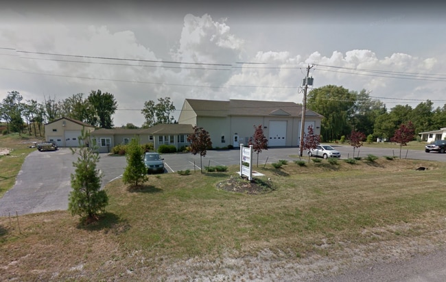
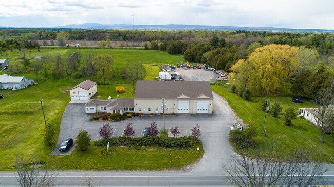
Property Record
7441 State Route 9, Plattsburgh, NY 12901

Property Detail
7441 State Route 9
094200-181-000-0003-002-000-0000
10 PAT CHP STATE RD EASEMENT BK 1021 PG 196
Commercialofficeresidentialmixeduse
Clinton
C
New York
B and X Area of moderate flood hazard, usually the area between the limits of the 100-year and 500-year floods.
2.000
2025
7.06 AC
2025
Plattsburgh
100800
Other Market Areas
6,794 SF
Plattsburgh, NY
NEARBY LISTINGS FOR SALE OR LEASE
DEMOGRAPHICS near 7441 State Route 9
1 mile
3 mile
5 mile
2025 Total Population
388
4,277
23,611
2030 Population
386
4,262
23,330
Pop Growth 2025-2030
(0.52%)
(0.35%)
(1.19%)
Average Age
44
44
42
2025 Total Households
163
1,943
11,112
HH Growth 2025-2030
(0.61%)
(0.41%)
(1.23%)
Median Household Inc
$87,500
$86,394
$56,172
Avg Household Size
2.20
2.10
2.00
2025 Avg HH Vehicles
2.00
2.00
2.00
Median Home Value
$282,758
$224,912
$201,770
Median Year Built
1968
1968
1967
Nearby Places
Map Layers
Map Styles
 Street
 Aerial
Layers
 Traffic
 Biking
Places
Listings with unknown addresses are not visible on the map
- Restaurants
- Banks
- Shops
- Fitness
- Groceries
PUBLIC TRANSPORTATION
COMMUTER RAIL
Plattsburgh Amtrak Station (Adirondack - Amtrak)
Drive
Walk
Distance
Plattsburgh Amtrak Station (Adirondack - Amtrak)
7 min
4.2 mi
AIRPORT
Plattsburgh International
Drive
Walk
Distance
Plattsburgh International
12 min
7.0 mi
Patrick Leahy Burlington International
Drive
Walk
Distance
Patrick Leahy Burlington International
65 min
30.2 mi
Freight Ports
Montreal
Drive
Walk
Distance
Montreal
82 min
61.8 mi
SALE & LEASE HISTORY
LISTING DATE
SALE/LEASE

Oct 20, 2023
For Sale
May 19, 2021
For Sale
Jul 14, 2020
For Sale
Nearby Properties
Address
Land Use
TOTAL SIZE
Lot Size
Zoning
Address
Land Use
TOTAL SIZE
Lot Size
Zoning
88,880 SF
5.73 AC
I
Address
Land Use
TOTAL SIZE
Lot Size
Zoning
112,400 SF
13.20 AC
I
Address
Land Use
TOTAL SIZE
Lot Size
Zoning
965,099 SF
113.70 AC
06 - INDUS
Address
Land Use
TOTAL SIZE
Lot Size
Zoning
64,993 SF
15 AC
R-4
Address
Land Use
TOTAL SIZE
Lot Size
Zoning
74,184 SF
2.80 AC
07 - MIXED
Address
Land Use
TOTAL SIZE
Lot Size
Zoning
45.50 AC
LC_OS
Address
Land Use
TOTAL SIZE
Lot Size
Zoning
7,488 SF
2.39 AC
07 - MIXED
Address
Land Use
TOTAL SIZE
Lot Size
Zoning
74,904 SF
16 AC
06 - INDUS
Address
Land Use
TOTAL SIZE
Lot Size
Zoning
30,964 SF
7.36 AC
Address
Land Use
TOTAL SIZE
Lot Size
Zoning
35,152 SF
7.05 AC
SC
Address
Land Use
TOTAL SIZE
Lot Size
Zoning
112,971 SF
19.62 AC
SC
Address
Land Use
TOTAL SIZE
Lot Size
Zoning
40,441 SF
7.04 AC
SC
Address
Land Use
TOTAL SIZE
Lot Size
Zoning
4,623 SF
93 AC
07 - MIXED
Address
Land Use
TOTAL SIZE
Lot Size
Zoning
3,968 SF
156.60 AC
Address
Land Use
TOTAL SIZE
Lot Size
Zoning
17,262 SF
1.30 AC
05 - COMME
Address
Land Use
TOTAL SIZE
Lot Size
Zoning
12.65 AC
07 - MIXED
Address
Land Use
TOTAL SIZE
Lot Size
Zoning
2.60 AC
Address
Land Use
TOTAL SIZE
Lot Size
Zoning
6,258 SF
5.40 AC
C
Address
Land Use
TOTAL SIZE
Lot Size
Zoning
31,858 SF
2.60 AC
C
Address
Land Use
TOTAL SIZE
Lot Size
Zoning
8,280 SF
0.77 AC
05 - COMME
Address
Land Use
TOTAL SIZE
Lot Size
Zoning
42,444 SF
2.19 AC
05 - COMME
Address
Land Use
TOTAL SIZE
Lot Size
Zoning
9 AC
03 - MULTI
Address
Land Use
TOTAL SIZE
Lot Size
Zoning
59,800 SF
3.42 AC
Address
Land Use
TOTAL SIZE
Lot Size
Zoning
5,001 SF
1.99 AC
R-4
Address
Land Use
TOTAL SIZE
Lot Size
Zoning
6,846 SF
74.90 AC
I
Address
Land Use
TOTAL SIZE
Lot Size
Zoning
11,631 SF
1.49 AC
06 - INDUS
Address
Land Use
TOTAL SIZE
Lot Size
Zoning
10,800 SF
3.10 AC
I
Address
Land Use
TOTAL SIZE
Lot Size
Zoning
1.10 AC
I
Address
Land Use
TOTAL SIZE
Lot Size
Zoning
4.14 AC
10
Address
Land Use
TOTAL SIZE
Lot Size
Zoning
270.40 AC
R-4
The World's #1 Commercial Real Estate Marketplace
Connect with us
© 2026 CoStar Group
The information above has been obtained from sources believed reliable. While we do not doubt its accuracy we have not verified it and make no guarantee, warranty or representation about it. It is your responsibility to independently confirm its accuracy and completeness. Any projections, opinions, assumptions, or estimates used are for example only and do not represent the current or future performance of the property. The value of this transaction to you depends on tax and other factors which should be evaluated by your tax, financial, and legal advisors. You and your advisors should conduct a careful, independent investigation of the property to determine to your satisfaction the suitability of the property for your needs.