Property Record
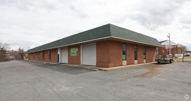
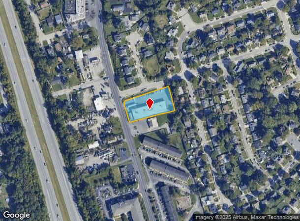
7445 E Furnace Branch Rd, Glen Burnie, MD 21060

NEARBY LISTINGS FOR SALE OR LEASE
Property Detail
7445 E Furnace Branch Rd
05-000-14122030
Marley Creek
Medicalbuilding
1 ACRE MARLEY CREEK
X
Anne Arundel
24003C0061F
Maryland
2024
1 AC
2025
Route 2 Corridor North
751103
Baltimore
12,600 SF
Baltimore-Columbia-Towson, MD
DEMOGRAPHICS near 7445 E Furnace Branch Rd
1 Mile
3 Mile
5 Mile
2024 Total Population
13,186
96,051
199,739
2029 Population
13,438
98,184
203,810
Pop Growth 2024-2029
+ 1.91%
+ 2.22%
+ 2.04%
Average Age
41
38
39
2024 Total Households
4,911
36,879
74,438
HH Growth 2024-2029
+ 1.95%
+ 2.27%
+ 2.10%
Median Household Inc
$85,560
$83,880
$91,464
Avg Household Size
2.50
2.50
2.60
2024 Avg HH Vehicles
2.00
2.00
2.00
Median Home Value
$286,016
$317,338
$336,171
Median Year Built
1958
1976
1976
Nearby Places
Map Layers
Map Styles
 Street
 Aerial
- Restaurants
- Banks
- Shops
- Fitness
- Groceries
PUBLIC TRANSPORTATION
COMMUTER RAIL
Bwi Airport (Penn Line - Maryland Area Regional Commuter Trains (The MARC))
DRIVE
WALK
Distance
Bwi Airport (Penn Line - Maryland Area Regional Commuter Trains (The MARC))
16 min
7.1 mi
AIRPORT
Baltimore/Washington International Thurgood Marshall
DRIVE
WALK
Distance
Baltimore/Washington International Thurgood Marshall
15 min
6.7 mi
Freight Ports
Port of Baltimore
DRIVE
WALK
Distance
Port of Baltimore
19 min
8.8 mi
Nearby Properties
Address
Land Use
TOTAL SIZE
Lot Size
Zoning
Address
Land Use
TOTAL SIZE
Lot Size
Zoning
637,060 SF
22.19 AC
C2
Address
Land Use
TOTAL SIZE
Lot Size
Zoning
467.03 AC
W2
Address
Land Use
TOTAL SIZE
Lot Size
Zoning
374,664 SF
22.89 AC
R15
Address
Land Use
TOTAL SIZE
Lot Size
Zoning
32.18 AC
R15
Address
Land Use
TOTAL SIZE
Lot Size
Zoning
176,405 SF
41.81 AC
C3
Address
Land Use
TOTAL SIZE
Lot Size
Zoning
383,697 SF
68.35 AC
R5
Address
Land Use
TOTAL SIZE
Lot Size
Zoning
289,829 SF
24.56 AC
C3
Address
Land Use
TOTAL SIZE
Lot Size
Zoning
285,360 SF
14.96 AC
Address
Land Use
TOTAL SIZE
Lot Size
Zoning
512,900 SF
51.15 AC
W1
Address
Land Use
TOTAL SIZE
Lot Size
Zoning
28.02 AC
R15
Address
Land Use
TOTAL SIZE
Lot Size
Zoning
19.20 AC
R15
Address
Land Use
TOTAL SIZE
Lot Size
Zoning
14.21 AC
R15
Address
Land Use
TOTAL SIZE
Lot Size
Zoning
252,911 SF
8.32 AC
R10
Address
Land Use
TOTAL SIZE
Lot Size
Zoning
15.33 AC
R15
Address
Land Use
TOTAL SIZE
Lot Size
Zoning
12.90 AC
R15
Address
Land Use
TOTAL SIZE
Lot Size
Zoning
233,408 SF
24.73 AC
C3
Address
Land Use
TOTAL SIZE
Lot Size
Zoning
21.45 AC
R15
Address
Land Use
TOTAL SIZE
Lot Size
Zoning
14.53 AC
R22
Address
Land Use
TOTAL SIZE
Lot Size
Zoning
14.58 AC
R22
Address
Land Use
TOTAL SIZE
Lot Size
Zoning
16.72 AC
R15
Address
Land Use
TOTAL SIZE
Lot Size
Zoning
7.07 AC
R15
Address
Land Use
TOTAL SIZE
Lot Size
Zoning
154,044 SF
16.89 AC
C3
Address
Land Use
TOTAL SIZE
Lot Size
Zoning
5.95 AC
R22
Address
Land Use
TOTAL SIZE
Lot Size
Zoning
277,203 SF
15.88 AC
R15
Address
Land Use
TOTAL SIZE
Lot Size
Zoning
9.45 AC
R22
Address
Land Use
TOTAL SIZE
Lot Size
Zoning
16.26 AC
R15
Address
Land Use
TOTAL SIZE
Lot Size
Zoning
340,000 SF
35 AC
W1
Address
Land Use
TOTAL SIZE
Lot Size
Zoning
12 AC
C3
Address
Land Use
TOTAL SIZE
Lot Size
Zoning
166,646 SF
4.61 AC
R22
Address
Land Use
TOTAL SIZE
Lot Size
Zoning
119,220 SF
6.99 AC
W1
The World's #1 Commercial Real Estate Marketplace
Connect with us
© 2025 CoStar Group
The information above has been obtained from sources believed reliable. While we do not doubt its accuracy we have not verified it and make no guarantee, warranty or representation about it. It is your responsibility to independently confirm its accuracy and completeness. Any projections, opinions, assumptions, or estimates used are for example only and do not represent the current or future performance of the property. The value of this transaction to you depends on tax and other factors which should be evaluated by your tax, financial, and legal advisors. You and your advisors should conduct a careful, independent investigation of the property to determine to your satisfaction the suitability of the property for your needs.