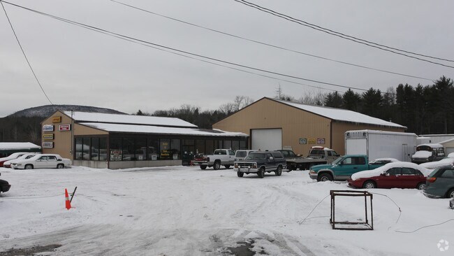
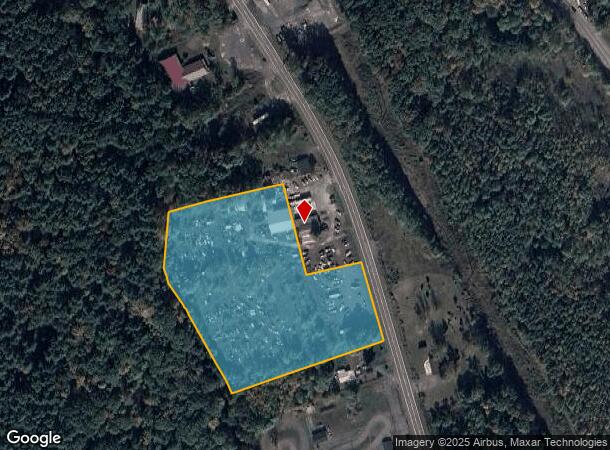
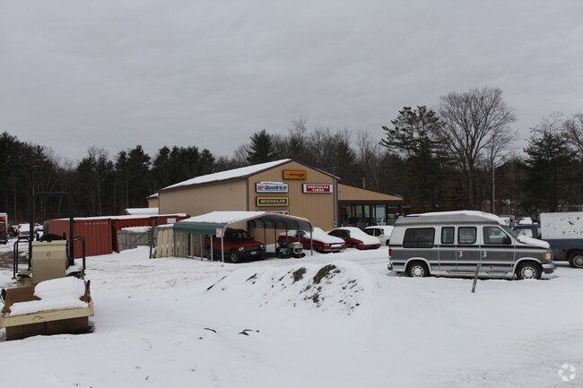
Property Record
7447 Route 32, Cairo, NY 12413
NEARBY LISTINGS FOR SALE OR LEASE
-
-
View all Cairo listings for lease on LoopNet.com
Property Detail
7447 Route 32
192400-101-000-0005-010-000-0000
Greene
Residentialacreage
New York
X
10.000
36039C0261F
5 AC
2025
Greene County
2024
Albany/Schenectady/Troy
080502
DEMOGRAPHICS near 7447 Route 32
1 Mile
3 Mile
5 Mile
2024 Total Population
619
4,608
9,029
2029 Population
608
4,625
9,129
Pop Growth 2024-2029
(1.78%)
+ 0.37%
+ 1.11%
Average Age
43
44
44
2024 Total Households
271
1,997
3,908
HH Growth 2024-2029
(2.21%)
+ 0.15%
+ 0.95%
Median Household Inc
$55,937
$64,109
$67,672
Avg Household Size
2.20
2.20
2.20
2024 Avg HH Vehicles
2.00
2.00
2.00
Median Home Value
$167,010
$193,521
$204,131
Median Year Built
1970
1977
1978
Nearby Places
Map Layers
Map Styles
 Street
 Aerial
- Restaurants
- Banks
- Shops
- Fitness
- Groceries
PUBLIC TRANSPORTATION
AIRPORT
Albany International
DRIVE
WALK
Distance
Albany International
67 min
49.6 mi
Freight Ports
Albany, NY Port
DRIVE
WALK
Distance
Albany, NY Port
48 min
36.5 mi
SALE & LEASE HISTORY
LISTING DATE
SALE/LEASE

Sep 25, 2016
For Lease
Sep 24, 2016
For Sale
Nearby Properties
Address
Land Use
TOTAL SIZE
Lot Size
Zoning
Address
Land Use
TOTAL SIZE
Lot Size
Zoning
72,654 SF
24.10 AC
01 - NOT Z
Address
Land Use
TOTAL SIZE
Lot Size
Zoning
1,800 SF
17.75 AC
01
Address
Land Use
TOTAL SIZE
Lot Size
Zoning
42,360 SF
6.73 AC
01 - NOT Z
Address
Land Use
TOTAL SIZE
Lot Size
Zoning
24,884 SF
131.20 AC
01 - NOT Z
Address
Land Use
TOTAL SIZE
Lot Size
Zoning
Address
Land Use
TOTAL SIZE
Lot Size
Zoning
2.50 AC
01 - NOT Z
Address
Land Use
TOTAL SIZE
Lot Size
Zoning
7,299 SF
1.82 AC
01 - NOT Z
Address
Land Use
TOTAL SIZE
Lot Size
Zoning
770 SF
99.10 AC
08 - GOVER
Address
Land Use
TOTAL SIZE
Lot Size
Zoning
3,666 SF
7 AC
01 - NOT Z
Address
Land Use
TOTAL SIZE
Lot Size
Zoning
4,163 SF
14.10 AC
01 - NOT Z
Address
Land Use
TOTAL SIZE
Lot Size
Zoning
21,921 SF
95.10 AC
08 - GOVER
Address
Land Use
TOTAL SIZE
Lot Size
Zoning
27,074 SF
15.84 AC
01 - NOT Z
Address
Land Use
TOTAL SIZE
Lot Size
Zoning
1,652 SF
7.61 AC
01 - NOT Z
Address
Land Use
TOTAL SIZE
Lot Size
Zoning
12,592 SF
209.10 AC
01 - NOT Z
Address
Land Use
TOTAL SIZE
Lot Size
Zoning
490 SF
71.27 AC
01 - NOT Z
Address
Land Use
TOTAL SIZE
Lot Size
Zoning
15,545 SF
10 AC
01 - NOT Z
Address
Land Use
TOTAL SIZE
Lot Size
Zoning
9,848 SF
1.36 AC
01 - NOT Z
Address
Land Use
TOTAL SIZE
Lot Size
Zoning
2,978 SF
175.50 AC
RR
Address
Land Use
TOTAL SIZE
Lot Size
Zoning
3,532 SF
3.60 AC
01 - NOT Z
Address
Land Use
TOTAL SIZE
Lot Size
Zoning
3,252 SF
122.51 AC
01 - NOT Z
Address
Land Use
TOTAL SIZE
Lot Size
Zoning
7,200 SF
2.10 AC
01 - NOT Z
Address
Land Use
TOTAL SIZE
Lot Size
Zoning
3,774 SF
1.47 AC
01 - NOT Z
Address
Land Use
TOTAL SIZE
Lot Size
Zoning
3,816 SF
0.55 AC
01 - NOT Z
Address
Land Use
TOTAL SIZE
Lot Size
Zoning
3,115 SF
2.60 AC
01 - NOT Z
Address
Land Use
TOTAL SIZE
Lot Size
Zoning
16,833 SF
100.04 AC
01 - NOT Z
Address
Land Use
TOTAL SIZE
Lot Size
Zoning
18,420 SF
3.29 AC
01 - NOT Z
Address
Land Use
TOTAL SIZE
Lot Size
Zoning
7,050 SF
2.16 AC
01 - NOT Z
Address
Land Use
TOTAL SIZE
Lot Size
Zoning
3,968 SF
1.05 AC
01 - NOT Z
Address
Land Use
TOTAL SIZE
Lot Size
Zoning
7,918 SF
23 AC
01 - NOT Z
Address
Land Use
TOTAL SIZE
Lot Size
Zoning
2,954 SF
0.87 AC
01 - NOT Z
The World's #1 Commercial Real Estate Marketplace
Connect with us
© 2026 CoStar Group
The information above has been obtained from sources believed reliable. While we do not doubt its accuracy we have not verified it and make no guarantee, warranty or representation about it. It is your responsibility to independently confirm its accuracy and completeness. Any projections, opinions, assumptions, or estimates used are for example only and do not represent the current or future performance of the property. The value of this transaction to you depends on tax and other factors which should be evaluated by your tax, financial, and legal advisors. You and your advisors should conduct a careful, independent investigation of the property to determine to your satisfaction the suitability of the property for your needs.