Property Record
7447 W 78Th St, Tulsa, OK 74131
NEARBY LISTINGS FOR SALE OR LEASE
-
-
View all Tulsa listings for sale on LoopNet.com
Property Detail
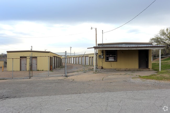
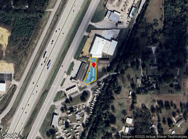
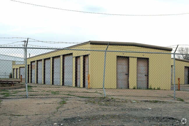
7447 W 78Th St
Tulsa, OK
Unplatted Sapulpa
1999-07-018-012-0-020-01
7-18-12 A TR IN SE SW BEG AT 3/8 IN ROD FOUND FOR NE/C OF SAID KIM TRACT 1165.23'N & 409.3' W OF SE/C OF SE SW TH S226.28' TH
Publicstorage
Creek
X
Oklahoma
40037C0190D
12
2024
0.48 AC
2025
Creek County
020101
Tulsa
4,200 SF
DEMOGRAPHICS near 7447 W 78Th St
1 Mile
3 Mile
5 Mile
2024 Total Population
1,447
13,470
61,061
2029 Population
1,466
14,052
63,467
Pop Growth 2024-2029
+ 1.31%
+ 4.32%
+ 3.94%
Average Age
40
42
40
2024 Total Households
547
5,164
23,751
HH Growth 2024-2029
+ 1.28%
+ 4.30%
+ 3.91%
Median Household Inc
$59,014
$65,746
$60,740
Avg Household Size
2.50
2.50
2.50
2024 Avg HH Vehicles
2.00
2.00
2.00
Median Home Value
$160,544
$199,060
$177,188
Median Year Built
1985
1986
1981
Nearby Places
Map Layers
Map Styles
 Street
 Aerial
- Restaurants
- Banks
- Shops
- Fitness
- Groceries
PUBLIC TRANSPORTATION
AIRPORT
Tulsa International
DRIVE
WALK
Distance
Tulsa International
26 min
18.4 mi
Freight Ports
Tulsa Port Of Catoosa
DRIVE
WALK
Distance
Tulsa Port Of Catoosa
36 min
27.7 mi
Nearby Properties
Address
Land Use
TOTAL SIZE
Lot Size
Zoning
Address
Land Use
TOTAL SIZE
Lot Size
Zoning
1,134,776 SF
35.85 AC
CN
Address
Land Use
TOTAL SIZE
Lot Size
Zoning
47,670 SF
10.05 AC
RS
Address
Land Use
TOTAL SIZE
Lot Size
Zoning
117,372 SF
11.87 AC
CN
Address
Land Use
TOTAL SIZE
Lot Size
Zoning
370,891 SF
26.43 AC
IM
Address
Land Use
TOTAL SIZE
Lot Size
Zoning
38,940 SF
16.24 AC
Address
Land Use
TOTAL SIZE
Lot Size
Zoning
2,152 SF
8.88 AC
Address
Land Use
TOTAL SIZE
Lot Size
Zoning
31,600 SF
13.46 AC
Address
Land Use
TOTAL SIZE
Lot Size
Zoning
41,444 SF
4.71 AC
CG
Address
Land Use
TOTAL SIZE
Lot Size
Zoning
4,785 SF
7.34 AC
Address
Land Use
TOTAL SIZE
Lot Size
Zoning
23,100 SF
30 AC
IM
Address
Land Use
TOTAL SIZE
Lot Size
Zoning
9,282 SF
4.83 AC
Address
Land Use
TOTAL SIZE
Lot Size
Zoning
52,050 SF
16.29 AC
Address
Land Use
TOTAL SIZE
Lot Size
Zoning
15,230 SF
8.65 AC
Address
Land Use
TOTAL SIZE
Lot Size
Zoning
86,700 SF
22.68 AC
Address
Land Use
TOTAL SIZE
Lot Size
Zoning
66,975 SF
7.80 AC
Address
Land Use
TOTAL SIZE
Lot Size
Zoning
172,256 SF
10.76 AC
Address
Land Use
TOTAL SIZE
Lot Size
Zoning
20,625 SF
13.39 AC
TM
Address
Land Use
TOTAL SIZE
Lot Size
Zoning
22,721 SF
13.12 AC
Address
Land Use
TOTAL SIZE
Lot Size
Zoning
59,780 SF
10.01 AC
IM
Address
Land Use
TOTAL SIZE
Lot Size
Zoning
8,250 SF
Address
Land Use
TOTAL SIZE
Lot Size
Zoning
8,240 SF
8.45 AC
Address
Land Use
TOTAL SIZE
Lot Size
Zoning
9,600 SF
3.02 AC
Address
Land Use
TOTAL SIZE
Lot Size
Zoning
9,360 SF
3.85 AC
C2
Address
Land Use
TOTAL SIZE
Lot Size
Zoning
1,360 SF
11.70 AC
Address
Land Use
TOTAL SIZE
Lot Size
Zoning
80,800 SF
11.94 AC
Address
Land Use
TOTAL SIZE
Lot Size
Zoning
10,822 SF
10.32 AC
Address
Land Use
TOTAL SIZE
Lot Size
Zoning
158,735 SF
12.99 AC
CH
Address
Land Use
TOTAL SIZE
Lot Size
Zoning
23,377 SF
2.68 AC
CG
Address
Land Use
TOTAL SIZE
Lot Size
Zoning
36,168 SF
1.23 AC
IL
The World's #1 Commercial Real Estate Marketplace
Connect with us
© 2025 CoStar Group
The information above has been obtained from sources believed reliable. While we do not doubt its accuracy we have not verified it and make no guarantee, warranty or representation about it. It is your responsibility to independently confirm its accuracy and completeness. Any projections, opinions, assumptions, or estimates used are for example only and do not represent the current or future performance of the property. The value of this transaction to you depends on tax and other factors which should be evaluated by your tax, financial, and legal advisors. You and your advisors should conduct a careful, independent investigation of the property to determine to your satisfaction the suitability of the property for your needs.