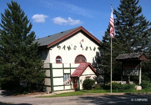
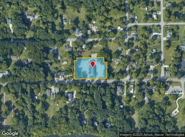
Property Record
7449 68Th St Se, Caledonia, MI 49316
NEARBY LISTINGS FOR SALE OR LEASE
Property Detail
7449 68Th St Se
West Michigan
N Brownville
Grand Rapids-Wyoming, MI
412310126024 E 17 FT OF S 173.0 FT OF LOT 4 BLK 5 ALSO PART OF LOT 3 BLK 5 COM AT SW COR OF SD LOT TH N 198 FT TH E 264 FT TH
41-23-10-126-024
Kent
Restaurantbuilding
Michigan
2024
3-4
2025
1.35 AC
014806
SE Kent County/Caledonia
6,365 SF
DEMOGRAPHICS near 7449 68Th St Se
1 Mile
3 Mile
5 Mile
2024 Total Population
1,318
13,419
31,679
2029 Population
1,334
13,704
32,126
Pop Growth 2024-2029
+ 1.21%
+ 2.12%
+ 1.41%
Average Age
42
39
39
2024 Total Households
471
4,449
11,082
HH Growth 2024-2029
+ 1.06%
+ 2.23%
+ 1.43%
Median Household Inc
$108,269
$99,748
$102,950
Avg Household Size
2.80
2.80
2.80
2024 Avg HH Vehicles
2.00
2.00
2.00
Median Home Value
$342,198
$335,279
$325,637
Median Year Built
1990
1997
1993
Nearby Places
Map Layers
Map Styles
 Street
 Aerial
- Restaurants
- Banks
- Shops
- Fitness
- Groceries
PUBLIC TRANSPORTATION
AIRPORT
Gerald R Ford International
DRIVE
WALK
Distance
Gerald R Ford International
11 min
4.9 mi
Freight Ports
Port Milwaukee
DRIVE
WALK
Distance
Port Milwaukee
315 min
270.0 mi
SALE & LEASE HISTORY
LISTING DATE
SALE/LEASE

Sep 23, 2016
For Sale
Nearby Properties
Address
Land Use
TOTAL SIZE
Lot Size
Zoning
Address
Land Use
TOTAL SIZE
Lot Size
Zoning
438,644 SF
117.24 AC
PUD
Address
Land Use
TOTAL SIZE
Lot Size
Zoning
210,096 SF
75.30 AC
PUD
Address
Land Use
TOTAL SIZE
Lot Size
Zoning
196,764 SF
R1
Address
Land Use
TOTAL SIZE
Lot Size
Zoning
165,589 SF
Address
Land Use
TOTAL SIZE
Lot Size
Zoning
508,580 SF
66.50 AC
ARC
Address
Land Use
TOTAL SIZE
Lot Size
Zoning
34,238 SF
6.43 AC
I1
Address
Land Use
TOTAL SIZE
Lot Size
Zoning
156,693 SF
R1
Address
Land Use
TOTAL SIZE
Lot Size
Zoning
11.14 AC
R4
Address
Land Use
TOTAL SIZE
Lot Size
Zoning
41,667 SF
7.46 AC
PUD
Address
Land Use
TOTAL SIZE
Lot Size
Zoning
Address
Land Use
TOTAL SIZE
Lot Size
Zoning
9.71 AC
R3
Address
Land Use
TOTAL SIZE
Lot Size
Zoning
131,200 SF
13.21 AC
I1
Address
Land Use
TOTAL SIZE
Lot Size
Zoning
78,260 SF
Address
Land Use
TOTAL SIZE
Lot Size
Zoning
5,744 SF
112.32 AC
MHC
Address
Land Use
TOTAL SIZE
Lot Size
Zoning
79,896 SF
7.17 AC
RR
Address
Land Use
TOTAL SIZE
Lot Size
Zoning
81,000 SF
11 AC
RR
Address
Land Use
TOTAL SIZE
Lot Size
Zoning
65,016 SF
7.08 AC
RR
Address
Land Use
TOTAL SIZE
Lot Size
Zoning
5.52 AC
Address
Land Use
TOTAL SIZE
Lot Size
Zoning
100,751 SF
8.45 AC
I1
Address
Land Use
TOTAL SIZE
Lot Size
Zoning
8,274 SF
54 AC
HC
Address
Land Use
TOTAL SIZE
Lot Size
Zoning
69,360 SF
Address
Land Use
TOTAL SIZE
Lot Size
Zoning
1,803 SF
5 AC
ARC
Address
Land Use
TOTAL SIZE
Lot Size
Zoning
108,900 SF
6.31 AC
I1
Address
Land Use
TOTAL SIZE
Lot Size
Zoning
100.10 AC
PUD
Address
Land Use
TOTAL SIZE
Lot Size
Zoning
12.05 AC
Address
Land Use
TOTAL SIZE
Lot Size
Zoning
48,845 SF
4.09 AC
I1
Address
Land Use
TOTAL SIZE
Lot Size
Zoning
29,125 SF
Address
Land Use
TOTAL SIZE
Lot Size
Zoning
40,504 SF
13.31 AC
RR
Address
Land Use
TOTAL SIZE
Lot Size
Zoning
52.58 AC
PUD
Address
Land Use
TOTAL SIZE
Lot Size
Zoning
78,260 SF
6.20 AC
I2
The World's #1 Commercial Real Estate Marketplace
Connect with us
© 2026 CoStar Group
The information above has been obtained from sources believed reliable. While we do not doubt its accuracy we have not verified it and make no guarantee, warranty or representation about it. It is your responsibility to independently confirm its accuracy and completeness. Any projections, opinions, assumptions, or estimates used are for example only and do not represent the current or future performance of the property. The value of this transaction to you depends on tax and other factors which should be evaluated by your tax, financial, and legal advisors. You and your advisors should conduct a careful, independent investigation of the property to determine to your satisfaction the suitability of the property for your needs.