Property Record
745 Us Highway 1, North Palm Beach, FL 33408
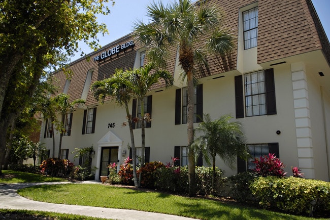
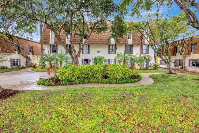

This Property Is For Sale
NEARBY LISTINGS FOR SALE OR LEASE
Property Detail
745 Us Highway 1
West Palm Beach-Boca Raton-Delray Beach, FL
Globe Condo
68-43-42-16-33-000-0020
GLOBE CONDO UNIT 1
Officecondo
Palm Beach
X
Florida
12099C0383F
2.03 AC
2024
North Palm Beach
2024
South Florida
000703
DEMOGRAPHICS near 745 Us Highway 1
1 Mile
3 Mile
5 Mile
2024 Total Population
9,486
84,086
157,110
2029 Population
9,984
88,825
165,641
Pop Growth 2024-2029
+ 5.25%
+ 5.64%
+ 5.43%
Average Age
51
46
45
2024 Total Households
4,825
36,721
65,881
HH Growth 2024-2029
+ 5.37%
+ 5.72%
+ 5.24%
Median Household Inc
$85,471
$72,886
$73,603
Avg Household Size
1.90
2.20
2.30
2024 Avg HH Vehicles
2.00
2.00
2.00
Median Home Value
$412,870
$399,865
$404,683
Median Year Built
1971
1981
1985
Nearby Places
- Restaurants
- Banks
- Shops
- Fitness
- Groceries
PUBLIC TRANSPORTATION
COMMUTER RAIL
Mangonia Park (Tri-County Commuter - South Florida Regional Transportation Authority (Tri-Rail))
DRIVE
WALK
Distance
Mangonia Park (Tri-County Commuter - South Florida Regional Transportation Authority (Tri-Rail))
13 min
5.5 mi
West Palm Beach (Tri-County Commuter - South Florida Regional Transportation Authority (Tri-Rail))
DRIVE
WALK
Distance
West Palm Beach (Tri-County Commuter - South Florida Regional Transportation Authority (Tri-Rail))
18 min
7.9 mi
AIRPORT
Palm Beach International
DRIVE
WALK
Distance
Palm Beach International
25 min
15.3 mi
Freight Ports
Port of Palm Beach
DRIVE
WALK
Distance
Port of Palm Beach
9 min
3.7 mi
Nearby Properties
Address
Land Use
TOTAL SIZE
Lot Size
Zoning
Address
Land Use
TOTAL SIZE
Lot Size
Zoning
736,483 SF
43.51 AC
CG1
Address
Land Use
TOTAL SIZE
Lot Size
Zoning
1,086,259 SF
58.36 AC
CO
Address
Land Use
TOTAL SIZE
Lot Size
Zoning
574,456 SF
43.11 AC
PCD
Address
Land Use
TOTAL SIZE
Lot Size
Zoning
351,267 SF
11.12 AC
PUD
Address
Land Use
TOTAL SIZE
Lot Size
Zoning
390,319 SF
44.34 AC
PCD
Address
Land Use
TOTAL SIZE
Lot Size
Zoning
308,087 SF
68.94 AC
P/I
Address
Land Use
TOTAL SIZE
Lot Size
Zoning
399,171 SF
6.60 AC
PCD
Address
Land Use
TOTAL SIZE
Lot Size
Zoning
195,263 SF
2.73 AC
PCD
Address
Land Use
TOTAL SIZE
Lot Size
Zoning
680,979 SF
44.87 AC
PCD
Address
Land Use
TOTAL SIZE
Lot Size
Zoning
406,434 SF
40.60 AC
P/I
Address
Land Use
TOTAL SIZE
Lot Size
Zoning
248,945 SF
10.87 AC
PO
Address
Land Use
TOTAL SIZE
Lot Size
Zoning
23.07 AC
CLIC
Address
Land Use
TOTAL SIZE
Lot Size
Zoning
270,888 SF
8.93 AC
RH
Address
Land Use
TOTAL SIZE
Lot Size
Zoning
59,520 SF
19.04 AC
C-S
Address
Land Use
TOTAL SIZE
Lot Size
Zoning
347,834 SF
8.92 AC
PCD
Address
Land Use
TOTAL SIZE
Lot Size
Zoning
433,243 SF
40.26 AC
RM-15
Address
Land Use
TOTAL SIZE
Lot Size
Zoning
150,114 SF
3.20 AC
MXD
Address
Land Use
TOTAL SIZE
Lot Size
Zoning
252,544 SF
9.95 AC
R1AA
Address
Land Use
TOTAL SIZE
Lot Size
Zoning
291,437 SF
22.02 AC
PO
Address
Land Use
TOTAL SIZE
Lot Size
Zoning
266,196 SF
17.61 AC
R-3
Address
Land Use
TOTAL SIZE
Lot Size
Zoning
109,243 SF
9.14 AC
CG1
Address
Land Use
TOTAL SIZE
Lot Size
Zoning
180,563 SF
54.46 AC
P/I
Address
Land Use
TOTAL SIZE
Lot Size
Zoning
286,353 SF
22.12 AC
RH
Address
Land Use
TOTAL SIZE
Lot Size
Zoning
381,665 SF
26.01 AC
PCD
Address
Land Use
TOTAL SIZE
Lot Size
Zoning
368,848 SF
15.86 AC
CO
Address
Land Use
TOTAL SIZE
Lot Size
Zoning
119,368 SF
5.81 AC
RH
Address
Land Use
TOTAL SIZE
Lot Size
Zoning
96,953 SF
1.61 AC
C
Address
Land Use
TOTAL SIZE
Lot Size
Zoning
204,232 SF
22.81 AC
PCD
Address
Land Use
TOTAL SIZE
Lot Size
Zoning
185,238 SF
16.63 AC
CLIC
Address
Land Use
TOTAL SIZE
Lot Size
Zoning
209,467 SF
15.20 AC
R-3
The World's #1 Commercial Real Estate Marketplace
Connect with us
© 2025 CoStar Group
The information above has been obtained from sources believed reliable. While we do not doubt its accuracy we have not verified it and make no guarantee, warranty or representation about it. It is your responsibility to independently confirm its accuracy and completeness. Any projections, opinions, assumptions, or estimates used are for example only and do not represent the current or future performance of the property. The value of this transaction to you depends on tax and other factors which should be evaluated by your tax, financial, and legal advisors. You and your advisors should conduct a careful, independent investigation of the property to determine to your satisfaction the suitability of the property for your needs.